
Following the launch of trove.scot in February 2025 we are now planning the retiral of some of our webservices. Canmore will be switched off on 24th June 2025. Information about the closure can be found on the HES website: Retiral of HES web services | Historic Environment Scotland
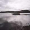
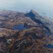
Eigg, Loch Nam Ban Mora


Dun (Prehistoric)
Site Name Eigg, Loch Nam Ban Mora
Classification Dun (Prehistoric)
Canmore ID 22148
Site Number NM48NE 15
NGR NM 45525 85229
Datum OSGB36 - NGR
Permalink http://canmore.org.uk/site/22148


- Council Highland
- Parish Small Isles
- Former Region Highland
- Former District Lochaber
- Former County Inverness-shire
Note (1928)
NOTE.
In a contribution to the Proceedings of the Society of Antiquaries on March 11, 1878 (vol. xii., 577-597), mention is made of the following additional monuments:
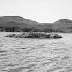
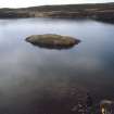
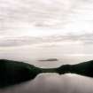
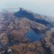
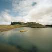
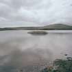
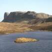
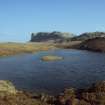
(1) "Foundations of an island dwelling" in a small loch "lying high up on the shoulder of the Scuir of Eigg, known as Lochan na Mna Moire." The island is apparently that in Lochnam Ban Mora (O.S. 6-inch), the only loch here which has an island; it is inaccessible without a boat.
(2) A cairn, "some five or six hundred yards south from Kildonnan," which provided on excavation the articles in [RCAHMS 1928] No. 2 of list on p. lvi.
(3) A cairn "a few yards further south" with articles in No 3.
(4) Cairn, "Sithean or Sguman-nan-Cailleach," containing "two cists . . . made of flat stones set on edge and laid length wise." Stones of cairn removed to fill up a drain. Sithean na Cailleich on O.S. 6-inch lxxi
The O.S. map 6-inch lxxiii. notes a stone cist just north of Kildonnan Old Church ("Ruins of Chapel," cf. Proc. Soc. Ant. Scot., as above, pp. 584-6); the site of one stone cist found in 1861, and of another in 1864, in Galmisdale; the sites of two crosses (lxxi., lxxii.) and Tobar Challuim Chille ("Columba's Well") in Cleadale (lxxi).
RCAHMS 1928
Desk Based Assessment (7 June 1966)
NM48NE 15 4554 8523
See also NM48SE 15.
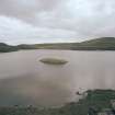
Loch na Mna Moire (= Loch nam Ban Mora) Eigg, contains a crannog, 50 yards from the shore, 35 x 15 ft.
It has the tradition of once being inhabited by abnormally big women.
Information from OS (BRS) 7 June 1966
Source: F O Blundell 1913; Donaldson 1923
Field Visit (4 May 1972)
This is not a crannog, but a small dun, typical of many of the poorly built island fortifications of the western isles. It occupies a natural rocky islet which has probably been artificially enlarged, and consists of a roughly D-shaped wall conforming to the edge of the islet, measuring overall 14.0m NNW-SSE by 8.5m transversely. The wall, best preserved on the straight landward side in the ENE where the outer face survives to a height of 1.2m, appears to have been about 1.3m thick, and is built of similar pitchstone block and in the same style as the fort wall on Sgurr of Eigg (NM48SE 6). It has mainly collapsed elsewhere and there is no trace of the entrance. The interior in uneven and heavily turfed and there is no definite sign of internal structure.
Visited by OS (ISS) 4 May 1972.
Field Visit (11 July 2001)
This dun is generally as described by OS 1972.
EIGG01 631
Visited by RCAHMS (AGCH, MTFR) 11 July 2001
See also RCAHMS 1928, 220 and Macpherson 1878, 578.

