
Following the launch of trove.scot in February 2025 we are now planning the retiral of some of our webservices. Canmore will be switched off on 24th June 2025. Information about the closure can be found on the HES website: Retiral of HES web services | Historic Environment Scotland
Iona, Iona Nunnery


Nunnery (13th Century) - (15th Century)
Site Name Iona, Iona Nunnery
Classification Nunnery (13th Century) - (15th Century)
Canmore ID 21621
Site Number NM22SE 14
NGR NM 28487 24095
Datum OSGB36 - NGR
Permalink http://canmore.org.uk/site/21621


First 100 images shown. See the Collections panel (below) for a link to all digital images.
- Council Argyll And Bute
- Parish Kilfinichen And Kilvickeon
- Former Region Strathclyde
- Former District Argyll And Bute
- Former County Argyll
NM22SE 14.00 28487 24095.
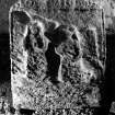
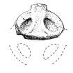
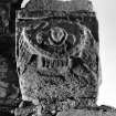
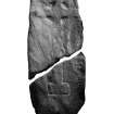
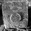
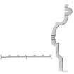
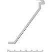
NM22SE 14.01 2843 2410 Iona Nunnery Sheela-na-gig
For (restored) Iona Abbey or St Mary's Cathedral (NM 2867 2451), see NM22SE 5.
(NM 2843 2410) Nunnery (NR) (In Ruins)
OS 6" map, Argyllshire, 2nd ed., (1900)
The remains of an Augustinian priory founded in 1207 or 1208 and dedicated to St Mary (Skene 1873) or St Oran (Pennant 1934).
In 1574 the prioress and convent disposed of the lands, which suggests that the priory was dissolved about that time.
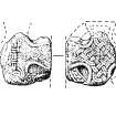
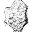
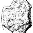
The remains, substantial and, at least in part, original were repaired in 1923 and the cloister garth planted as a memorial garden. Many early sculptured stones are preserved in the convent.
In the NMAS are four silver spoons and a broken gold fillet found during preservation work in December 1922 at the base of the south respond of the chancel arch. There were indications that they had been deposited, wrapped in linen, in the 13th century.
The priory is sometimes attributed to the Benedictines, but Vatican records describe it as Augustinian.
D E Easson 1957; D MacGibbon and T Ross 1896-7; A O Curle 1924; W F Skene 1875; T Pennant 1774; A Ritchie and E Ritchie 1934.
The remains of the priory are as described and planned.
Visited by OS (JP) 8 June 1972.
NM22SE 5 (Abbey); NM 284 240 (Nunnery) Resistivity and geophysical surveys were undertaken at Iona Abbey (see NM22SE 5) and Nunnery by Geophysical Surveys of Bradford for AOC(Scotland)Ltd.
At the Nunnery, a broad, curvilinear magnetic anomaly appears to respect the NE corner of the convent buildings. While this may simply represent an igneous geological feature, it may, alternatively, represent buried road metalling in igneous materials. In the same part of the site, a rectilinear group of features offering high resistance may represent buried wall-butts.
Sponsor: Iona Cathedral Trust Ltd.
J O'Sullivan 1995.
Iona, Iona Nunnery.
IG Lindsay Coll, W/114.
Iona, Iona Nunnery.
Ross sketch books MS 28/463/13/7 - unable to locate at time of upgrade 12.4.2000.
Iona, Iona Nunnery.
MISCELLANEOUS:
National Library - Scottish Notes and Queries, Feb 1931 - drawing by Thos. Ross.
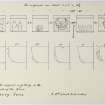
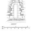
Measured Survey (November 1917)
External Reference (February 1931)
National Library - Scottish Notes and Queries, Feb 1931 - drawing by Thos. Ross.
Field Visit (10 March 1939)
Reference (1957)
The remains of an Augustinian priory founded in 1207 or 1208 and dedicated to St Mary (Skene 1873) or St Oran (Pennant 1934).
In 1574 the prioress and convent disposed of the lands, which suggests that the priory was dissolved about that time.
The remains, substantial and, at least in part, original were repaired in 1923 and the cloister garth planted as a memorial garden. Many early sculptured stones are preserved in the convent.
In the NMAS are four silver spoons and a broken gold fillet found during preservation work in December 1922 at the base of the south respond of the chancel arch. There were indications that they had been deposited, wrapped in linen, in the 13th century.
The priory is sometimes attributed to the Benedictines, but Vatican records describe it as Augustinian.
D E Easson 1957; D MacGibbon and T Ross 1896-7; A O Curle 1924; W F Skene 1875; T Pennant 1774; A Ritchie and E Ritchie 1934.
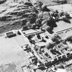
Aerial Photography (April 1969)
Oblique aerial photographs of sites and monuments on Iona, Argyll, photographed by John Dewar in 1969.
Measured Survey (1970 - 1971)
Field Visit (8 June 1972)
The remains of the priory are as described and planned.
Visited by OS (JP) 8 June 1972.
Photographic Survey (1973)
Field Visit (June 1980)
Iona Nunnery
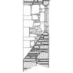
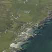
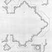
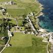
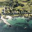
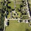
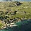
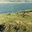
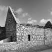
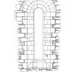
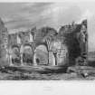
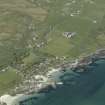
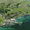
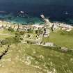
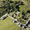
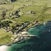
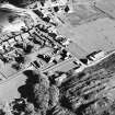
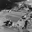
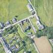
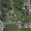
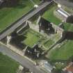
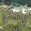
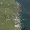
The remains of this Augustinian nunnery stand on the raised beach about 400 m sw of the Abbey, and close to the landing-place at St Ronan's Bay. To the w, the rocky eminence of Cnoc Mór (66m OD) gives the site a certain amount of shelter from the prevailing winds. The remains comprise the nunnery church, together with portions of associated conventual buildings lying on the s side. The original early-13th-century layout is to a large extent preserved, and most of the existing buildings can be ascribed to this period, apart from the S and W claustral ranges, which were enlarged and rebuilt around a more spacious c1oister-garth towards the end of the 15th century. Certain alterations were also made to the church at this time in order to increase the amount of accommodation and to provide an additional altar-chapel. Following the cessation of religious life in the 16th century the buildings gradually become ruinous, and remained derelict until about 1874, when the surviving portions of the fabric were repaired and consolidated; the church was partially restored in 1923.
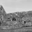
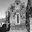
The church itself is fairly well preserved, much of the W and N walls, together with the restored N chapel, standing almost to their original heights . The chancel-arch and the vault and most of the E wall of the chancel, however, collapsed about 1832, while the s wall of the nave and the walls of the N aisle are also reduced to their lower courses, as are those of the E range of conventual buildings. Much of the s range of the cloister stands to its full height, together with part of the inner wall of the w range, but the outer wall of the w range and much of its internal area lie beneath the roadway that skirts the wand s sides of the site.
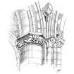
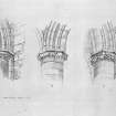
The buildings are constructed partly of red granite boulders and partly of dark-grey rubble comprising mainly basalt and Torridonian flagstones . The latter are readily available on the island, as for example in the outcrops on the adjacent foreshore , while the granite was probably obtained from local glacial boulders and erratic blocks. The dressings are of yellowish-green Carsaig sandstone, whose poor weathering-qualities have led to considerable deterioration in the condition of nearly all early carvings and mouldings. Some of the nunnery buildings appear to have been roofed with micaceous flags, a number of which can be seen built into the sides of the beam-sockets associated with the w nave-gallery of c. 1500; these were probably quarried in the Ross of Mull.
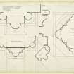
Although the drawings prepared for inclusion in this Inventory are based on recent in situ measurements, reference has also been made to detailed survey-drawings made by Sir Henry Dryden and John Watson in 1874-5,when some of the mouldings were in a better state of preservation. A number of 18th- and 19th-century drawings are also available which, although not accurate in detail, preserve a valuable record of parts of the building which have since collapsed.
See RCAHMS 1982 pp. 152-79 for a full account of the building.
RCAHSM 1982, visited June 1980
Field Visit (1980)
8m W of the midden B (NL58SE 6) are 2 small cairns, the larger c. 3.5m across and 'horse-shoe' shaped in plan, and 0.6m high. The other lies 4m to the SW and is c. 2.5m across. Both cairns appear to be stratigraphically earlier than the midden. In the E edge of the larger cairn a rim of Iron Age type pottery was found in 1971.
C B Buxton 1981.
Earth Resistance Survey (1995)
NM22SE 5 (Abbey); NM 284 240 (Nunnery) Resistivity and geophysical surveys were undertaken at Iona Abbey (see NM22SE 5) and Nunnery by Geophysical Surveys of Bradford for AOC(Scotland)Ltd.
At the Nunnery, a broad, curvilinear magnetic anomaly appears to respect the NE corner of the convent buildings. While this may simply represent an igneous geological feature, it may, alternatively, represent buried road metalling in igneous materials. In the same part of the site, a rectilinear group of features offering high resistance may represent buried wall-butts.
Sponsor: Iona Cathedral Trust Ltd.
J O'Sullivan 1995.
Field Visit (April 1996 - May 1996)
The remains of an Augustinian priory founded in 1207 or 1208 and dedicated to St Mary (Skene 1873) or St Oran (Pennant 1774).
In 1574 the prioress and convent disposed of the lands, which suggests that the priory was dissolved about this time.
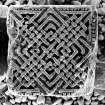
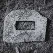
A variety of early and later medieval sculptured stones are now stored in St Ronan's Church - part of the Nunnery.
Excavation within the church in advance of restoration revealed potentially early Christian inhumations cut into the raised beach.
Monitoring the laying of a new BT cable in 1996 around the Nunnery revealed structural evidence as well as midden material.
(ION96 086)
Information from NTS (SCS) January 2016

