
Following the launch of trove.scot in February 2025 we are now planning the retiral of some of our webservices. Canmore will be switched off on 24th June 2025. Information about the closure can be found on the HES website: Retiral of HES web services | Historic Environment Scotland
Berneray, Dun Briste


Fort (Prehistoric)
Site Name Berneray, Dun Briste
Classification Fort (Prehistoric)
Canmore ID 21378
Site Number NL58SW 3
NGR NL 5485 8057
Datum OSGB36 - NGR
Permalink http://canmore.org.uk/site/21378


- Council Western Isles
- Parish Barra
- Former Region Western Isles Islands Area
- Former District Western Isles
- Former County Inverness-shire
NL58SW 3 5485 8057.
(NL 54858057) Dun Briste (NR).
OS 6"map, Inverness-shire, 1st ed., (1880)
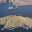
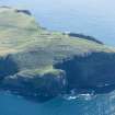
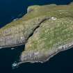
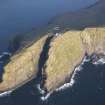
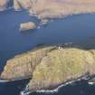
Promontory Fort, Dun Briste: A small promontory running westward into the Atlantic, with precipitous flanks, is defended by a stone wall, built across the landward end, which "measures about 75 feet in length, and varies from 5 to 10 feet in width. The remains consist of two rows of stone slabs set on edge on the outer and inner faces, the interior apparently having been filled in with stone and earth. The entrance is not distinguishable. Abutting on the inside of the wall are several hut circles of stone, of which the best preserved lies behind the southern end of the wall and measures about 12 feet in diameter internally" RCAHMS 1928, visited 10 June 1915
Dun Briste is as described by the RCAHMS. The 4 small sub circular structures, composed of grass-covered stones, 0.5m max. height, apparently associated with the fort, against the inner wall face, are almost certainly not hut circles.
Surveyed at 1:10, 560.
Visited by OS (N K B) 21 May 1965.
BY16: The wall, an impressive monument, is badly damaged and eroding, mostly as a result of sheep/rabbit action and weathering. There are no visible traces of structures on the headland itself.
P Foster 1992a; NMRS MS/595/7.
Field Visit (10 June 1915)
Promontory Fort, Dun Briste, Berneray.
On the north-west of the island of Berneray is a small promontory running westward into the Atlantic, with precipitous flanks rising about 300 feet above the sea. This promontory, known as Dun Briste, is defended by a stone wall built across the landward end. The wall is much dilapidated and measures about 75 feet in length, and varies from 5 to 10 feet in width. The remains consist of two rows of stone slabs set on edge on the outer and inner faces, the interior apparently having been filled in with stone and earth. The entrance is not distinguishable. Abutting on the inside of the wall are several hut circles of stone, of which the best preserved lies behind the southern end of the wall and measures about 12 feet in diameter internally.
RCAHMS 1928, visited 10 June 1915.
OS map: Barra lxx.
Desk Based Assessment (7 December 1964)
NL 54858057) Dun Briste (NR).
OS 6"map, Inverness-shire, 1st ed., (1880)
Promontory Fort, Dun Briste: A small promontory running westward into the Atlantic, with precipitous flanks, is defended by a stone wall, built across the landward end, which "measures about 75 feet in length, and varies from 5 to 10 feet in width. The remains consist of two rows of stone slabs set on edge on the outer and inner faces, the interior apparently having been filled in with stone and earth. The entrance is not distinguishable. Abutting on the inside of the wall are several hut circles of stone, of which the best preserved lies behind the southern end of the wall and measures about 12 feet in diameter internally"
Information from OS (MSG) 7 December 1964
Source: RCAHMS 1928, visited 10 June 1915
Field Visit (21 May 1965)
Dun Briste is as described by the RCAHMS. The 4 small sub circular structures, composed of grass-covered stones, 0.5m max. height, apparently associated with the fort, against the inner wall face, are almost certainly not hut circles.
Surveyed at 1:10, 560.
Sketch plan at 1/1250 on record card
Visited by OS (N K B) 21 May 1965.
Field Visit (1992)
BY16: The wall, an impressive monument, is badly damaged and eroding, mostly as a result of sheep/rabbit action and weathering. There are no visible traces of structures on the headland itself.
P Foster 1992a; NMRS MS/595/7.
Field Visit (5 May 2010)
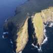
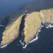
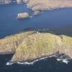
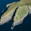
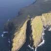
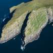
This fort is spectacularly sited on a promontory forming a spur of the western cliffs edging the northern flank of Berneray, about 80m above the sea and almost 100m below the Barra Head Lighthouse. From a terrace forming a shallow saddle, the ground rises into the promontory, which is rocky and uneven, and the interior of the fort measures no more than 50m in length by 25m in breadth behind a thick wall drawn obliquely across its landward side. On the S, where the wall picks up the line of the precipitous outcrops of the cliffs, it is about 3m thick, thinning northwards to only 2.2m before petering out as the slope plunges away on the N.
The character of the wall is unusual: its faces combine laid stones and upright slabs, most of the latter standing in the southern sector where it is thickest. Of the inner face, the tallest of these stones stands about 1.1m high, while those of the outer face measure up to 0.9m in breadth by 1.2m in height. Some 3.5m outside the wall, an intermittent line of boulders may represent the remains of the face of an outer wall, though there is no trace of any wall-core behind them. The position of the entrance is uncertain, though possibly marked by two of the upright slabs in the outer face and blocked by the construction of two small buildings against the inner face. The southern of these buildings measures 3.8m from ENE to WSW by 2.8m internally and its wall comprises a stone inner face to a bank about 1.3m in thickness by 0.3m in height. The northern is of similar construction and on the same axis, measuring about 4.4m in length by 2.5m in breadth internally, but a slab set transversely within the interior is possibly the remains of a partition dividing it into two compartments.
Visited by RCAHMS SH and JH 5 May 2010
Note (4 November 2014 - 23 May 2016)
This fort is situated on a promontory projecting from the western cliffs on the sloping N flank of the island of Berneray. The main defence comprises a single thick wall, which faces onto the shallow saddle on the E, cutting obliquely NE across the neck from the outcrops forming the cliffs along the S margin and petering out on the slope that plunges away on the N. The wall displays an unusual style of construction and its faces combine both laid and upright slabs, the latter up to 1.2m in height and mainly occurring where the wall is thickest on the SW; it thins to 2.2m towards the NE. The position of the entrance is uncertain, though possibly marked by two of the upright slabs visible in the outer face and blocked by two small building set against the inner face. These buildings measure 3.8m by 2.8m and 4.4m by 2.5m respectively within wall copsed of a bank with an internal slab face; a transverse slab within the interior of the longer is possibly a partition. These are the only structures visible within the rocky and uneven interior, which measures about 50m from E to W by a maximum of 25m transversely (0.12ha). The only other feature visible is an intermittent line of boulders some 3.5m outside the line of the wall, possibly indicating the line of a robbed out outer defence.
Information from An Atlas of Hillforts of Great Britain and Ireland – 23 May 2016. Atlas of Hillforts SC2481

