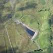
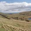
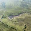
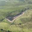
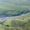
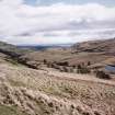
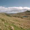
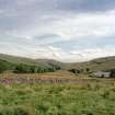
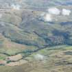
Accessibility

Font Size

100% 150% 200%

Background Colour

Default Contrast
Close Reset

Lossburn Reservoir

Reservoir (Period Unassigned)

Site Name Lossburn Reservoir

Classification Reservoir (Period Unassigned)

Canmore ID 188028

Site Number NS89NW 94

NGR NS 83218 98994

NGR Description From NS 8234 9889 to NS 8332 9895

Datum OSGB36 - NGR

Permalink http://canmore.org.uk/site/188028

Ordnance Survey licence number AC0000807262. All rights reserved.
Canmore Disclaimer. © Bluesky International Limited 2025. Public Sector Viewing Terms

Toggle Aerial | View on large map

Digital Images

Oblique aerial view.
Oblique aerial view.General view of Menstrie Glen from Ashentrool (NS89NW 56.00) looking south-east.Oblique aerial view of Lossburn Reservoir at low water level, looking S.Oblique aerial view of Lossburn Reservoir at low water level, looking SSW.Oblique aerial view of Lossburn Reservoir at low water level, looking SSE.General view of Menstrie Glen from Ashentrool (NS89NW 56.00) looking south-east.General view to south-east of Menstrie Glen from Ashentrool towards Loss.
Scan of D/59286/CN, ground view of Menstrie Glen. Scanned for Menstrie Glen publication.General view of Menstrie Glen from Ashentrool towards Loss.  The stone dyke in the foreground is one of the new land divisions laid out in the 1760's. It marks the march between Ashentrool and Loss and the line of trees leading away on the left of the picture follows the boundary of the emparkemnt established between Loss and Townhead.General oblique aerial view of Menstrie Glen centred on Backside of Lipney showing the recent afforestation, looking NE.

Administrative Areas

  • Council Stirling
  • Parish Logie (Stirling)
  • Former Region Central
  • Former District Stirling
  • Former County Stirlingshire

Activities

Aerial Photography (10 September 2014)

Out of Fife, photographing golf courses and castles in the Alexandria, Greenock, Paisley, Barrhead and Newton Mearns areas. Weather was fine in the main however varying degrees of haze meant that photographing to the south and south west proved to be difficult to get a good enough image.

Aerial Photography (4 September 2018)

Out of Fife to undertake recording of SNH/HLA sites in the Fife, Perthshire and Loch Venacher areas. This is another comparative test flight for the above project. Weather was fine.

References

MyCanmore Image Contributions


Contribute an Image

MyCanmore Text Contributions