
Harris, Leverburgh


Village (Period Unassigned)
Site Name Harris, Leverburgh
Classification Village (Period Unassigned)
Alternative Name(s) An T-ob; Obbe
Canmore ID 171112
Site Number NG08NW 14
NGR NG 0193 8670
NGR Description Centred NG 0193 8670
Datum OSGB36 - NGR
Permalink http://canmore.org.uk/site/171112


- Council Western Isles
- Parish Harris
- Former Region Western Isles Islands Area
- Former District Western Isles
- Former County Inverness-shire
Leverburgh (Obbe - An t-Òb, before 1920)
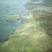
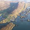
Watery settlement on the reef-ridden Sound of Harris, its abandoned, half-complete air far from picturesque, but significant as the legacy of the most ambitious industrial enterprise ever initiated by a Hebridean laird. Lord Leverhulme's principal motivation was an attempt to bring employment and a measure of prosperity to a community struggling to maintain a livelihood in the aftermath of the Clearances. His £250,000 scheme was to have transformed the straggling township into a significant herring port, and for a brief period 70 steam trawlers supplied fish-processing factories here, employing hundreds. But today, all that survives of Leverhulme's dream are a ferro-concrete water tower, circular battered water reservoir, and some foundations of the power house, coopering sheds, fisher girls' quarters and quayside buildings. All this, plus road layout, by D. Cattanach and B. P. Wall (Lever Bros engineer), c.1920. Also part of Leverhulme's legacy, c.1924 , is the school, built as a recreation hall (Hulme Hall), and some houses for managers and foremen built " of stone or concrete blocks with asbestos composition and slated roofs", as at Ferry Road. Families were offered a quarter acre plot and £250-worth of building materials to erect one of several approved designs. But plans to cut a canal through from the sea to the large sheltered "millpond" to create an inner harbour capable of accommodating a fleet of 200 boats remained unfulfilled, and Leverhulme's death in 1925 spelt the end of this extravagant but shortlived attempt to transform Harris's economy. Little today in gritty, scruffy Leverburgh pre-dates the 20th century. "Its architectural medley is now being completed by the erection of Swedish houses" wrote George Scott- Moncrieff in 1961 of the timber clad prefabs in Dunmore Crescent (a house type favoured by the Forestry Commission and seen throughout the Highlands). These had a precedent, since Leverhulme had imported some pre-fab wooden houses from Norway after discarding his first idea of building workers' houses of reinforced peat.
The houses of modern Leverburgh contrast starkly with the lost vernacular, described by Osgood Mackenzie, in 1853: @ike most of the native houses, [the house is] very long, considering its height and its width inside, because these Hebridean houses have to contain not only the family, but also the whole stock of cattle, not to mention sundry pet sheep and innumerable hens, with no division of any kind between the animals and the human beings. I should say the house was a good forty-five feet long, with the usual low, broad walls, six feet thick, built partly of stones, but mostly of turf, and only some five feet in height, on which grass grows and sheep and sometimes even a calf may be seen grazing happily. What surprises a stranger at first sight is that instead of the thatched roof extending, as in all other parts of the world, a little beyond the outside of the walls, so that the drip from the roof may fall clear of the dwelling, the couples which sustain the roof invariably rest on the inside edge of these wide walls. This arises chiefly from the fact that there is no wood on the Long Island, with the exception of the few comparatively young trees in the plantations round the policies of Stornoway Castle and Rodal ...". They entered the house, " very narrow (only about twelve feet wide inside), by a door near one end, and had to make our way along through manure and litter, there being only just room between the tails of the eight or ten cattle beasts and the wall for us to squeeze up to the end where the fire was burning against the gable and where was also the bed."
Taken from "Western Seaboard: An Illustrated Architectural Guide", by Mary Miers, 2008. Published by the Rutland Press http://www.rias.org.uk

NG08NW 14 centred 0193 8670
Photographic Record (1906)
Photographs taken during a visit by the Churches Commission in July 1906.
The photographs are available in PA 71.

