
Scheduled Maintenance
Please be advised that this website will undergo scheduled maintenance on the following dates: •
Tuesday 3rd December 11:00-15:00
During these times, some services may be temporarily unavailable. We apologise for any inconvenience this may cause.
North Sutor, Coast Battery, Reservoir


Drain(S) (First World War) (1913), Reservoir (First World War) (1913), Settling Tank (First World War) (1913), Sheepfold (20th Century)
Site Name North Sutor, Coast Battery, Reservoir
Classification Drain(S) (First World War) (1913), Reservoir (First World War) (1913), Settling Tank (First World War) (1913), Sheepfold (20th Century)
Alternative Name(s) Cromarty Defences; Castlecraig; Fort North Sutor; Site No. 1
Canmore ID 170755
Site Number NH86NW 9.09
NGR NH 81844 69195
NGR Description Centred NH 81844 69195
Datum OSGB36 - NGR
Permalink http://canmore.org.uk/site/170755


- Council Highland
- Parish Nigg (Ross And Cromarty)
- Former Region Highland
- Former District Ross And Cromarty
- Former County Ross And Cromarty
NH86NW 9.09 centred 81844 69195
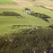
Hut bases and water supply tank.
Note (29 July 2013)
Large water tank sites some 225m N of the camp site for the North Sutor battery. It is shown on a plan of the completed site (The National Archives WO 78/5192).
Information from RCAHMS (AKK) 29 July 2013.
Project (March 2013 - September 2013)
A project to characterise the quantity and quality of the Scottish resource of known surviving remains of the First World War. Carried out in partnership between Historic Scotland and RCAHMS.
Field Visit (28 March 2019)
The water supply for the battery formed part of the infrastructure introduced by the Admiralty in World War 1. There are few surface remains: a large reservoir (NH 81838 69188) was originally situated 225m NNW of the N gate (NH86NW 77), immediately behind the most southerly of the Castle Craig farm cottages, but this has been demolished and replaced with a tennis court. Inspection covers associated with the drainage system are relatively common (NH 81794 68958; NH 81862 68991; NH 81895 69007; NH 81946 69032; NH 81952 69034; NH 82007 69042; NH 82061 69047; NH 82115 69053). There is also a settling tank (NH 82124 69053), situated 16.5 N of the World War 2 security fence (NH86NW 9.51) at the head of a deep gully, which still conveys waste water into the burn below. It is rectangular on plan and measures 4.1m from WNW to ESE by 2m transversely and up to 1.5m in height.
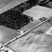
The reservoir is shown on a plan held at the National Archives at Kew (WO78/5192) and on a sketch map entitled ‘Telephone Circuits’, dated 7 May 1919, which is also held in the National Archives at Kew (ADM 7/942). It is also shown on an aerial photograph (106G/RAF/0751, 6040) flown on 31 August 1945.
The 'Hut Bases and Water Supply Tank' described by an earlier authority appear to be a hard standing for sheep pens, which are also shown on the aerial photograph (106G/RAF/0751, 6040) flown on 31 August 1945.
Visited by HES, Survey and Recording (ATW, AKK), 28 March 2019.

