
Following the launch of trove.scot in February 2025 we are now planning the retiral of some of our webservices. Canmore will be switched off on 24th June 2025. Information about the closure can be found on the HES website: Retiral of HES web services | Historic Environment Scotland
Glasgow, Dalmarnock, Eastern Railway Bridge


Railway Bridge (19th Century)
Site Name Glasgow, Dalmarnock, Eastern Railway Bridge
Classification Railway Bridge (19th Century)
Alternative Name(s) Dalmarnock, Second Railway Bridge; River Clyde
Canmore ID 165928
Site Number NS66SW 364
NGR NS 61362 62513
Datum OSGB36 - NGR
Permalink http://canmore.org.uk/site/165928


- Council Glasgow, City Of
- Parish Glasgow (City Of Glasgow)
- Former Region Strathclyde
- Former District City Of Glasgow
- Former County Lanarkshire
NS66SW 364 61362 62512
Location formerly cited as NS 6136 6251.
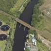
For Western (first) railway bridge at this crossing-point, see NS66SW 365.
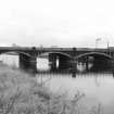
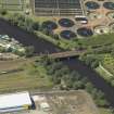
Railway bridges, Dalmarnock, built [NS66SW 365] c. 1858 by G Graham, engineer, and [NS66SW 364] 1893-7 for the Caledonian Rly. Two iron bridges, each carrying two tracks. The eastern one [NS66SW 364] consists of three wrought-iron arches on sandstone piers with rounded cutwaters, approached on both sides by brick arches with sandstone soffits and parapets.
J R Hume 1974.
(Railway Bridges, Dalmarnock). The second [Dalmarnock] bridge, also for the Caledonian Rly, and on a pronounced skew, has three steel arches over the river and three brick arches in the approaches: piers and abutments of stone. A construction joint through the middle of all the piers shows that there were two periods of building, probably 1893-7 and c. 1923. Each arch is of ten ribs, five in each construction period. The spandrel members are vertical and carry the trackbed on steel cross-beams with brick jack-arches.
E Williamson, A Riches and M Higgs 1990.
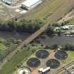
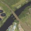
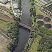
This bridge carries the now-electrified Glasgow (Central) - Bridgeton - Rutherglen suburban line of the former Caledonian Rly over the River Clyde, which here forms the boundary between the parishes of Glasgow (to the N) and Rutherglen (to the S). It is situated about 10m E of the earlier bridge (NS66SW 365), and skew to the river.
The cited location defines the centre of the span. The bridge is depicted (but not noted) on the relevant sheets of the OS 1:1250 map, both of which date from 1968. It appears to have extended from NS c. 61352 62550 to NS c. 61370 62455.
Information from RCAHMS (RJCM), 14 December 2005.
Construction (1897)
Project (2007)
This project was undertaken to input site information listed in 'Civil engineering heritage: Scotland - Lowlands and Borders' by R Paxton and J Shipway, 2007.
Publication Account (2007)
In 1897 a new twin-track bridge was completed immediately upstream with three arch main spans 60 ft 7 in. on the square, the river piers being in line with those of the existing bridge. Each span consists of six, two-pinned steel arch ribs 2 ft 8 in. deep. The longitudinal plate girders over the arched ribs are 14 in. deep. The river piers are of ashlar masonry with rubble hearting founded on two concrete-filled steel caissons 22 by 16 by 8 1/2ft deep.
The contractor was Michael Alexander. In 1923 the bridge was widened to take four tracks by P. & W. Anderson.
R Paxton and J Shipway 2007
Reproduced from 'Civil Engineering heritage: Scotland - Lowlands and Borders' with kind permission of Thomas Telford Publishers.

