
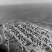
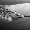
Burghead Harbour


Harbour (19th Century)
Site Name Burghead Harbour
Classification Harbour (19th Century)
Alternative Name(s) Burghead Bay; Moray Firth
Canmore ID 16199
Site Number NJ16NW 58
NGR NJ 10820 69020
NGR Description Centred NJ 10820 69020
Datum OSGB36 - NGR
Permalink http://canmore.org.uk/site/16199


- Council Moray
- Parish Duffus
- Former Region Grampian
- Former District Moray
- Former County Morayshire
NJ16NW 58.00 centred 10820 69020
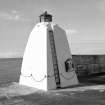
NJ16NW 58.01 NJ 10674 68965 North Pier, Pierhead light (beacon)
NJ16NW 58.02 NJ 10770 68998 South Pier, Pierhead light (beacon)
NJ16NW 58.03 NJ 10676 68937 North Pier (extension), Pierhead light (beacon)
For adjacent granaries (NJ 1082 6908 to 1099 6900), see NJ16NW 59.
For associated coastguard station (NJ 1083 6913), lookout and storm signal (NJ 1084 6917), see NJ16NW 88.00 and NJ16NW 88.01 respectively.
Architect: Thomas Telford, 1803-21.
(Undated) information in NMRS.
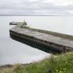
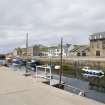
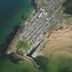
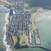
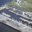
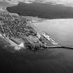
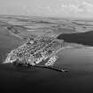
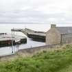
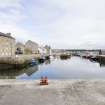
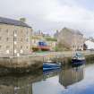
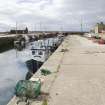
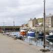
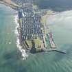
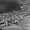
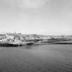
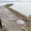
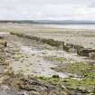
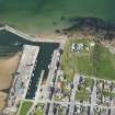
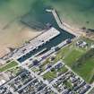
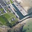
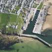
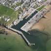
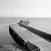
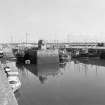
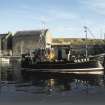
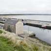
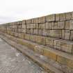
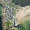
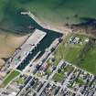
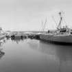
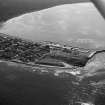
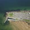
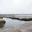
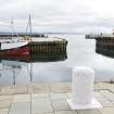
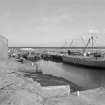
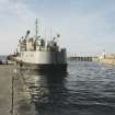
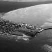
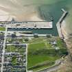
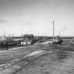
(Location cited as NJ 108 690). Burghead Harbour, built 1807-10 and improved in 1832, 1835 and 1881-7. A narrow rectangular basin, with the entrance at one end, at right-angles to the long axis, and protected by an irregular breakwater. There is a sloping beach opposite the entrance to absorb the kinetic energy of entering waves. At the seaward end of the breakwater is a pyramidal concrete light tower. The landward end of the basin is bisected by a rectangular quay, giving additional berths for fishing vessels.
J R Hume 1977
Burghead provides an interesting example of a promontory fort (NJ16NW 1) whose landward connexion gave natural shelter to shipping but the earliest substantial record is to be found in the OSA where the minister pleads (1793) for the construction of a good harbour, laying stress on the natural advantages of good shelter, fine bottom, adequate depth of water and freedom from shoals and sandbanks. The place was, at that date, a fishing village which also engaged in seaborne trade.
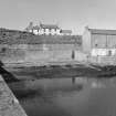
Improvement began in 1809 when a good harbour was built showing well-squared unmortared blocks with a moulded string-course some 4 ft (1.2m) below the top of the wall; at low-tide water-level the blocks were set vertically. The plan (in the Reports of the Parliamentary Harbour Commissioners, 1847) is dated 1835 and shows a basin about 650 ft (198m) long, aligned along the SW side of the promontory and with its entrance protected by a breakwater-jetty projecting SSW.
In 1834 this breakwater was extended by 40 yds (36.5m) with a further extension in 1839; the corresponding changes in the masonry can still be seen. A depth of 16 ft (4.8m) at high water springs was thus obtained. The report of 1847 likewise notes how the westerly aspect and sheltered position of the harbour made for safety.
In 1835 the harbour was used by some 400 vessels, 12 being owned in the village. Trade was carried on with Leith, London and continental ports, and steamers were making their appearance.
OSA 1791-9; NSA 1845; A Graham 1979.
Air photographs: AAS/97/12/G27/12 and AAS/97/12/CT.
NMRS, MS/712/29.
Construction (1807 - 1812)
This small rectangular harbour on the south-west side of the promontory at Burghead was built from 1807–12 by day labour supervised by Andrew Forsythe, mason of Elgin.
R Paxton and J Shipway 2007
Reproduced from 'Civil Engineering heritage: Scotland - Highlands and Islands' with kind permission from Thomas Telford Publishers.
Publication Account (2007)
Burghead Harbour
(Historic Engineering Works no. HEW 2530)
This small rectangular harbour on the south-west side of the promontory at Burghead was built from 1807–12 by day labour supervised by Andrew Forsythe, mason of Elgin. A short pier at the entrance provided shelter to
vessels entering the harbour and by 1835 this had been extended by the construction of a breakwater.
Although a short pier has been constructed within the basin and the external harbour wall has been widened externally to provide more quay space, the harbour retains much of its original character. There is a number of early-19th century warehouses on the quayside.
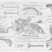
Telford had an involvement only when it became necessary for the local promoters to apply to the Highland Roads & Bridges Commission for finance to complete the harbour, their plan for which is shown.
The plan of 1821, where marked, ‘Roman Station’, shows a then newly-discovered open stone water cistern about 11 ft square, in a chamber now roofed over, at the foot of an ancient flight of steps. This ‘Roman’ or ‘Bailey’s’ well as it is known is not Roman but may date from the Dark
Ages. It is a notable early example of its kind which may have had some religious origin.
R Paxton and J Shipway 2007
Reproduced from 'Civil Engineering heritage: Scotland - Highlands and Islands' with kind permission from Thomas Telford Publishers.

