
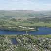
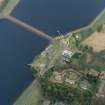
Glasgow Corporation Waterworks, Milngavie, Craigmaddie Reservoir


Reservoir (Period Unassigned)
Site Name Glasgow Corporation Waterworks, Milngavie, Craigmaddie Reservoir
Classification Reservoir (Period Unassigned)
Alternative Name(s) Strathblane Road; Glasgow Corporation Waterworks Loch Katrine Scheme
Canmore ID 158786
Site Number NS57NE 61
NGR NS 56394 75469
Datum OSGB36 - NGR
Permalink http://canmore.org.uk/site/158786


- Council East Dunbartonshire
- Parish New Kilpatrick (Bearsden And Milngavie)
- Former Region Strathclyde
- Former District Bearsden And Milngavie
- Former County Dunbartonshire
NS57NE 61 56394 75469
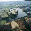
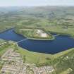
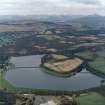
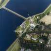
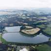
Craigmaddie Reservoir [NAT]
OS 1:2500 map, 1968.
Craigmaddie Reservoir [NAT]
OS 1:10,000 map, 1976.
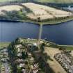
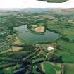
For associated Mugdock Reservoir (adjacent to W and NW), see NS57NE 63.
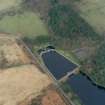
This reservoir was begun on the 1st May 1886 and completed on the 11th June 1896. The reservoir was brought into operation on the 1st January 1897 after geological problems necessitated the excavation of a deep trench to ensure that it was fully watertight.
Infomation from Jelle Muylle, engineer carrying out survey of sites and structures of the Loch Katrine Waterworks for RCAHMS, Historic Scotland funded, December 2007.
Construction (1886 - 1896)
J M Gale, engineer.
Aerial Photography (2 April 2003)
Aerial Photography (2 April 2003)
Aerial Photography (2 April 2003)
Aerial Photography (2 April 2003)
Aerial Photography (2 April 2003)
Aerial Photography (2 April 2003)
Aerial Photography (2 April 2003)
Aerial Photography (2 April 2003)
Aerial Photography (2 April 2003)
Aerial Photography (2 April 2003)
Aerial Photography (2 April 2003)
Aerial Photography (2 April 2003)
Aerial Photography (2 April 2003)
Aerial Photography (2 April 2003)
Aerial Photography (2 April 2003)
Aerial Photography (2 April 2003)
Aerial Photography (2 April 2003)
Aerial Photography (2 April 2003)
Aerial Photography (2 April 2003)
Project (2007)
This project was undertaken to input site information listed in 'Civil engineering heritage: Scotland - Lowlands and Borders' by R Paxton and J Shipway, 2007.
Publication Account (2007)
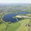
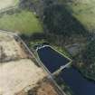
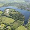
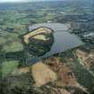
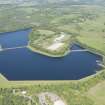
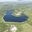
Craigmaddie Reservoir was first planned in 1880 to provide extra storage, but construction did not begin
until 1886 after the completion of road and stream diversions. An embankment 1592 yards long and 93 ft high
was required. Badly fissured rock was encountered in the cut-off trench to be filled with clay puddle to form an
impervious barrier. In one place it had to be excavated to a depth of 193 ft below ground level. The construction of this trench took more than six years and caused the resignation of the first contractor. The work was thereafter withdrawn from contract and executed by direct labour. The reservoir was finally completed in 1896 and cost about £337 000, more than two and a half times the original estimate. The reservoir has a water surface of 88 acres, a depth of 42 ft and a storage capacity of 700 million gallons. The works were designed and superintended by J. M. Gale, Engineer, Glasgow Water Department.
R Paxton and J Shipway 2007
Reproduced from 'Civil Engineering heritage : Scotland - Lowlands and Borders' with kind permission of Thomas Telford Publishers.

