
Brodie, Rodney's Stone


Cross Slab (Pictish), Ogham Inscribed Stone (Pictish), Pictish Symbol Stone (Pictish)
Site Name Brodie, Rodney's Stone
Classification Cross Slab (Pictish), Ogham Inscribed Stone (Pictish), Pictish Symbol Stone (Pictish)
Alternative Name(s) Dyke Parish Church; Brodie Castle Policies
Canmore ID 15529
Site Number NH95NE 3
NGR NH 98425 57665
NGR Description Removed from NH 990 584
Datum OSGB36 - NGR
Permalink http://canmore.org.uk/site/15529


- Council Moray
- Parish Dyke And Moy
- Former Region Grampian
- Former District Moray
- Former County Morayshire
Brodie, Rodney’s Stone, Moray, Pictish cross-slab
Measurements: H 1.90m +, W 1.05m tapering upwards to 0.95m, D 0.12m
Stone type: grey sandstone
Place of discovery: NH 9842 5766
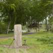
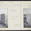
Present location: beside the driveway leading to Brodie Castle (National Trust for Scotland).
Evidence for discovery: found in 1781 in the old churchyard during digging for the foundations of a new parish church at Dyke. It was set up first in Dyke village and sometime before 1832 it was moved to the grounds of Brodie Castle. It had been re-used as a recumbent grave-slab, probably in the early eighteenth century, with face A uppermost.
Present condition: face A is very weathered, but face C is better preserved, and the base has been trimmed.
Description
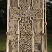
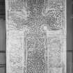
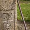
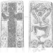
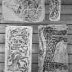
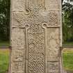
This rectangular slab is carved in relief on both broad faces within a flatband moulding. The moulding has been used for to incise three ogham inscriptions, one along the right-hand side of face A and two on either side of face C, which together represent the longest ogham inscription in Scotland. The inscription is largely unintelligible but includes the personal name Ethernan (Forsyth 1996). The question of whether it was contemporary with the relief carving remains open.
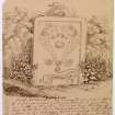
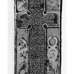
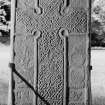
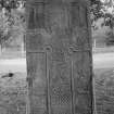
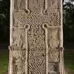
A cross with open circular armpits spans the length and breadth of face A, framed by a roll moulding. It is filled entirely with interlaced knotwork. There are badly weathered panels of zoomorphic ornament in the background to the cross, and those on either side of the shaft have a small recessed panel hollowed out to enable the letters AC and KB to be cut, when the slab was re-used as a recumbent grave-slab.
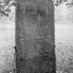
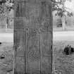
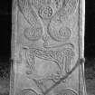
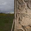
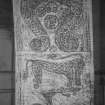
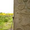
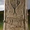
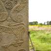
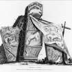
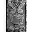
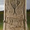
Face C bears three huge Pictish symbols one above the other: a pair of S-dragons, a Pictish beast facing right and a double disc and Z-rod, all heavily ornamented (the lower part of the Z-rod is missing). The S-dragons are guarding five smaller motifs, and their own internal decoration includes spirals, pellets and triquetra knots.
Date: ninth century.
References: Skene 1932; Stuart 1856, pls 22 & 23; ECMS pt 3, 132-5; Forsyth 1996, 139-59; Fraser 2008, no 151.
Compiled by A Ritchie 2016
Photographic Survey (1964)
Photographic survey of Rodney's Stone, Brodie, by the Scottish National Buildings Record in 1964.
Field Visit (23 August 1965)
Rodney's stone is as described above but the well weathered Ogham inscriptions are now only visible on two of the side angles near the base of the stone. The origin of the name, still in use, could not be ascertained: there is no local knowledge of the name 'Rotteny'.
Visited by OS (RD), 23 August 1965.
Desk Based Assessment (1965)
NH95NE 3 98425 57665 (removed from NH 990 584)
(NH 9842 5766) Sculptured Stone (NR)
called Rodney's Stone (NAT)
OS 6" map, 1906.
A Class II upright cross-slab of grey sandstone was found in 1781 during excavations for foundations for Dyke Church, which was constructed behind its pre-Reformation predecessor. The stone must have been in the graveyard of the old church (NH 990 584).
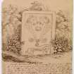
The stone was erected in Dyke village in commemoration of Rodney's victory over the Count de Grasse (Battle of the Saints - 1782) from which it received the name 'Rodney's Cross.' It was removed to the Park of Brodie a few years before 1842. (J G Callander has noted in the National Museum copy of Allen and Anderson 1903 "this stone was dug up by a gravedigger...locally known as Rotteny..and it was from this it got its name, not from Rodney's victory - authority of the late Rev. John MacEwan, minister of Dyke.)
The stone, erected on a modern base and held upright by wrought iron struts, is rectangular in shape, 6'4" high by 3'5" wide at the bottom and 3'2" wide at the top. It is sculptured in relief, with Ogham inscriptions down each of the four angles.
The front bears a cross with interlacing, and the back bears symbols including fish monsters, the elephant, double disc and z-rod.
Information from OS.
New Statistical Account (NSA) 1845 (M Aitken); Name Book 1870; J R Allen and J Anderson 1903.
Reference (1997)
Class II symbol stone (known as the Rodney Stone) showing the cross on the west face.On the east face are two fish monsters with an elephant and a double-disc and Z-rod below them. An Ogam inscription is seen on the north edge.
A Mack 1997.
Laser Scanning (2010)
NH 98425 57665 Situated in the NTS Brodie Estate, Rodney’s Stone is a Class II Pictish symbol stone, probably carved in the 8th century. Along three corners runs the longest known Scottish ogham inscription, extending for over 3m. Reused as a recumbent grave marker in perhaps the 16th or 17th century, it was rediscovered in 1781 during the excavation of foundations for a new parish church in the village of Dyke. Having been erected in Dyke the following year, it was subsequently moved to its present position in the 1820s/30s. Deri Jones Associates undertook a 3-D laser scan of the entire stone, with further, higher resolution scans of the ogham text/s and of strategic areas to act as a baseline for condition monitoring between March–December 2010. Data processing by Archaeoptics Ltd is ongoing; it is hoped that the high resolution data will allow a more complete transcription of the ogham to be created, elucidating some of the more heavily eroded letters.
Archive: The National Trust Scotland and RCAHMS (intended)
Funder: The National Trust for Scotland, Historic Scotland,
Hunter Archaeological and Historical Trust
Field Visit (September 2013 - April 2014)
The Class II Pictish Symbol Stone known as Rodney’s Stone is a Scheduled
Monument, scheduled in 1923 (SAM Index No. 1226, NH95NE0002, NMRS No. NH95NE 3, Canmore ID 15529; NGR NH984 576). The cross with interlace is carved onto the west side with the symbol-bearing side on the eastern face (as the stone is currently displayed).
Rodney’s Stone is an example of symbol stone that contains the enigmatic socalled Pictish beast amongst its symbols. Carved in relief are also the symbols of two paired sea monsters or fish (at top), and the double-disc and Z-rod (below). Along three corners is carved the longest Ogham inscription known from Scotland, extending over 3m (Fraser 2010, 112).
Shannon Fraser records that the stone had been reused as a recumbent grave marker, possibly in the 16th or 17th century, before it was rediscovered in 1781 during excavation for foundations of the new parish church at Dyke. The stone was erected at Dyke in 1782, as a memorial to Admiral Rodney’s victory over the French at the Battle of the Saintes off Dominica in 1782, but subsequently moved to its current position in the grounds of Brodie Castle, presumably in the 1820s to 1830s (Fraser 2010, 112). In the NSA Rev M Aitken writing on the Parishes of Dyke and Moy (1842) includes the first mention of Rodney’s Stone, noting that ‘near the northern approach to Brodie House is a sort of obelisk, about six feet high, forming a parallelogram … A few years ago it was removed to the Park of Brodie’. Watson (1868) describes the ‘obelisk’ to be ‘At the north end of the park’. It can be assumed that these writers are referring to the end of
the East drive as the most northerly of the three entrance drives and so the stone was moved here some time before 1842.
The stone, which is assessed as badly weathered, is dated by stylistic analysis
to the 8th century AD. To aid its conservation management the stone was
3D-laser-scanned by Deri Jones Associates for NTS. Higher resolution survey was undertaken in the areas of the Ogham text and of strategic areas to act as a baseline for condition monitoring. The scan was undertaken March–December 2010. Data processing by Archaeoptics Ltd is ongoing. It is hoped that the high resolution data will allow a more complete transcription of the ogham, elucidating some of the more heavily eroded letters (Fraser 2010, 112; also see Fraser 2008 and Canmore).
(BRD14 A17)
Information from NTS (SCS) February 2016

