
Edinburgh, Leith Docks, East Old Dock, Rennie's Entrance, Lock And Swing Bridge


Lock (19th Century), Swing Bridge (19th Century), Winch (19th Century)
Site Name Edinburgh, Leith Docks, East Old Dock, Rennie's Entrance, Lock And Swing Bridge
Classification Lock (19th Century), Swing Bridge (19th Century), Winch (19th Century)
Canmore ID 145466
Site Number NT27NE 57.33
NGR NT 26987 76693
Datum OSGB36 - NGR
Permalink http://canmore.org.uk/site/145466


- Council Edinburgh, City Of
- Parish Edinburgh (Edinburgh, City Of)
- Former Region Lothian
- Former District City Of Edinburgh
- Former County Midlothian
NT27NE 57.33 26987 76693
Formerly entered as NT27NE 283.
For (1996) watching brief at NT 2699 7670, see NT27NE 57.09.
For lock-keeper's lodge (NT 27006 76679), see NT27NE 57.43.
Swing-Bridge [NAT]
OS 1:1250 map, 1974.
Lock [NAT]
Swing-bridge [NAT]
OS (GIS) ep. 4.
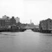
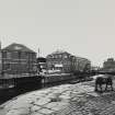
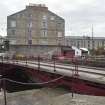
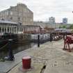
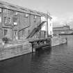
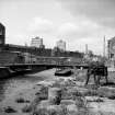
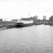
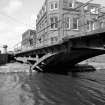
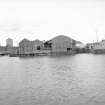
Only the East Dock entrance (NT57NE 57.33) can now be seen of the Rennie's Old Docks at Leith. The West and East Old Docks (NT27NE 57.32 and NT27NE 57.41 respectively) were apparently infilled by 1974, when their area is indicated as an open space on the OS 1:1250 map. This area is now occupied by the Victoria Quay building (NT27NE 861) of the Scottish Executive (formerly Scottish Office).
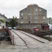
The available map evidence (1974) indicates that the swing bridge has swinging-recesses on both sides.
Information from RCAHMS (RJCM), 14 February 2006.
Construction (1800 - 1806)
Project (2007)
This project was undertaken to input site information listed in 'Civil engineering heritage: Scotland - Lowlands and Borders' by R Paxton and J Shipway, 2007.
Publication Account (2007)
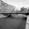
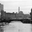
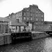
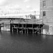
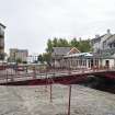
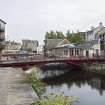
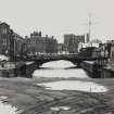
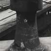
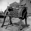
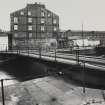
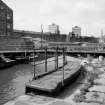
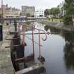
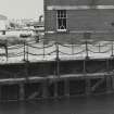
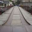
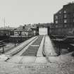
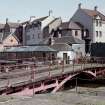
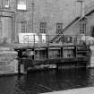
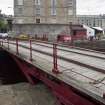
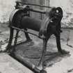
The impressive entrance lock of 1806 to the East and West Docks is 145 ft long by 34 ft wide and 23 ft deep and similar to the entrance from the Thames to London Docks of about the same date, also engineered by Rennie. This fine example of his practice is located at the east end of the no longer existing East Dock, joining to the old inner harbour on the river course. The timber lock gates, slightly curved in plan, and now disused were operated by a chain and winch system. The east gates probably date from an improvement by James Leslie in ca.1846 and the west gates from 1922.
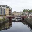
There have been two turn bridges at this location; the first of timber dating from 1806 and the second, the present iron structure, erected in ca.1850. This bridge is 15 ft wide in two halves giving a clear span of 35 ft 6 in. with a skew of approximately 858. The distance between the centres of 160 rotation is 56 ft and the overall length 87 ft 3 in. The deck is timber with wrought-iron handrails and iron cart-wheel channels. Structurally the bridge is a three pin arch with six cast-iron ribs. It is opened by raising pivoted sections of the arch members adjacent to the springings by means of winches built into the deck; this frees the two halves of the bridge to rotate in plan. The drive mechanism is operated through capstans turning pinions which engage with racks fixed to the swing sections below road level. The eastern pier extension of 1826–29 began on the east side of the river opposite and north of the old dock entrance.
R Paxton and J Shipway 2007
Reproduced from 'Civil Engineering heritage: Scotland - Lowlands and Borders' with kind permission of Thomas Telford Publishers.

