
Pricing Change
New pricing for orders of material from this site will come into place shortly. Charges for supply of digital images, digitisation on demand, prints and licensing will be altered.
Quarterside Of Lipney


Farmstead (Medieval) - (Post Medieval)
Site Name Quarterside Of Lipney
Classification Farmstead (Medieval) - (Post Medieval)
Canmore ID 145092
Site Number NS89NW 83.01
NGR NS 8451 9784
Datum OSGB36 - NGR
Permalink http://canmore.org.uk/site/145092


- Council Stirling
- Parish Logie (Stirling)
- Former Region Central
- Former District Stirling
- Former County Stirlingshire
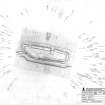
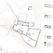
Measured Survey (July 1997)
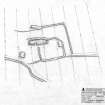
RCAHMS surveyed the farmstead at Quarterside of Lipney with plane-table and alidade in July 1997 at a scale of 1:250. The plan was redrawn in ink before colour, scale and annotation were added in vector graphics software. The resultant plan was published at a scale of 1:500 (RCAHMS 2001, Fig. 28).
Field Visit (19 May 1997)
NS89NW 83.01 8451 9784
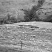
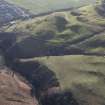
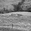
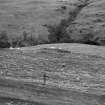
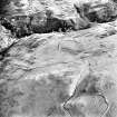
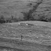
This farmstead is situated on a terrace on the N bank of an unnamed burn, and comprises the footings of at least five buildings and four enclosures, belonging to three phases of construction. The buildings are ranged around a trapezoidal enclosure which may have been a stack yard.
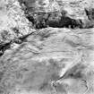
The phasing in the construction of the farmstead is evident in the buildings along the N side of the yard. A turf- and stone-walled building is overlain by the E end of a stone founded building. The W end of this later building has been inserted across the end of a further stone founded building, which is likely to have remained in use and probably post-dates the turf and stone walled building. In its latest phase of occupation the farmstead comprises the faced-rubble footings of two buildings (MENS97 65, 67) lying along the N and S sides of the enclosure. The context of the extensively robbed stone footing of a building (MENS97 66) overlain by the W side of the enclosure wall is not clear. The building along the N side of the enclosure exhibits two distinct episodes of construction in stone, and also overlies the grassed-over footings of an earlier turf and stone building. In its final manifestation the stone walled building comprises two interconnected compartments, each with an entrance on the S. The W compartment has been a free-standing structure measuring at least 7m by 3.8m internally. At some point the E end has been removed and the E compartment has been built, measuring 8m by 3.6m internally. It may have been a byre, with the drain emptying out though the E end. That the W structure remained in use is indicated by a connecting door through the gable end. This phasing in the construction of the building is mirrored in a recut of the drain which runs along the N side of the building. At the E end of the stone walled building, the stub of an earlier building, aligned on the same axis, extends for 6m to the E, and 3.4m across within a low grassy bank. The drain along the N side of the stone walled building also cuts the building and the dished interior of the earlier building may have served as a midden. The S side of a square enclosure extends to the N of the stone-walled building, and may belong in the same phase of construction as the earlier grass-covered building. The building to the S (MENS97 67) measures 6.1m by 3.7m internally, with an entrance into the enclosure on the N. A hut (MENS97 64) measuring 3.5m by 3.3m within a stony bank lies to the N of the farmstead.
The stack yard contains two stony mounds which may have been stack-stands. To the E there are two conjoined trapezoidal enclosures which on the basis of the build up of soil in the interior may have been gardens. A mound in the SW angle of the northerly of the two may have been a midden. A hollow trackway cuts across the ridge to the W, on two consecutive lines.
The farmstead is first documented in 1730 when repairs were carried out, the account (SRO, RH 15/115/1/2 bundle G) of which indicates that it was stone-walled and may correspond to the surviving stone-walled buildings. References to the site cease in the latter part of the 18th century and the farmstead is not shown on 1st edition of OS 6-inch map (Perthshire and Clackmanannshire 1865-6, sheet cxxxiii; Parts of Stirlingshire 1865-6, sheets x and xi) or an early 19th century estate plan (SRO, RHP 20943).
(MENS97 64-8)
Visited by RCAHMS (DCC) 19 May 1997

