|
Manuscripts |
MS 731/19 |
Records of the Royal Commission on the Ancient and Historical Monuments of Scotland (RCAHMS), Edinbu |
Afforestable Land Survey field database (Menstrie Glen survey, 1997). Held as attribute table in GIS and in Oracle Field/AP table. Please see DX001444 |
1997 |
Item Level |
|
|
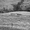
Photographs and Off-line Digital Images |
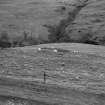
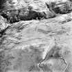
D 59276 |
Records of the Royal Commission on the Ancient and Historical Monuments of Scotland (RCAHMS), Edinbu |
View of hut near farmstead. |
1998 |
Item Level |
|
|
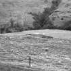
Photographs and Off-line Digital Images |
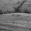
D 59275 |
Records of the Royal Commission on the Ancient and Historical Monuments of Scotland (RCAHMS), Edinbu |
View of hut near farmstead. |
1998 |
Item Level |
|
|
Photographs and Off-line Digital Images |
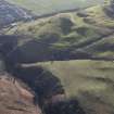
D 20765 |
RCAHMS Aerial Photography |
Oblique aerial view of Quarterside of Lipney centred on the remains of a farmstead with field-systems, head-dyke and rig adjacent, taken from the NW. |
12/12/1997 |
Item Level |
|
|
Photographs and Off-line Digital Images |
D 20766 |
RCAHMS Aerial Photography |
Oblique aerial view of Quarterside of Lipney centred on the remains of a farmstead with field-systems, head-dyke and rig adjacent, taken from the NW. |
12/12/1997 |
Item Level |
|
|
Prints and Drawings |
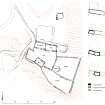
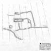
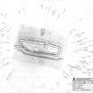
DC 48835 |
Records of the Royal Commission on the Ancient and Historical Monuments of Scotland (RCAHMS), Edinbu |
Quarterside of Lipney - Survey drawing: Plan of farmstead. |
1997 |
Item Level |
|
|
Prints and Drawings |
DC 48836 |
Records of the Royal Commission on the Ancient and Historical Monuments of Scotland (RCAHMS), Edinbu |
Quarterside of Lipney - Survey Drawing: Plan of building and enclosure. |
1997 |
Item Level |
|
|
Prints and Drawings |
DC 48837 |
Records of the Royal Commission on the Ancient and Historical Monuments of Scotland (RCAHMS), Edinbu |
Quarterside of Lipney - Survey Drawing: Plan of building. |
18/6/1997 |
Item Level |
|
|
Prints and Drawings |
DC 48849 |
Records of the Royal Commission on the Ancient and Historical Monuments of Scotland (RCAHMS), Edinbu |
Survey Drawing: Plan of buidling and enclosure. |
1997 |
Item Level |
|
 |
On-line Digital Images |
SC 1346654 |
Records of the Royal Commission on the Ancient and Historical Monuments of Scotland (RCAHMS), Edinbu |
Map showing distribution of settlements in Menstrie Glen before the 1760s with head-dykes and cultivated ground. Fig 11 in "Well shelterd & watered" Menstrie Glen, a farming landscape near Stirling. |
2001 |
Item Level |
|
 |
On-line Digital Images |
SC 1346665 |
Records of the Royal Commission on the Ancient and Historical Monuments of Scotland (RCAHMS), Edinbu |
Publication drawing; plan of farmstead, Quarterside of Lipney. |
1997 |
Item Level |
|
 |
On-line Digital Images |
SC 1346666 |
Records of the Royal Commission on the Ancient and Historical Monuments of Scotland (RCAHMS), Edinbu |
Illustration showing layout of farmsteads in the Menstrie Glen. Fig 31 in "Well shelterd & watered" Menstrie Glen, a farming landscape near Stirling. |
|
Item Level |
|
 |
On-line Digital Images |
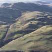
DP 175956 |
RCAHMS Aerial Photography Digital |
General oblique aerial view of Menstrie Glen with Dumyat beyond, looking W. |
7/2/2014 |
Item Level |
|
 |
On-line Digital Images |
DP 175958 |
RCAHMS Aerial Photography Digital |
Oblique aerial view of Quarterside of Lipney, looking SSW. |
7/2/2014 |
Item Level |
|
 |
On-line Digital Images |
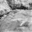
SC 1440962 |
Records of the Royal Commission on the Ancient and Historical Monuments of Scotland (RCAHMS), Edinbu |
View of hut near farmstead. |
1998 |
Item Level |
|
 |
On-line Digital Images |
SC 1440963 |
Records of the Royal Commission on the Ancient and Historical Monuments of Scotland (RCAHMS), Edinbu |
View of hut near farmstead. |
1998 |
Item Level |
|
 |
On-line Digital Images |
SC 1727222 |
RCAHMS Aerial Photography |
Oblique aerial view of Quarterside of Lipney centred on the remains of a farmstead with field-systems, head-dyke and rig adjacent, taken from the NW. |
12/12/1997 |
Item Level |
|
 |
On-line Digital Images |
SC 1727223 |
RCAHMS Aerial Photography |
Oblique aerial view of Quarterside of Lipney centred on the remains of a farmstead with field-systems, head-dyke and rig adjacent, taken from the NW. |
12/12/1997 |
Item Level |
|
|
Digital Files (Non-image) |
DX 001444 |
Records of the Royal Commission on the Ancient and Historical Monuments of Scotland (RCAHMS), Edinbu |
RCAHMS Structures Database - Menstrie Glen |
1997 |
Item Level |
|
|
Digital Files (Non-image) |
TM 000560 |
Records of the Royal Commission on the Ancient and Historical Monuments of Scotland (RCAHMS), Edinbu |
Zip file containing all survey linework collected during the RCAHMS Afforestable Land Survey of Menstrie Glen survey (1997). |
1997 |
Item Level |
|
 |
On-line Digital Images |
SC 2210294 |
Records of the Royal Commission on the Ancient and Historical Monuments of Scotland (RCAHMS), Edinbu |
Quarterside of Lipney - Survey Drawing: Plan of building and enclosure. |
1997 |
Item Level |
|
 |
On-line Digital Images |
SC 2210295 |
Records of the Royal Commission on the Ancient and Historical Monuments of Scotland (RCAHMS), Edinbu |
Quarterside of Lipney - Survey Drawing: Plan of building. |
18/6/1997 |
Item Level |
|
 |
On-line Digital Images |
SC 2475539 |
Records of the Royal Commission on the Ancient and Historical Monuments of Scotland (RCAHMS), Edinbu |
View of hut near farmstead. |
1998 |
Item Level |
|
 |
On-line Digital Images |
SC 2475540 |
Records of the Royal Commission on the Ancient and Historical Monuments of Scotland (RCAHMS), Edinbu |
View of hut near farmstead. |
1998 |
Item Level |
|


