
Following the launch of trove.scot in February 2025 we are now planning the retiral of some of our webservices. Canmore will be switched off on 24th June 2025. Information about the closure can be found on the HES website: Retiral of HES web services | Historic Environment Scotland
Old Petty


Motte (Medieval)
Site Name Old Petty
Classification Motte (Medieval)
Alternative Name(s) Glebe Cottage, Motte; Petty Motte
Canmore ID 14218
Site Number NH74NW 3
NGR NH 73826 49866
NGR Description NH 73826 49866 and NH 73631 49769
Datum OSGB36 - NGR
Permalink http://canmore.org.uk/site/14218


- Council Highland
- Parish Petty
- Former Region Highland
- Former District Inverness
- Former County Inverness-shire
NH74NW 3 7383 4987 and 7363 4977
(NH 7383 4987) Tumulus (NR),
(NH 7363 4977) Tumulus (NR)
OS 6" map, Inverness-shire, 2nd ed., (1907)
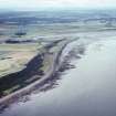
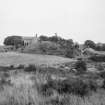
There are two mounds to the W of Petty Church [St Columba's Church: NH74NW 55], 150' in circumference at the base, 120' at the top and 42' high. In 1875, while a man was ploughing, his horse fell into an underground structure "at the very base" of one of them.
G Anderson 1831; Jolly 1885; ISSFC 1885.
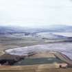
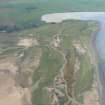
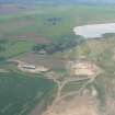
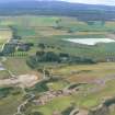
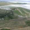
At NH 7383 4987 is a motte scarped from a natural sand-hill. It measures c. 45.0m overall by c. 5.5m high and has a level oval top measuring about 20.0m NE-SW by 16.0m.
Revised at 1/2500 (OS [ECG] 26 April 1962).
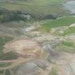
The mound, at NH 7363 4977, is a natural sand-hill of similar proportions. The N and E sides appear to have been steepened, but this is probably the result of quarrying sand which has mutilated the surrounding area.
No evidence is to be seen of the underground structure mentioned by Anderson and Jolly.
Visited by OS (ISS) 30 March 1973.
Air photographs, taken by Jill Harden in 1989, are in Inverness Museum (8905.02-04 INVMG).
Information from J Harden, 1989.
Scheduled as 'Glebe Cottage, motte 30m NNE of... a motte of medieval date, visible as a grass-covered mound. It lies 1km from the S shore of the Moray Firth, within a private garden and between a vehicle track and [a] burial ground.'
Information from Historic Scotland, scheduling document dated 19 July 2011.
Field Visit (19 September 1943)
This site was recorded as part of the RCAHMS Emergency Survey, undertaken by Angus Graham and Vere Gordon Childe during World War 2. The project archive has been catalogued during 2013-2014 and the material, which includes notebooks, manuscripts, typescripts, plans and photographs, is now available online.
Information from RCAHMS (GF Geddes) 12 November 2014.
Typescript, v1, 75-76
Manuscript MS 36, 165-167
Notebook MS 124/3
Field Visit (April 1979)
Old Petty NH 738 498 NH74NW 3
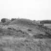
This motte has been scarped from a natural sand-hill 50m WSW of Petty church. It rises about 6m to a level summit measuring 18.6m by 14.9m and may have been the site of the 12th-century castle of Freskyn de Moravia.
RCAHMS 1979, visited April 1979
Meldrum 1975, 144
Petty NH 736 497 NH74NW 3
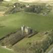
What may be a motte scarped from a natural sand-hill stands 200m WSW of Old Petty. The mound rises to a height of about 8m arid has a rounded summit measuring about 14m in diameter, while to the N and NE of the mound there are traces of a possible ditch.
RCAHMS 1979, visited April 1979

