
Pricing Change
New pricing for orders of material from this site will come into place shortly. Charges for supply of digital images, digitisation on demand, prints and licensing will be altered.
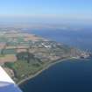
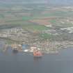
Invergordon Castle


Castle (Medieval)
Site Name Invergordon Castle
Classification Castle (Medieval)
Alternative Name(s) Inverbreakie Castle
Canmore ID 13621
Site Number NH66NE 16
NGR NH 69852 69653
Datum OSGB36 - NGR
Permalink http://canmore.org.uk/site/13621


- Council Highland
- Parish Rosskeen
- Former Region Highland
- Former District Ross And Cromarty
- Former County Ross And Cromarty
NH66NE 16 c. 6984 6965
(NH 6984 6965) Invergordon Castle (NAT)
OS 6" map, Ross and Cromarty, 1st ed., (1872).
ARCHITECT: Alexander Ross c1873.
(Undated) information in NMRS.
The original name of Invergordon Castle was 'Inverbreakie Castle', which is mentioned in the 13th century. The change of name took place on the acquisition of the estate by Sir Wm Gordon at the beginning of the 18th century.
The old castle was destroyed by fire and was replaced by a modern mansion in 1872, which was demolished in 1928.
Anon 1936; Anon 1957.
Field Visit (September 1978)
lnvergordon Castle NH 698 696 NH66NE 16
This castle, which is said to have been in existence in the 13th century, was formerly known as lnverbreakie. It was replaced by a 19th-century mansion, now demolished.
RCAHMS 1979, visited September 1978

