
Following the launch of trove.scot in February 2025 we are now planning the retiral of some of our webservices. Canmore will be switched off on 24th June 2025. Information about the closure can be found on the HES website: Retiral of HES web services | Historic Environment Scotland
Strath Sgitheach


Cairnfield (Prehistoric)(Possible), Hut Circle(S) (Prehistoric)
Site Name Strath Sgitheach
Classification Cairnfield (Prehistoric)(Possible), Hut Circle(S) (Prehistoric)
Canmore ID 12924
Site Number NH56SW 14
NGR NH 52384 63304
NGR Description NH 5238 6330, NH 5239 6330, NH 5240 6328
Datum OSGB36 - NGR
Permalink http://canmore.org.uk/site/12924


- Council Highland
- Parish Dingwall
- Former Region Highland
- Former District Ross And Cromarty
- Former County Ross And Cromarty
NH56SW 14 524 632.
Centred at NH 524 632 on an almost level part of the hillside is a settlement of three hut circles, plus a probable hut ('A' - 'D').
'A' is a small heather-covered hut measuring 8.5 m SE - NW x 7.0 m within a slight wall of 1.8 m average spread. The entrance is in the SE.
'B' is noticeably larger and stronger built than 'A' being 13.0m SE - NW x 11.0 m within a wall of 2.5 m average spread, somewhat mutilated in the NW. An outer facing stone lies at the E side of the entrance in the SE.
'C' is 8.5 m E - W x 7.5 m within a wall of 2.0 m average spread. The entrance is in the E.
Immediately to the ENE of 'C' is an enclosure 'D' probably a hut circle though in a much poorer and rougher condition than 'C'. It measures approximately 9.9 m SE - NW x approximately 7.0 m within a wall of indeterminate width. Some probable facing stones lie to the S of the entrance, in the SE.
130 metres E of 'B' is a sub-rectangular feature ('X' on the field sheet) about 8.0 m in diameter within a turf-covered bank. Its condition is too amorphous for definite classification.
A few scattered clearance heaps are the only evidence of contemporary cultivation in the area.
Surveyed at 1:10 000.
Visited by OS (J B) 16 November 1976.
Field Visit (September 1978)
Strath Sgitheach 3 NH 524 632 NH56SW 14
This group of at least three hut-circles and scattered cairns stands in improved pasture.
RCAHMS 1979, visited September 1978
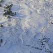
Aerial Photography (January 2010)
NH 524 632 (centred on) A concentration of hut circles,
outlined against a light snow cover, was observed during
a private flight in January 2010. Four hut circles had been
recorded, but at least ten can be noted in the immediate
area.
Archive: Highland HER

