
Pricing Change
New pricing for orders of material from this site will come into place shortly. Charges for supply of digital images, digitisation on demand, prints and licensing will be altered.
Glasgow, Yoker Power Station


Power Station (20th Century)
Site Name Glasgow, Yoker Power Station
Classification Power Station (20th Century)
Canmore ID 128411
Site Number NS56NW 84
NGR NS 5107 6866
Datum OSGB36 - NGR
Permalink http://canmore.org.uk/site/128411


- Council Glasgow, City Of
- Parish Renfrew (City Of Glasgow)
- Former Region Strathclyde
- Former District City Of Glasgow
- Former County Lanarkshire
NS56NW 84 5107 6866.
A power station is visible at this location on a Luftwaffe aerial photograph held in NMRS and RAF vertical aerial photographs (106G/UK/1028: 4008 and 4009, 26 November 1945).
Information from RCAHMS (KM) 26 March 1998.
Desk Based Assessment (14 June 2017)
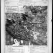
Nothing is now visible of Yoker Power Station, which closed in 1976, and its site is now occupied by housing. It was built in 1905 on the north bank of the River Clyde in the Yoker area of Glasgow, adjacent to the Renfrew Ferry (NS56NW 527), by the British Thomson Houston Company. It is depicted on the 3rd edition of the OS 25-inch map (Renfrewshire 1913, Sheet 008.03). The station was later acquired by the Clyde Valley Electric Power Company and, in 1955, by the South of Scotland Electricity Board. Output rose from 4000 kilowatts in 1905 to a peak of 100,000 kilowatts by 1966, when the coal-fired station had eight high-pressure boilers.
Information from HES Survey and Recording (AMcC) 14 June 2017.

