
Following the launch of trove.scot in February 2025 we are now planning the retiral of some of our webservices. Canmore will be switched off on 24th June 2025. Information about the closure can be found on the HES website: Retiral of HES web services | Historic Environment Scotland
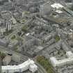
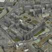
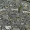
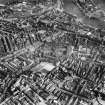
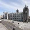
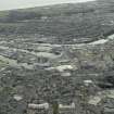
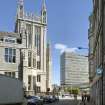
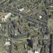
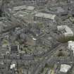
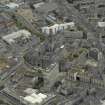
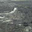
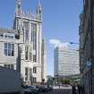
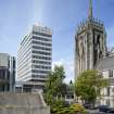
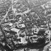
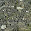
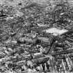
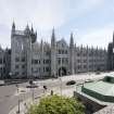
Aberdeen, Broad Street, University Of Aberdeen, Marischal College


College (16th Century)
Site Name Aberdeen, Broad Street, University Of Aberdeen, Marischal College
Classification College (16th Century)
Alternative Name(s) Gallowgate; Greyfriars Church; Mitchell Hall; Mitchell Tower; Aberdeen University; Museum
Canmore ID 125349
Site Number NJ90NW 359
NGR NJ 94240 06535
Datum OSGB36 - NGR
Permalink http://canmore.org.uk/site/125349


First 100 images shown. See the Collections panel (below) for a link to all digital images.
- Council Aberdeen, City Of
- Parish Aberdeen
- Former Region Grampian
- Former District City Of Aberdeen
- Former County Aberdeenshire
NJ90NW 359 94240 06535
For (underlying) Franciscan Friary (Greyfriars Church or Grey Friar's Monastery), see NJ90NW 26.
Air photographs, Marischal College and City Chambers: AAS/00/08/CT, AAS/00/12/CT and AAS/00/12/G30/13.
NMRS, MS/712/100.
NJ 9425 0650. A watching brief was undertaken in March 2005 during engineering test holes in Marischal College (NJ90NW 359), in the area of the former Greyfriars Priory (NJ90NW 26). The work revealed two stretches of walling of unknown date.
Full report lodged with Aberdeen SMR and NMRS.
Sponsor: Ramsay and Chalmers, Consulting Engineers.
NJ90NW 359 94240 06535
NMRS REFERENCE: NOVEMBER 2000
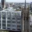
Architect: A. Marshall Mackenzie. 1903.
William Adam? 1741 as architect for original building.
Archibald Simpson (several schemes not carried out) 1844
EXTERNAL REFERENCE:
Aberdeen Public Library, Reference Department - slides of Mitchell Hall & East window
Aberdeen Public Library - Lithograph by Leith & Smith showing bldgs 1844
SMT Magazine, May 1951
SMT Magazine, December, 1930 - lithograph of East view.
(Undated) information in NMRS.
Publication Account (1997)
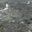
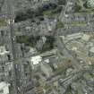
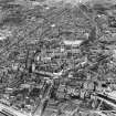
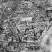
In 1593, George Keith, Earl Marischal, founded the University of Marischal College, perhaps in reaction to lack of change in King's College, Old Aberdeen, and in order to operate a new reformed syllabus at New Aberdeen. The college was endowed with revenues from the Dominican and Carmelite properties, and was housed in the former Franciscan Friary on the east side of Broad Street. The buildings were altered on several occasions until 1836-44 when old buildings were removed to form the eastern side of the present quadrangle, designed by Archibald Simpson. The existing west side was constructed between 1893 and 1906, to designs by A Marshall Mackenzie, and necessitated the removal of the old Greyfriars Church (see above). The rebuilding provided a new examination hall, as well as an extension to the central tower. The work left Marischal College the second largest granite building in the world (after the Escorial in Madrid), and the granite was used in ways that previously had not been thought possible. The Marischal College remained an independent university until 1860, when it united with King's College, Old Aberdeen.
Information from ‘Historic Aberdeen: The Archaeological Implications of Development’ (1997).
Watching Brief (1 January 2011 - 6 April 2011)
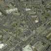
NJ 9424 0653 (centred on) Conversion of Marischal College into the new headquarters of Aberdeen City Council has included a range of archaeological work, and the final stages of this work were carried out 1 January–6 April 2011. A watching brief undertaken during groundwork associated with excavations of the Broad Street frontage of the building, drainage excavations to the W, and new sewage installations behind the building recorded 29 features and 6 finds.
The most recent features were an area of wooden cassies and a low boundary wall, which probably dated to the redesigning of Marischal College frontage in the early 20th century. A brick-built rectangular structure was identified as a personnel access chamber or manhole cover of probable Victorian date. Walls, located to the rear of the building, must have related to tenement buildings that are depicted on the OS map of 1865, but not seen on Milne’s Plan of 1789. A construction date of between 1789 and 1865 ties in neatly with glass and jar finds recovered during excavations. The majority of the features (seven) located in the Broad Street frontage area were walls and drains associated with the cellars of tenement buildings. These were depicted on Milne’s Plan of 1789 but not on Patterson’s earlier plan of 1746, indicating that these features date from somewhere between 1746 and 1789, although later alterations may have occurred. The earliest deposits were recorded from the drainage excavations on Littlejohn Street, and it is likely that the organic material was from part of a medieval midden known to exist in this area.
Archive: Aberdeen City Council
Funder: Aberdeen City Council
Aberdeen City Council Art Gallery and Museum Service, 2011
Information also reported in Oasis (aberdeen3-113456) 11 November 2011

