
Fairburn Tower


Tower House (Medieval)
Site Name Fairburn Tower
Classification Tower House (Medieval)
Alternative Name(s) Fairburn Castle
Canmore ID 12479
Site Number NH45SE 1
NGR NH 46952 52356
Datum OSGB36 - NGR
Permalink http://canmore.org.uk/site/12479


- Council Highland
- Parish Urray (Ross And Cromarty)
- Former Region Highland
- Former District Ross And Cromarty
- Former County Ross And Cromarty
NH45SE 1 46952 52356
(NH 4693 5235) Fairburn Tower {NR} (remains of)
OS 6" map, (1971)
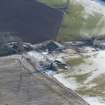
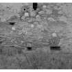
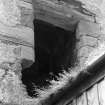
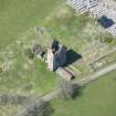
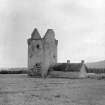
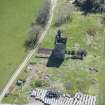
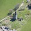
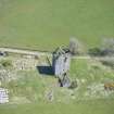
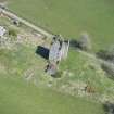
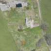
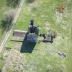
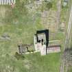
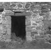
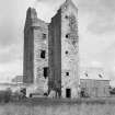
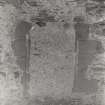
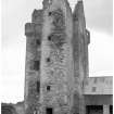
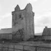
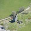
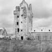
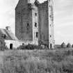
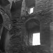
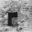
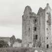
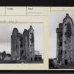
The ruin of a 16th-17th century tower-house, standing to the wall-head, high on a long ridge. It dates from two periods, the original having been a massive oblong keep with crow-steps and angle-turrets, to the SE of which a stair tower four storeys and a garret in height has been added in the early 17th century. The entrance, in the S face of this tower, is defended by gun-loops and shot-holes. The original entrance to the keep has been at first floor level. There has been a courtyard to the S and W. The tower, of rough harled masonry, was a stronghold of the MacKenzies.
D MacGibbon and T Ross 1889; N Tranter 1970
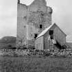
Fairburn Tower, a roofless 16th century tower house, is generally as described. The barrel-vaulted basement is still intact. There is no trace of the alleged courtyard. Only some toothing at the SE corner of the 17th century addition suggests there may have been one. Later, now ruinous, domestic buildings are attached to the W side of the tower and a wooden farm building to the E side.
Visited by OS (J B) 2 May 1975
No change.
Visited by RCAHMS (JRS) March 1989.
NH 45609 54077 to NH 45672 54103 A small watching brief was undertaken in September 2003 to the N of two cists found in 1972/3 (NH45SE 4) as part of a water mains renewal project. No archaeological deposits or features were revealed. As the site was part of a former river course, the nearby cists were probably situated on a knoll overlooking the river.
NH 46983 52291 to NH 46973 52422 A small watching brief was undertaken to the E of Fairburn Tower (NH45SE 1) in December 2003. No archaeological deposits or features were revealed.
Reports lodged with Highland SMR and the NMRS.
Sponsor: Halcrow Group Ltd for Scottish Water.
S Farrell 2004.
Photographic Record (3 September 1943)
13 photographs were taken by Angus Graham as part of the Emergency Survey.
Standing Building Recording (May 2018)
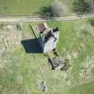
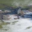
NH 46952 52356 A comprehensive building survey was undertaken at Fairburn Tower in May 2018. The survey involved a combination of digital and hand-drawn survey; UAV captured imagery and photogrammetry were used to create a 3D model of the tower, from which orthographic projections were produced to create elevations and plans.
The survey has considerably progressed the understanding of the architectural evolution of the standing remains, including the phasing of the upper levels of the tower. Many additional architectural details were identified, which have added to the understanding of the tower and its planning and internal arrangement in particular.
Early tower – The core structure at Fairburn is a well-preserved tower-residence of the mid-16th century, notable for its austere external appearance with its profusion of gun-ports and shot holes at lower levels and, in contrast, for the quality and rich detailing of the residential accommodation within the three upper floors.
The early tower at Fairburn was expensive in its execution and notable in its sophistication. The unusual array of gun-ports and loops demonstrates that considerable resources were expended on the tower. These were positioned for a greater degree of defensive capability than is seen on most towers at this date.
The likely builder was Murdoch MacKenzie, a man with very significant connections as a Gentleman of the Bedchamber at the court of James V. Though of modest scale, Fairburn’s architectural details likely take their inspiration from current building works in court and aristocratic circles and can probably be very beneficially compared with surviving examples.
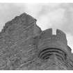
17th century works – In the earlier 17th century or thereabouts the tower saw significant reordering so as to improve its accommodation and functional amenity. At the same time reconstruction of the top of the original tower provided a full storey of usable space and also included the introduction of bartizan towers at the SW and NE angles, the introduction of fine wall-head detailing, dormer windows and crow-stepped gables. These works are generally well-preserved, of accomplished architectural detail and are in large part responsible for the overall architectural character of the tower as it appears today.
Kitchen range (?c1700) – The kitchen range, likely to be of later 17th- or early 18th-century date, was clearly an addition made during the continuing occupation of the tower by its higher status inhabitants. It is a significant survival, comparatively complete, that preserves important individual features such as the broad arched kitchen fireplace opening and evidence for cruck-framing.
Later occupation (repairs) – The continuing use of the tower is indicated by various minor interventions, modifications and blockings around the structure but especially by attempts to arrest the structural movement of the stair tower. This had been only minimally tied in to the S wall of the early tower and had clearly started to disengage from its fabric, with major cracks forming at the junction.
Occupation of the tower appears to have ceased by the early 19th century, probably following the removal of the Mackenzies to the newly-built Muirton House (now Fairburn House), c1800. Ruination may have been the result of deliberate though partial dismantling, perhaps the recovery of structural timber and, more certainly, the salvage of the stones of the turnpike stair. The vaulted lower stage of the tower was evidently put to agricultural use by the breaking-through of an entrance from the yard area on the S side, likely for use as a byre.
Removal of the stones of the stair resulted in the further destabilisation of the stair tower, with a major structural crack developing at the centre of the S side.
Likely in the 1860s or 70s a series of repairs were made to the tower that seem to have responded both to a concern to prevent structural collapse and with an antiquarian eye.
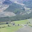
The remaining components of the Fairburn Tower site would have typically been arranged within a walled compound with gated entry (a Barmkin). At Fairburn it seems likely that this existed to the S and SW of the tower; an entrance possibly existed on the E side.
Archive: NRHE (intended)
Funder: The Landmark Trust
Thomas Addyman and Kenneth Macfadyen – Addyman Archaeology
(Source: DES Volume 19)
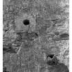
Earth Resistance Survey (8 November 2019 - 9 November 2019)
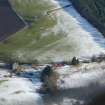
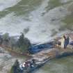
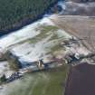
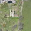
NH 46952 52356 A geophysical survey was undertaken within a field (0.25ha) surrounding Fairburn Tower, on 8 and 9 November 2019. The Tower is a Category A Listed square tower, dating from the late 16th to early 17th century, situated W of Muir of Ord. Although it has been assumed that the tower had a courtyard to the S and W, there is no trace of this courtyard visible today. However, toothing at the SE corner of the 17th century addition suggests there may have been one.
Resistance survey at 0.5 x 0.5m was carried out to map possible structural remains associated with the extant tower over all available areas within the field.
A range of responses were recorded across the survey area. Some small areas could not be surveyed due to bushes and trees and dense areas of rubble/stone. In addition, trenches associated with geotechnical test pits were open at the time of survey. However, this did not detract from the overall results of the geophysical survey.
Two very well-defined high resistance anomalies have been recorded immediately to the NW of the later domestic structure to the W of the tower. The well-defined limits of the anomalies suggest these may indicate in situ structural remains. Although a modern origin is possible, some documentary evidence suggests that a courtyard associated with the tower existed to the W and S of the tower, and as a result an archaeological origin, contemporary with the tower, cannot be dismissed.
A concentration of broad rectilinear anomalies has been recorded in the S of the survey area. Taken together these anomalies give the impression of a collection of buildings, potentially associated with a courtyard, some 35m to the S of the Tower, although no clearly defined courtyard walls leading off the tower are apparent in the data. However, such an interpretation is tentative given the rubble spreads across the site and the lack of archaeological deposits revealed during the excavation of geotechnical test pits
Archive: Rose Geophysical Consultants
Funder: Addyman Archaeology
Susan Ovenden – Rose Geophysical Consultants
(Source: DES Vol 21)
Field Visit (January 2020 - March 2020)
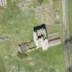
NH 46952 52356 Monitoring of the excavation of scaffolding footings was undertaken at Fairburn Tower (Canmore ID: 12479) from January to March 2020. This was in advance of, and in association with, works being undertaken to repair and bring into reuse the tower and adjacent structures. The site comprises a regularly built tower, almost square in plan, erected in the mid- 16th century by the Mackenzie family. In the early 17th century, the tower was remodelled with the addition of a full upper storey with bartizans and crow-stepped gables, a four-storey stair tower with garret on its S side. A single-storied kitchen wing was added to the W of the tower in c1700. The structure is a Category A Listed Building (LB14030) and lies within the wider Fairburn Estate, whose existing landscape layout dates mainly from the late 18th/ early 19th century, registered in the Inventory of Gardens and Designed Landscapes (GDL00174).
Monitoring was carried out over a series of groundwork activities
between January and March 2020, up to the time of the site shut- down necessitated by the outbreak of the COVID 19 virus, at which point all works were temporarily suspended.
In preparation for the erection of a general scaffold around the exterior of the tower, 22 trenches were excavated in the area of the stair tower on its S side. Here, additional structural support necessitated more substantial footings, associated trenching extending 7m out to the W and S, and 4.5m to the E. Areas of metalled surfacing were encountered in all 22 trenches beneath some 0.20m–0.30m of topsoil. To the S and W of the stair tower the surfacing consisted of formally laid cobbling; to the E of coarser material. No other archaeological features were identified.
With the decision to establish a wider working area to the S of the tower topsoil was removed over a much wider area of some 12m N/S by 16m. Intact cobbling was revealed over most of this area. The cobbling was remarkably well preserved and was found to have been laid in a number of panels of smaller cobbling defined by alignments and edgings of larger cobbles. While most panels were approximately N/S aligned one panel came in from the E on an E/W alignment. This may indicate the position of an entrance into what had likely been a courtyard. Walling remains identified on the N and S sides of this panel may be remnants of flanking walls or upstanding ranges. A further panel was trapezoidal, this splaying as it ran up to the S side of the early tower – it may have been deliberately aligned on an early exterior timber stair structure. An exploratory trench was excavated running S from the main area of cobbled surface in an attempt to define its extent in that direction. Further cobbling for about 2m was revealed before it abruptly terminated at an E/W aligned wall footing, this thought likely to
have been part of the N wall of a range bounding the S side of the courtyard; a building is shown in this position on early 19th-century estate plans. The full extent of the cobbling remains to be confirmed to the NW. To the SW it had been substantially impacted by a more modern excavation, possibly to extract metalling material.
A further open area was excavated on the E boundary of the site to the E of the tower, this for a proposed parking area. Though further metalling was encountered, it was apparently associated with the construction and use of an agricultural building erected against the E side of the tower in the mid-20th century.
Further sondages were excavated close to the S boundary of the site, along the N side of the kitchen range and to its NW. No significant archaeological remains were encountered in any of these.
Archive: NRHE (intended) Funder: Landmark Trust
Tom Addyman and Alice Amabilino – Addyman Archaeology
(Source: DES Volume 23)
Note (5 July 2022)
Fairburn tower dates to around the mid-sixteenth century, and was probably built for Murdo Mackenzie, after he had received a charter for the lands with the understanding that he build a house there. The famous Highland mystic, Kenneth Mackenzie, known as 'The Brahan Seer', prophesied about the Mackenzies of Fairburn and their tower that 'the day will come when the Mackenzies of Fairburn shall lose their entire possessions; their castle will become uninhabited and a cow shall give birth to a calf in the uppermost chamber of the tower.' The prophecy is said to have been fulfilled in 1851.
The tower is a mid-16th century tower-house, standing virtually complete to the wall-head, high on a long ridge situated between the Rivers Conon and Orrin.
The tower is of two main phases. As originally built it was a tall, oblong tower of four stories and a garret. It was finished with crow-steps to the gables, with corbelled-out turrets on the north-east and south west angles which would have been conically roofed. Rather unusually for a tower of this date, the entrance was at first floor level, and the corbels which would have supported a timber fore-stair can still be identified.
At a later period, probably during the 17th-century, a small square projecting tower was added to the south side. This contained a broad circular stair providing more convenient access to the first-floor hall and second-floor chamber, with smaller chambers on its upper floors. The vaulted basement of the tower was not initially accessible from the exterior and was reached from a straight stair within the north wall. It has three deeply-splayed and prominent shot-holes in each wall.
The first-floor contained the hall and has several mural closets. A small circular stair in the north-east corner was the original access to the upper floors before the later stair tower was added. Each of the upper floors consists of one room of the same size as the hall, again with a number of wall-chambers. Attached to the east wall are the remains of a two-roomed cottage, which is shown as thatched in a photograph dating to 1879. The cottage contains a large arched fireplace with an oven, and appears to have been adapted from an earlier kitchen wing associated with the tower.
J Gifford 1992; D MacGibbon and T Ross 1887; G Stell 1986; N. Tranter 1970
Information from the HES Castle Conservation Register, 5 July 2022

