
Pricing Change
New pricing for orders of material from this site will come into place shortly. Charges for supply of digital images, digitisation on demand, prints and licensing will be altered.
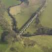
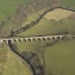
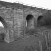
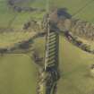
Westfield, Avon Viaduct


Railway Viaduct (19th Century)
Site Name Westfield, Avon Viaduct
Classification Railway Viaduct (19th Century)
Alternative Name(s) River Avon; Avonbridge Viaduct; Westfield Viaduct
Canmore ID 123079
Site Number NS97SW 34
NGR NS 93373 72666
NGR Description NS 9334 7268 to NS 9348 7255
Datum OSGB36 - NGR
Permalink http://canmore.org.uk/site/123079


- Council Falkirk
- Parish Muiravonside
- Former Region Central
- Former District Falkirk
- Former County Stirlingshire
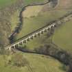
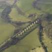
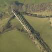
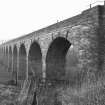
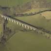
Westfield Viaduct, c.1850
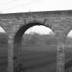
Its 12 wide, segmental arches with two narrower arches at each end bring drama to this forgotten corner of West Lothian.
Taken from "West Lothian: An Illustrated Architectural Guide", by Stuart Eydmann, Richard Jaques and Charles McKean, 2008. Published by the Rutland Press http://www.rias.org.uk

NS77SW 34 93350 72686 (NS 9334 7268 to NS 9348 7255)
Avon Viaduct: The first stone of this structure was laid on the 11th August 1854 and it is composed of 16 arches, 12 large ones of about 47ft span and two small ones at each end. It is about 660ft long and 60ft to the top of the arch from the bed of the Avon Water, which now runs through a wide but not very deep glen at this place. It is the property of the Monklands Railway Co., and was erected for their single line of railway (Blackston to Boghead Branch).
Name Book (Linlithgowshire), 1856
(Location cited as NS 934 727). Viaduct, Westfield, built c. 1850 for the Monkland Rly. A 16-span masonry viaduct with 12 main spans and a pair of smaller approach spans at each end, all semicircular. The main spans are strengthened with old rails. Now disused.
J R Hume 1976.
This viaduct formerly carried the Glasgow-Bathgate-Edinburgh line of the (former) North British Rly. over the valley of the River Avon, which here forms the boundary between the parishes of Muiravonside (Stirlingshire) and Torphichen (West Lothian).
Information from RCAHMS (RJCM), 20 November 1997.

