Accessibility

Font Size

100% 150% 200%

Background Colour

Default Contrast
Close Reset

East Langwell

Building (Post Medieval), Cairnfield (Prehistoric)

Site Name East Langwell

Classification Building (Post Medieval), Cairnfield (Prehistoric)

Canmore ID 122586

Site Number NC70NW 94

NGR NC 7210 0680

Datum OSGB36 - NGR

Permalink http://canmore.org.uk/site/122586

Ordnance Survey licence number AC0000807262. All rights reserved.
Canmore Disclaimer. © Bluesky International Limited 2025. Public Sector Viewing Terms

Toggle Aerial | View on large map

Digital Images

Cnoc Achad na h-Uaighe, East Langwell, oblique aerial view, taken from the NNW, centred on an area defined as an archaeological landscape, small cairns, hut-circles and a building. The remains of two buildings, fieldbanks and small cairns is visible in the upper right-hand corner, as well as an area with small cairns in the upper left-hand corner.
Cnoc Achad na h-Uaighe, East Langwell, oblique aerial view, taken from the NNW, centred on an area defined as an archaeological landscape, small cairns, hut-circles and a building. The remains of two buildings, fieldbanks and small cairns is visible in the upper right-hand corner, as well as an area with small cairns in the upper left-hand corner.Achnahuie, East Langwell, Cnoc Achadh na h-Uaighe, oblique aerial view, taken from the NE, showing small cairns and an area with a hut-circle, small cairns, lynchets and a possible hut in the centre of the photograph, and the remains of a building and small cairns in the upper left-hand corner.An oblique aerial view of Achnahuie,  Rogart, Sutherland, looking NE.An oblique aerial view of Cnoc Dubh, East Langwell, Rogart, Sutherland, looking NE.Cnoc Achad na h-Uaighe, East Langwell, oblique aerial view, taken from the N, centred on an area defined as an archaeological landscape, hut-circles, small cairns and a builidng. The remains of two buildings, fields banks and small cairns are visible in the top left-hand corner of the photograph.Achnahuie, East Langwell, Cnoc Achadh na h-Uaighe, oblique aerial view, taken from the ENE, showing small cairns in the centre of the photograph, and the remains of a building and small cairns in the upper left-hand corner. An area with a hut-circle, small cairns, lynchets and a possible hut is visible in the upper right-hand corner.

Administrative Areas

  • Council Highland
  • Parish Rogart
  • Former Region Highland
  • Former District Sutherland
  • Former County Sutherland

Activities

Field Visit (11 May 1995)

NC70NW 94 7210 0680

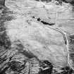
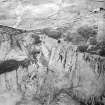
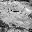
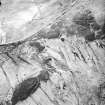
There are about thirty small cairns (ROG95 949), measuring up to 5m in diameter and 0.5m in height on the crest and SW-facing flank of the semi-improved ridge to the NNW of East Langwell.

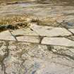
A building (ROG95 291, NC 7209 0670) is situated on a terrace at the SW fringe of the small cairns. It measures 8.3m from NE to SW by 2.6m transversely within faced-rubble footings 0.8m in thickness and 0.6m in height; there is an entrance in the SE side. The building is shown as roofed on the 2nd edition of the OS 6-inch map (Sutherland 1907, sheet xcvi) and, while the 1st edition map (Sutherland 1897, sheet xcvi) also depicts a roofed building at this location, it is aligned from NW to SE. Both buildings may have been associated with the farmstead to the SE (NC 70NW 95)

(ROG95 291, 949)

Visited by RCAHMS (DCC), 11 May 1995.

References

MyCanmore Image Contributions


Contribute an Image

MyCanmore Text Contributions