|
All Other |
MS 731/17 |
Records of the Royal Commission on the Ancient and Historical Monuments of Scotland (RCAHMS), Edinbu |
Afforestable Land Survey field database (Rogart survey, 1995). Held as attribute table in GIS and in Oracle Field/AP table. Please see DX001425 |
1995 |
Item Level |
|
|
Photographs and Off-line Digital Images |
C 46017 |
RCAHMS Aerial Photography |
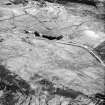
Cnoc Achad na h-Uaighe, East Langwell, oblique aerial view, taken from the N, centred on an area defined as an archaeological landscape, hut-circles, small cairns and a builidng. The remains of two buildings, fields banks and small cairns are visible in the top left-hand corner of the photograph. |
13/6/1995 |
Item Level |
|
|
Photographs and Off-line Digital Images |
C 46018 |
RCAHMS Aerial Photography |
Cnoc Achad na h-Uaighe, East Langwell, oblique aerial view, taken from the NNW, centred on an area defined as an archaeological landscape, small cairns, hut-circles and a building. The remains of two buildings, fieldbanks and small cairns is visible in the upper right-hand corner, as well as an area with small cairns in the upper left-hand corner. |
13/6/1995 |
Item Level |
|
|
Photographs and Off-line Digital Images |
C 46022 |
RCAHMS Aerial Photography |
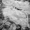
Achnahuie, East Langwell, Cnoc Achadh na h-Uaighe, oblique aerial view, taken from the ENE, showing small cairns in the centre of the photograph, and the remains of a building and small cairns in the upper left-hand corner. An area with a hut-circle, small cairns, lynchets and a possible hut is visible in the upper right-hand corner. |
13/6/1995 |
Item Level |
|
|
Photographs and Off-line Digital Images |
C 46023 |
RCAHMS Aerial Photography |
Achnahuie, East Langwell, Cnoc Achadh na h-Uaighe, oblique aerial view, taken from the NE, showing small cairns and an area with a hut-circle, small cairns, lynchets and a possible hut in the centre of the photograph, and the remains of a building and small cairns in the upper left-hand corner. |
13/6/1995 |
Item Level |
|
|
Photographs and Off-line Digital Images |
B 97917 CS |
RCAHMS Aerial Photography |
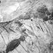
Cnoc Achad na h-Uaighe, East Langwell, oblique aerial view, taken from the NW, centred on an area defined as an archaeological landscape, the remains of a building, and an area with a hut-circle, small cairns, lynchets and a possible hut. The remains of two buildings, fieldbanks and small cairns are visible in the top half of the photograph. |
13/6/1995 |
Item Level |
|
|
Photographs and Off-line Digital Images |
B 97918 CS |
RCAHMS Aerial Photography |
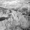
Cnoc Achad na h-Uaighe, Achnahuie, East Langwell, oblique aerial view, taken from the NW, centred on an area defined as an archaeological landscape, the remains of a building, a hut-circle, lynchets, small cairns and a possible hut. The remains of a building and small cairns is visible in the upper right-hand corner of the photograph, as is an area with hut-circles and a hut in the bottom right-hand corner. |
13/6/1995 |
Item Level |
|
|
Manuscripts |
MS 36/6 |
Records of the Royal Commission on the Ancient and Historical Monuments of Scotland (RCAHMS), Edinbu |
Field notebook of A O Curle (RCAHMS). Titled 'Sutherland no. III'. |
6/7/1909 |
Item Level |
|
 |
On-line Digital Images |
SC 1692927 |
RCAHMS Aerial Photography |
Cnoc Achad na h-Uaighe, East Langwell, oblique aerial view, taken from the N, centred on an area defined as an archaeological landscape, hut-circles, small cairns and a builidng. The remains of two buildings, fields banks and small cairns are visible in the top left-hand corner of the photograph. |
13/6/1995 |
Item Level |
|
 |
On-line Digital Images |
SC 1692928 |
RCAHMS Aerial Photography |
Cnoc Achad na h-Uaighe, East Langwell, oblique aerial view, taken from the NNW, centred on an area defined as an archaeological landscape, small cairns, hut-circles and a building. The remains of two buildings, fieldbanks and small cairns is visible in the upper right-hand corner, as well as an area with small cairns in the upper left-hand corner. |
13/6/1995 |
Item Level |
|
 |
On-line Digital Images |
SC 1692932 |
RCAHMS Aerial Photography |
Achnahuie, East Langwell, Cnoc Achadh na h-Uaighe, oblique aerial view, taken from the ENE, showing small cairns in the centre of the photograph, and the remains of a building and small cairns in the upper left-hand corner. An area with a hut-circle, small cairns, lynchets and a possible hut is visible in the upper right-hand corner. |
13/6/1995 |
Item Level |
|
 |
On-line Digital Images |
SC 1692933 |
RCAHMS Aerial Photography |
Achnahuie, East Langwell, Cnoc Achadh na h-Uaighe, oblique aerial view, taken from the NE, showing small cairns and an area with a hut-circle, small cairns, lynchets and a possible hut in the centre of the photograph, and the remains of a building and small cairns in the upper left-hand corner. |
13/6/1995 |
Item Level |
|
 |
On-line Digital Images |
SC 1906994 |
Papers of James Sloan Bone, landscape historian, Inverness, Highland, Scotland |
An oblique aerial view of Achnahuie, Rogart, Sutherland, looking NE. |
2001 |
Item Level |
|
 |
On-line Digital Images |
SC 1906995 |
Papers of James Sloan Bone, landscape historian, Inverness, Highland, Scotland |
An oblique aerial view of Cnoc Dubh, East Langwell, Rogart, Sutherland, looking NE. |
2001 |
Item Level |
|
|
Digital Files (Non-image) |
DX 001425 |
Records of the Royal Commission on the Ancient and Historical Monuments of Scotland (RCAHMS), Edinbu |
RCAHMS Structures Database - Rogart |
1995 |
Item Level |
|
|
Digital Files (Non-image) |
TM 000355 |
Records of the Royal Commission on the Ancient and Historical Monuments of Scotland (RCAHMS), Edinbu |
Zip file containing all survey linework collected during the RCAHMS Afforestable Land Survey of the Rogart area 1995. |
1995 |
Item Level |
|
|
Digital Files (Non-image) |
TM 002205 |
Records of the Royal Commission on the Ancient and Historical Monuments of Scotland (RCAHMS), Edinbu |
Zip file containing all survey linework collected during the RCAHMS Afforestable Land Survey of the Rogart area 1995. SHP and Geojson file formats with extra attribution added to the linework. |
1995 |
Item Level |
|
|
Manuscripts |
MS 36/9 |
Records of the Royal Commission on the Ancient and Historical Monuments of Scotland (RCAHMS), Edinbu |
Journal of A O Curle (RCAHMS). Sutherland I. |
15/5/1909 |
Batch Level |
|


