
Loch Beinn A' Mheadhoin, Dam


Dam (20th Century)
Site Name Loch Beinn A' Mheadhoin, Dam
Classification Dam (20th Century)
Alternative Name(s) Fasnakyle; Loch Benevean Dam; Affric/farrer/beauly Hydro-electric Scheme
Canmore ID 12169
Site Number NH22NE 5.01
NGR NH 27366 27558
NGR Description centred
Datum OSGB36 - NGR
Permalink http://canmore.org.uk/site/12169


- Council Highland
- Parish Kilmorack
- Former Region Highland
- Former District Inverness
- Former County Inverness-shire
Publication Account (1995)
The Glen Affric scheme was the first stage in the development of the Beauly River resources. The main power station at Fasnakyle on the River
Glass, 3km southwest of Cannich, opened in 1950, is built of stone as more in keeping with the landscape than concrete. It is faced with golden-yellow sandstone from near Burghead in Morayshire, and the decorative carvings near the top include an adaptation of the Pictish bull symbol so popular at Burghead. Beyond Fasnakyle is Loch Benevean with a dam across its mouth 37m high; there are car park and viewpoints here. Beyond is Loch Affric, in what is generally considered one of the most beautiful glens in Scotland. Care was taken not to alter the level of water in this loch.
Extra water is brought to Loch Benevean by a tunnel, 5.5km long, through the hills from Loch Mullardoch; to get to the latter by road requires a return to Cannich. The dam on Loch Mullardoch (NH 222313) is much larger and higher than that at Benevean, being 727m long and 48m high. Further north in another section of the scheme there are dams in Glen Strathfarrar. Here there is a dam at the end of Loch Beannacharan (NH 325393), and an interesting dam on Loch Monar (NH 203393) built in a curve. Few examples of such arch dams are found in Britain because the shape of the valleys are generally unsuitable. The Loch Monar dam is some 22km up a single track road: this is a gated private road passing thtough a nature reserve, open to walkers and bicyclists, but with limited access for cars in summer (tel. gatekeeper, Struy 260).
In the gorge of the Beauly River there are two smaller dams, both incorporating a power station, at Aigas (NH 474436) and Kilmorack (NH 494442). Both these dams and that at Loch Beannacharan incorporate Borland fish passes, which allow salmon to pass up and down stream: these are not conventional fish ladders, but work more like locks on a canal. The fish lift at Aigas dam is open to the public. All the power from the Glen Affric/Farrer/Beauly stations is fed into the Highland Grid.
Information from ‘Exploring Scotland’s Heritage: The Highlands’, (1995).
Field Visit (2010)
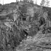
This dam is located 13 km below the natural outlet of the loch, and thus raised its level to provide flow regulation and a degree of storage for Fasnakyle power station (see separate listing). The reservoir is supplemented by water from Mullardoch dam at the top of Glen Strathfarrar (see separate item) which passes though an underground power station before entering Loch Beinn a Mhedoin upstream of Bennevean dam. The water level in the loch is closely controlled to ensure that the level remains virtually constant, ensuring that the scenic amenity of the upper Glen Affric is affected as little as possible. The outlet to Fasnakyle power station is controlled by the intake gatehouse located adjacent to the upstream face of the dam. The dam is located at a narrow section of the former river bed, specifically designed to be hard to see because of the concerns over visual amenity during the development of the scheme. The dam is of relatively standard type, with a fixed spillway and central buttress sweeping up to form part of the control gate tower. The large gatehouse adjacent to the upstream face of the dam is of relatively standard design with a cantilevered section supported by round concrete piers above the tunnel intake and trash screen. PL Payne, 1988, 5; E Wood, 2002, 38; J Miller, 2002.
Note (25 October 2023)
The Affric/ Beauly scheme
The work was begun on the construction of Mullardoch Dam in 1947. This is of the mass gravity type and is 2385 feet in length by 160 feet in height, impounding 7.5 million cubic feet of water. A tunnel was excavated from Loch Mullardoch to Loch Benevan, and another from the latter loch to Fasnakyle, the main power station on the River Affric, both tunnels being over three miles in length. The Fasnakyle tunnel splits into three steel-lined tunnels near the power station, each supplying a 22,000kW vertical Francis turbo-alternator.
The second stage of the scheme involved the Rivers Farrar and Beauly. Water is impounded in Loch Monar by the Monar Dam, supplying the Deanie power station at the west end of Loch Bennacharan which is dammed at the east end to feed Culligran power station, whose outflow to the River Farrar then flows into the River Glass. These power stations generate 38MW and 24MW respectively. The River Glass flows into the River Beauly which has dams and power stations at Aigas and Kilmorack, each a 20MW run of river station. These dams are provided with flood control, Borland fish passes and compensation water facilities with or without generation. The scheme was completed in 1963.
Information from NRHE, catalogue item number WP007424 compiled by George Walker, 2005.

