
Pricing Change
New pricing for orders of material from this site will come into place shortly. Charges for supply of digital images, digitisation on demand, prints and licensing will be altered.
Mallaig, General


General View (Period Unassigned), Head Dyke (Post Medieval), Township (Period Unassigned)
Site Name Mallaig, General
Classification General View (Period Unassigned), Head Dyke (Post Medieval), Township (Period Unassigned)
Canmore ID 118331
Site Number NM69NE 1
NGR NM 676 969
NGR Description Centred NH 676 969
Datum OSGB36 - NGR
Permalink http://canmore.org.uk/site/118331


- Council Highland
- Parish Glenelg (Lochaber)
- Former Region Highland
- Former District Lochaber
- Former County Inverness-shire
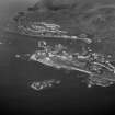
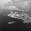
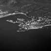
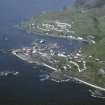
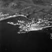
Mallaig (Malaig) In 1900, Mallaig was a humble settlement with a scattering of thatched houses. A stone pier and salt store had been built by Lord Lovat in 1846/7 as part of his plans to develop a fishing port, but Mallaig's potential to become a thriving centre with ready access to the Minch and its islands was really only set in motion with the arrival of the West Highland Railway. Gulls still wheel around fishing boats in the harbour (whose principal commodity today is prawns), but the focus of the place has shifted now from fish loading and kippering to ferry traffic, and the service of travellers coming and going by road, rail and sea. This seasonal transience is nothing new to Mallaig, for in the old days the population swelled and ebbed depending on the herring fishing - few actually lived in Mallaig, so little was invested here. Today, the village spills out from a short main street of ice creamcoloured houses to an amphitheatre of later 20th century housing, which stretches round the bay to
Mallaig Bheag, the original crofting settlement and landing place of Bonnie Prince Charlie after his escape from Skye in July 1746.
Taken from "Western Seaboard: An Illustrated Architectural Guide", by Mary Miers, 2008. Published by the Rutland Press http://www.rias.org.uk

NM69NE 1 centred 676 969
A township, comprising eleven roofed buildings, one unroofed building, one enclosure and a length of head-dyke is depicted on the 1st edition of the OS 6-inch map (Inverness-shire 1876, sheet cvi). The town of Mallaig now occupies this location.
Information from RCAHMS (AKK) 14 August 1996.

