
Pricing Change
New pricing for orders of material from this site will come into place shortly. Charges for supply of digital images, digitisation on demand, prints and licensing will be altered.
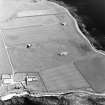
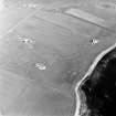
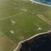
Sanday, Thrave Steading


Farmstead (Period Unassigned)
Site Name Sanday, Thrave Steading
Classification Farmstead (Period Unassigned)
Alternative Name(s) Thrave Steading
Canmore ID 116653
Site Number HY74SE 27
NGR HY 76471 43863
NGR Description Centred HY 76471 43863
Datum OSGB36 - NGR
Permalink http://canmore.org.uk/site/116653


- Council Orkney Islands
- Parish Lady
- Former Region Orkney Islands Area
- Former District Orkney
- Former County Orkney
HY74SE 27 76471 43863.
This farmstead comprises two single-storeyed ranges at right angles. It includes byres and two dwellings.
Information from RCAHMS (SS) 19 January 2006.
Field Visit (10 April 2008 - 14 April 2008)
HY 7650 4384 Work was undertaken on 10–14 April 2008 to ascertain the presence and location of the possible remains of a treb dyke (a type of prehistoric boundary). The possible remains of a treb dyke (HY74SE 19), or perhaps a small occupation site, were noted in the ploughed field W of the plot and at Thrave by a small mound in the N part of the plot, N of the steading buildings.
The Thrave steading (HY74SE 27) consists of two ranges, set at right-angles to each other, with associated walled vegetable plots or animal pens. The steading is of traditional vernacular construction and design, with flagstone walls, floors and roofs, a domestic dwelling in each range, a threshing barn and byres and so on. The steading was recorded by the RCAHMS during the Scottish Farm Buildings Survey.
Archive: Orkney SMR (intended)
Funder: Ms Paula Batey
Paul Sharman (ORCA), 2008

