
Following the launch of trove.scot in February 2025 we are now planning the retiral of some of our webservices. Canmore will be switched off on 24th June 2025. Information about the closure can be found on the HES website: Retiral of HES web services | Historic Environment Scotland
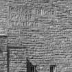
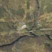
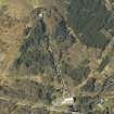
Grudie Bridge Power Station


Hydroelectric Power Station (Modern)
Site Name Grudie Bridge Power Station
Classification Hydroelectric Power Station (Modern)
Alternative Name(s) Conon Valley Hydroelectric Power Scheme
Canmore ID 106959
Site Number NH36SW 4
NGR NH 31010 62368
Datum OSGB36 - NGR
Permalink http://canmore.org.uk/site/106959


- Council Highland
- Parish Contin
- Former Region Highland
- Former District Ross And Cromarty
- Former County Ross And Cromarty
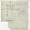
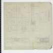
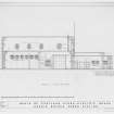
Field Visit (2010)
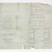
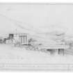
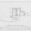
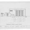
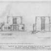
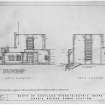
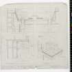
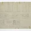
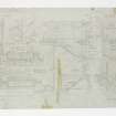
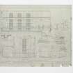
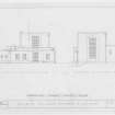
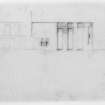
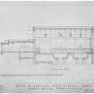
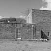
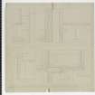
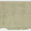
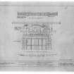
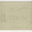
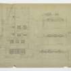
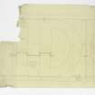
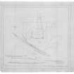
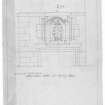
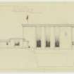
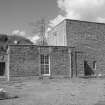
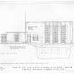
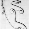
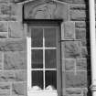
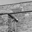
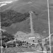
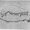
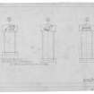
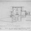
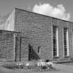
Grudie Bridge power station was the earliest to be developed on the Conon scheme with water provided via a tunnel from Fannich Dam (see separate item). The turbine hall has two turbines with a transformer station to the rear providing the connection to the grid. The station was designed as the control for this section of the scheme and has offices and workshops to accommodate this. The turbine hall oversails the tailrace which discharges into Loch Luichart before being used again for generation at Luichart station. There is a degree of later alteration to the interior of the station for continued use and there is upgrading to turbines for compliance with ROC. Later alterations also include the installation of an oil coolant system. The design is broadly functional with squared red sandstone rubble and large rectangular windows characteristic of the modernist designs seen across the sector. The building also makes reference to its context with carved panels depicting a variety of mythical Celtic beasts. this is a relatively small example of a barrage which is still operating as designed to control flow of the river and divert water through Achanalt power station. There has been a degree of alteration to the control gates as required to allow for continued use. P L Payne, 1988, 5; E Wood, 2002, 38; J Miller, 2002.
Note (25 October 2023)
The Conon scheme
This project involves three separate stages: the Fannich scheme, the Glascarnoch-Luichart-Torr Achilty scheme and the Orrin scheme. The first of these involved tunnels and aqueducts to increase the flow into Loch Fannich, and a tunnel from the bed of Loch Fannich to the Grudie Bridge power station at the west end of Loch Luichart. This involved a severe problem at the Loch Fannich end. Work began in 1946 and a dam was built later, completing the section in 1951.
Work began on the second stage in 1951., producing two artificial lochs Vaich and Glascarnoch by damming the respective rivers, using the earth and rockfill method. Tunnels were excavated between these lochs and from Loch Glascarnoch to Mossford power station on Loch Luichart. A dam at the east end of Loch Achanalt allows loch to supply the Achsanalt power station near Grudie Bridge. Two artificial lochs Meig and Achonachie were produced by dams on the rivers Meig and Conon to supply power stations at Luichart and Torr Achilty respectively. Work on this section was completed in 1957.
The Orrin scheme was started in 1955 and involved the building of a mass gravity dam 1000 feet long and an earth embankment also 1000 feet in length to seal off a branch valley, thus forming the Orrin Reservoir. The outflow is through a concrete -lined tunnel to a steel pipeline supplying the Orrin power station at Loch Achonachie. Four Borland fish lifts had been installed at Luichart, Meig, Achanalt and Torr Achilty. The scheme was completed in 1961, the six power stations producing an output well over 100,000 kW.
Information from NRHE catalogue record WP007424, compiled by George Walker, 2005.

