
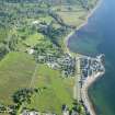
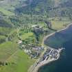
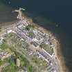
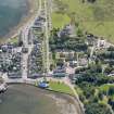
Inveraray Pier


Harbour (18th Century), Pier (18th Century)
Site Name Inveraray Pier
Classification Harbour (18th Century), Pier (18th Century)
Alternative Name(s) Loch Fyne
Canmore ID 106713
Site Number NN00NE 27
NGR NN 09770 08569
Datum OSGB36 - NGR
Permalink http://canmore.org.uk/site/106713


- Council Argyll And Bute
- Parish Inveraray
- Former Region Strathclyde
- Former District Argyll And Bute
- Former County Argyll
Field Visit (May 1989)
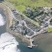
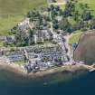
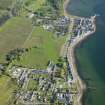
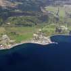
This stone-built pier extends NE from the NE angle of the promontory on which the New Town is built, at the E end of Front Street. It was proposed in 1754 as a replacement for the unsatisfactory harbour in the mouth of the River Aray, and some stone was quarried a year later, but the burgh authorities had difficulty in collecting funds and work began, to a design by John Adam, only in 1759. This structure, built by James Potter, was heightened in 1765, and was only about 30m in length, terminating well above low watermark, while in 1771 measures were required to prevent silting to the W. Its inadequate state led the 5th Duke of Argyll to obtain estimates for an extension in 1795, and to commission a design by Alexander Nasmyth for an elaborate lighthouse tower (see No. 185). Plans to restore the quay and double its length at an estimated cost of £865 were finally commissioned by the Burgh from William Johns in 1805, and carried out under the supervision of J Gillespie (Graham), who recommended the use of iron straps. It was further extended below low-water mark in 1836 by an oblique N pierhead with an outer 'slip to suit every state of the tide', whose cost was variously estimated at £1200 or £1435, most of which was paid by the Fishery Board. A T-plan timber extension for steamer-traffic was added in 1877, and modified during the present century (en.1).
The masonry structure measures about 8m in width by70m in length to the return of the pierhead, and is built of well-squared and coursed blocks, of granite in the outer half. The pier head measures 20m from N to S by 10m, which includes on the E face a slipway with two pawls recessed into the wall, and a small stairway. Two other flights of steps are built into the W face of the pier, at the E and wends (en.2*).
RCAHMS 1992, visited May 1989

