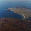
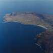
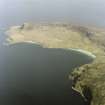
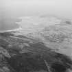
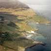
Accessibility

Font Size

100% 150% 200%

Background Colour

Default Contrast
Close Reset

Eigg, General

General View (Period Unassigned)

Site Name Eigg, General

Classification General View (Period Unassigned)

Canmore ID 106170

Site Number NM48NE 47

NGR NM 4600 8600

NGR Description Centred on NM 4600 8600

Datum OSGB36 - NGR

Permalink http://canmore.org.uk/site/106170

Ordnance Survey licence number AC0000807262. All rights reserved.
Canmore Disclaimer. © Bluesky International Limited 2025. Public Sector Viewing Terms

Toggle Aerial | View on large map

Digital Images

General oblique aerial view of the Islands of Muck, Eigg, Rum and Skye, taken from the SSE.
General oblique aerial view of the Islands of Muck, Eigg, Rum and Skye, taken from the SSE.General oblique aerial view of the Island of Muck and Eilean nan Each with Eigg in the background, taken from the SW.General oblique aerial view of the N end of Eigg, including Bay of Laig and Cleadale, taken from the S.Oblique aerial view of the N end of Eigg, taken from the NE.Eigg, general view.  Oblique aerial photograph taken facing west.  This image has been produced from a damaged print.Oblique aerial view with Eigg and Rum in the distance.General oblique aerial view of the west side of Eigg with the fort in the foreground and the Sgurr fort beyond, taken from the NW.General oblique aerial view of the west side of Eigg with the fort in the foreground and the Sgurr fort beyond, taken from the NNW.General oblique aerial view of the west side of Eigg with the fort in the foreground and the Sgurr fort beyond, taken from the NW.General oblique aerial view of Eigg, Muck and Rum, taken from the SE.Copy of a historic photographic view of a boy digging with 'caschrom', entitled 'ploughing'.  From the Banff Album.General oblique aerial view of Eigg centred on Bay of Laig, looking SSE.General oblique aerial view of the N end of Eigg, taken from the S.General oblique aerial view of the N end of Eigg centred on Bay of Laig and Cleadale, taken from the S.Eigg. View of Galmisdale and Eilean Chathastail from An Sgurr.General oblique aerial view of the west side of Eigg with the fort in the foreground and the Sgurr fort beyond, taken from the NNW.Detail of shieling hut, creepGeneral oblique aerial view of Cleadale and the north end of Eigg, taken from the S.General oblique aerial view looking across Laig Bay, with the fort in the foreground, towards Cleadale and the north side of Eigg, taken from the W.Violet Banks Photograph Album - The Small Isles - Page 34 - View of Eigg from Isle of MuckGeneral oblique aerial view of the Island of Eigg, taken from the NE.General oblique aerial view of the N end of Eigg, including Bay of Laig and Cleadale, taken from the SSW.Distant view of islands.
Titled: 'Islands of Eigg & Muck from Keppoch 24604 J.V.'
PHOTOGRAPH ALBUM NO.33: COURTAULD ALBUM.General oblique aerial view of Eigg and Rum, looking NW.Oblique aerial view of the Isle of Eigg, Small Isles, from SW.Oblique aerial view of Ardnamurchan lighthouse with Eigg beyond, looking N.General oblique aerial view of Eigg and Rum, looking NW.General oblique aerial view of Blabheinn with the Cullin Hills, Loch Scavaig, Soay, Eigg, Rum and Canna beyond, looking SSW.Map of Eigg showing locations mentioned in chapter. HES publication map, 400dpi copy of GV006099UnidentifiedGeneral oblique aerial view centred on the island of Eigg, taken from the SW.A distant oblique aerial view of Eigg and Rum, looking N.General oblique aerial view looking over the fort of An Sgurr towards the N end of Eigg, including Bay of Laig and Cleadale, taken from the SSW.General oblique aerial view looking across Laig Bay towards Cleadale and the north side of Eigg, taken from the SW.General oblique aerial view centred on the island of Eigg, taken from the SW.General oblique aerial view looking across Laig Bay, with the fort in the foreground, towards Cleadale and the north side of Eigg, taken from the WNW.General oblique aerial view of Eigg, Muck and Rum, taken from the SE.Violet Banks Photograph Album - The Small Isles - Page 35 - Views from Isle of MuckOblique aerial view of the Isle of Eigg, Small Isles, from SW.General oblique aerial view looking across Laig Bay, with the fort in the foreground, towards Cleadale and the north side of Eigg, taken from the WNW.General oblique aerial view with Sorobaidh Bay in the foreground, Hynish Bay beyond and Rum and Eigg in the far distance, looking to the NE.General oblique aerial view of Eigg, looking S.General oblique aerial view of Eigg with Muck beyond, looking S.General oblique aerial view of the Point of Ardnamurchan looking out towards the Islands of Rum, Eigg, Muck and Skye, taken from the S.General oblique aerial view of the Islands of Muck and Eigg, taken from the SSW.General oblique aerial view of Cleadale and Bay of Laig, taken from the NE.Oblique aerial view of Sanna and Portuairk with Eigg, Muck and Rum beyond, looking N.Ink tracing of William Bald's map (1806) of Eigg by Susanna Wade MartinsShieling hut with low creepGeneral oblique aerial view centred on the island of Eigg, taken from the SW.General oblique aerial view of Cleadale and the north end of Eigg, taken from the S.General oblique aerial view of Eigg, Muck and Rum, taken from the SE.General oblique aerial view looking towards the Keppoch Peninsula and the distant Islands of Rum and Eigg centred on Back of Keppoch farmstead, taken from the E.General oblique aerial view of the Islands of Muck and Eigg, taken from the SW.General oblique aerial view of the N end of Eigg, including Bay of Laig and Cleadale, taken from the SSW.General oblique aerial view of the N end of Eigg centred on Cleadale, taken from the W.General oblique aerial view of Eigg, Rum and Canna with Gleann Meadhonach, Sleat, in the foreground, looking WSW.General oblique aerial view of Blabheinn with the Cullin Hills, Loch Scavaig, Soay, Rum and Canna beyond, looking SSW.General oblique aerial view of the southwest side of Eigg with the remains of An Sgurr fort in the distance, taken from the NNW.General oblique aerial view centred on the island of Eigg, taken from the SW.General oblique aerial view of the southwest side of Eigg with the remains of An Sgurr fort in the distance, taken from the NW.Oblique aerial view of Galmisdale and Kildonan, Isle of Eigg, looking NE. Oblique aerial view of the Sgurr of Eigg (An Sgurr), Isle of Eigg, looking NW.View of man and dog, probably at Eigg. 
Titled: 'Donald McLean and Prince'

View of anglers in boat
Titled: 'Look when we caught fish, Eigg'

General oblique aerial view of Cleadale and Bay of Laig, taken from the NNE.Oblique aerial view of Ardnamurchan lighthouse with Eigg, Muck and Rum beyond, looking N.General oblique aerial view of Muck, Eigg and Rum, looking WNW.General oblique aerial view of Eigg, Rum and Canna with Gleann Meadhonach, Sleat, in the foreground, looking WSW.Unidentified, rock shelterCopy of a historic photographic view of a boy digging with 'caschrom', entitled 'ploughing'.  From the Banff Album.General oblique aerial view of the southwest side of Eigg with the remains of An Sgurr fort in the distance, taken from the NNW.

Administrative Areas

  • Council Highland
  • Parish Small Isles
  • Former Region Highland
  • Former District Lochaber
  • Former County Inverness-shire

Recording Your Heritage Online

EIGG

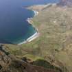
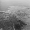
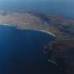
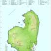
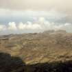
If the story of the Gàidhealtachd can be told through the microcosm of individual islands, none succeeds more emotively than Eigg, visible from afar as a tilting, sharp-spined flank with guiding fin. Buildings and landscape chronicle turbulent chapters of Hebridean history, from settlement by Mesolithic hunter-fishermen and the vicissitudes of inter-clan rivalry, kelp harvesting and over-population, to the coming of sheep, wealthy sportsmen and 'white settlers'. Following the earliest occupants, Neolithic farmers and then Iron Age Celts colonised the island's fecund slopes, their legacy curious burial mounds and a series of coastal duns and stone wheelhouses. In the early 7th century, St. Donnan arrived by coracle with some zealous disciples and founded a monastery here. Norse domination has yielded a number of fabulous artefacts, of particular note an encrusted bronze sword hilt and a longship's stern (now in the National Museum of Scotland). Eigg's strategic location on the sea highway that was the nerve system of Garmoran made the island an important part of the 14 th century, inheritance of Ranald MacRuari, progenitor of Clanranald. A royal charter was granted, but feuds between the Clanranalds and their rivals persisted, culminating in the infamous suffocation of the island's population in a cave (Uamh Fhraing - Cave of St. Francis) by the Macleods of Harris and Skye in the 16th century. Eigg remained in Clanranald ownership until 1827/8 when, already plagued by evictions and emigration, it was sold to alleviate debts. Dr Hugh Macpherson, sub-principal of Kings College, Aberdeen, became the new owner, and during his and his descendants' absentee proprietorship the island suffered greatly from famine and widespread clearances. With its sale in 1896 to Robert Lawrence Thomson MacEwen (alias Robert Thomson, Far Eastern Times correspondent turned international arms dealer, who also owned Muck and Strathaird), Eigg saw the coming of the first of a new breed of island owner: the Edwardian magnate. Thomson carried out some improvements but sold in 1916 to the London ship owner, Sir William Petersen. Around 1925 another shipping tycoon and government minister, the improving and modernising sportsman Sir Walter Runciman, became laird and saw Eigg through a period of relative prosperity, during which the island enjoyed a harmony denied it in subsequent decades. In 1997, it was the subject of a much-publicised community buy-out, which established an incentive for other remote communities across the Highlands and Islands.

Taken from "Western Seaboard: An Illustrated Architectural Guide", by Mary Miers, 2008. Published by the Rutland Press http://www.rias.org.uk

Activities

Aerial Photography (2 September 1994)

Aerial Photography (3 May 2007)

References

MyCanmore Image Contributions


Contribute an Image

MyCanmore Text Contributions