Accessibility

Font Size

100% 150% 200%

Background Colour

Default Contrast
Close Reset

Harris, Rodel Hotel

Hotel (20th Century), Hunting Lodge (19th Century), Lairds House (18th Century)

Site Name Harris, Rodel Hotel

Classification Hotel (20th Century), Hunting Lodge (19th Century), Lairds House (18th Century)

Canmore ID 104485

Site Number NG08SW 11
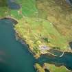
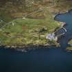
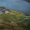
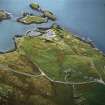
NGR NG 04769 82906

Datum OSGB36 - NGR

Permalink http://canmore.org.uk/site/104485

Ordnance Survey licence number AC0000807262. All rights reserved.
Canmore Disclaimer. © Bluesky International Limited 2025. Public Sector Viewing Terms

Toggle Aerial | View on large map

Digital Images

View of Rodel Hotel, Harris, from west-north-west.
View of Rodel Hotel, Harris, from west-north-west.View from SE.View from S of main block.View of entrance to public bar.Oblique aerial view centred on the hotel and remains of the military camp with the church and burial ground adjacent, taken from the S.View from NE.Oblique aerial view.Oblique aerial view centred on the hotel and remains of the military camp with the church and burial ground adjacent, taken from the WSW.Oblique aerial view centred on the church and burial ground and the remains of the military camp with the hotel and remains of the boat nausts adjacent, taken from the W.View from SE.Rodel Hotel, view from NE.View from NE of corrugated N additions.View from SW
Digital image of D 2257 CNGeneral view of Rodel Hotel, Harris, from south-west.Oblique aerial view.Oblique aerial view centred on the church and burial ground with the hotel and remains of the military camp adjacent, taken from the NE.Oblique aerial view centred on the church and burial ground with the hotel and remains of the military camp adjacent, taken from the NNE.View of gate piers looking through gate from SW.Distant view across harbour from SEView from NE.Rodel Hotel. General view from SE.Rodel Hotel. General view from SW.
Digital image of IN/1422Rodel Hotel, view from NE. Digital image of B 76251 CNView of west building at Rodel Hotel, Harris, from south-south-east.View of Rodel Hotel, Harris, from west.View from SE.Rodel Hotel, view from NE.View of gate piers looking through gate from SW.Interior.
Public bar, billiard room, view of fireplace.Oblique aerial view centred on the hotel and remains of the military camp with the church and burial ground adjacent, taken from the SSE.Oblique aerial view.Rodel Hotel. View from S.View from SE.Interior.
View from NE of billiard room in public bar.Distant view across harbour from SE
Digital image of D 2261 CNOblique aerial view centred on the church and burial ground and the remains of the military camp with the hotel and remains of the boat nausts adjacent, taken from the NE.View of Rodel Hotel, Harris, looking along south wall of harbour, from south-east.View od Rodel Hotel, Harris, from west.View from SWDistant view across harbour from SEView of main block from W.Oblique aerial view centred on the church and burial ground and the remains of the military camp with the hotel and remains of the boat nausts adjacent, taken from the ENE.View from NE.Distant view from EView of Rodel Hotel, Harris, from south-west.View of Rodel Hotel, Harris, from west.View from SE.View from N.Rodel Hotel. General view from SE.Oblique aerial view.Oblique aerial view.Oblique aerial view.General viewOblique aerial view centred on the church and burial ground with the hotel and remains of the military camp adjacent, taken from the NWOblique aerial view centred on the hotel and remains of the military camp with the church and burial ground adjacent, taken from the S.Oblique aerial view centred on the church and burial ground and the remains of the military camp with the hotel and remains of the boat nausts adjacent, taken from the E.Oblique aerial view centred on the church and burial ground and the remains of the military camp with the hotel and remains of the boat nausts adjacent, taken from the NE.View from SE.View from S of main block.Distant view from EView of Rodel Hotel, Harris, looking along south wall of harbour, from south-east.View of Rodel Hotel, Harris, from south-south-west.General view of Rodel Hotel, Harris, from west-north-west.Rodel Hotel. View from S.View from SE.View from W of ruinous E extension.View from SW of public bar and N corrugated additions.Distant view from ERodel Hotel. Detail of armorial panel on entrance gateway.Oblique aerial view.Oblique aerial view.General viewView from SE.View of entrance to public bar.Interior.
Public bar, billiard room, view of fireplace.
Digital image of B 76264 CNView from NE.View from SW of main block and public bar.Oblique aerial view.Violet Banks Photograph Album - Isle of Harris - Page 4 - RodelDetail of corrugated E wing.View from N.View from W of ruinous E extension.View from S of main block.View from SW of main block and public bar.View from SW of public bar and N corrugated additions.Interior.
Public bar, billiard room, view of fireplace.Photographic copy of engraving of Rodel Harbour.
Digital image of C 33455 CNOblique aerial view centred on the church and burial ground and the remains of the military camp with the hotel and remains of the boat nausts adjacent, taken from the E.Detail of corrugated E wing.View from NE of corrugated N additions.Interior.
View from NE of billiard room in public bar.Oblique aerial view centred on the hotel and remains of the military camp with the church and burial ground adjacent, taken from the WSW.Oblique aerial view.Oblique aerial view of Rodel, Harris, showing the harbour and St Clement's ChurchOblique aerial view centred on the hotel and remains of the military camp with the church and burial ground adjacent, taken from the SSE.Aerial view of Rodel, Isle of Harris, looking N.View from SWView of main block from W.Rodel Hotel. Detail of armorial panel on entrance gateway.

Administrative Areas

  • Council Western Isles
  • Parish Harris
  • Former Region Western Isles Islands Area
  • Former District Western Isles
  • Former County Inverness-shire

Recording Your Heritage Online

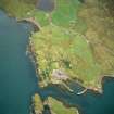
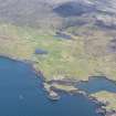
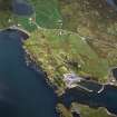
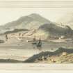
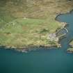
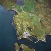
Rodel Hotel, c.1785 Unusually tall laird's house standing gable endon to the dock, lower 19th-century extension at right angles. Scene of the dramatic climax of the Balranald Elopement of 1850 (see p.371); the island's most historic house has functioned as an inn, tacksman/factor's residence, shooting lodge and hotel (for more on its history, see p.371). Now 'restored' (2001), after decades of dereliction, it is back in operation as a hotel, albeit with great loss to its original character - a blandly anonymous modern interior behind newly harled walls of grey cement.

Taken from "Western Seaboard: An Illustrated Architectural Guide", by Mary Miers, 2008. Published by the Rutland Press http://www.rias.org.uk

Activities

Field Walking (26 June 2018 - 9 July 2018)

NG 04875 82846 A programme of archaeological work

was undertaken, 26 June – 9 July 2018, in advance of

redevelopment of Rodel House, which is a category B listed

building built in the 1780s. The DBA extended 150m from

the house. A photographic and written record was produced

of the house, and a walkover survey covered the area of the

foreshore to the S of the house and the walled garden.

Archive: NRHE (intended)

Funder: John Renshaw Architects

Anthony Taylor – Headland Archaeology

(Source: DES Volume 19)

References

MyCanmore Image Contributions


Contribute an Image

MyCanmore Text Contributions