
Following the launch of trove.scot in February 2025 we are now planning the retiral of some of our webservices. Canmore will be switched off on 24th June 2025. Information about the closure can be found on the HES website: Retiral of HES web services | Historic Environment Scotland
Pabbay, Baile-lingay


Farmstead (Post Medieval), Head Dyke (Post Medieval), Kiln Barn(S) (Post Medieval), Township (Post Medieval)
Site Name Pabbay, Baile-lingay
Classification Farmstead (Post Medieval), Head Dyke (Post Medieval), Kiln Barn(S) (Post Medieval), Township (Post Medieval)
Alternative Name(s) Baile Lingaidh
Canmore ID 10384
Site Number NF88NE 5
NGR NF 8939 8750
NGR Description Centred on NF 8939 8750
Datum OSGB36 - NGR
Permalink http://canmore.org.uk/site/10384


- Council Western Isles
- Parish Harris
- Former Region Western Isles Islands Area
- Former District Western Isles
- Former County Inverness-shire
Field Visit (29 June 1965)
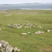
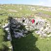
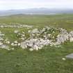
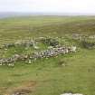
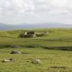
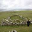
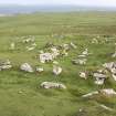
This depopulated village is entred at NF 892 874. It comprises the remains of 44 buildings, 4 of which contain corn-drying kilns; 16 enclosures, some attached to the buildings; and several old field walls in association with an extensive area of lazy-bed cultivation. The buildings are of 'black-house' type with rounded corners, and vary in size from 13.2 x 4.5m to 5.7 x 3.7m internally, with walls 1.5m wide and extant to a maximum height of 1.6m in places. The buildings in the area 889 871, appear to be the oldest, as only grass-covered footings remain.
Visited by OS (R B) 29 June 1965
Desk Based Assessment (25 May 1965)
NF88NE 5 centred on 8939 8750
(NF 894 874) Baile-Lingay: 'Lingay-town' - is a hamlet which was deserted between 1850 and 1877.
Information from OS (ES) 25 June 1965
Name Book 1877.
Note (20 March 1997)
A township and a farmstead are depicted on the 1st edition of the OS 6-inch map (Inverness-shire, Island of Harris 1881, sheet xxi). The township comprises twenty-four unroofed buildings, three of which are L-shaped, three enclosures and a head-dyke. The farmstead (NF 900 885) comprises two unroofed buildings, one of which is L-shaped and the other is attached to the head-dyke.
Thirty-four unroofed buildings, nine enclosures and a head-dyke are shown on the current edition of the OS 1:10000 map (1971).
Information from RCAHMS (SAH) 20 March 1997
Field Visit (26 June 2012)
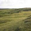
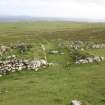
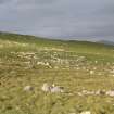
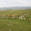
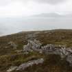
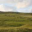
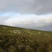
The ruins of this township are dispersed over a very large area of the grass-grown S flank of Beinn A’Charnain. The township, which straddles the Lingay Burn, measures some 600m from N to S by 520m transversely and lies within a landscape bearing evidence of both plough and hand cultivation in the form of rigs, lazy-beds and small vegetable plots.
There are three main groupings of buildings, an arrangement that is likely to reflect differences in their respective dates of establishment and occupation. There is a cluster on steep ground at the N end of the township; a linear arrangement about 175m to the SE (both to the NE of the burn), and a loose cluster of four other buildings (including NF88NE 5.2, 5.3 and 5.4) to the SW of the burn. In addition, one isolated building (NF88NE 5.1) stands 180m W of the N cluster. In most cases the buildings are rectangular thick-walled blackhouses, often with attached yards, though some of them are probably ancillary buildings. There are also kiln-barns.
The northerly group (NF 8937 8784) comprises at least 13 rectangular buildings and two enclosures in a nucleated arrangement. The buildings have generally been built parallel to the natural, SE-facing, slope and some have particularly thick walls that incorporate large boulders in their construction. The majority have their entrances set towards the SW end of their SE sides, and many can be seen to overlie earlier structures of similar form.
The linear settlement (centred NF 8939 8875), which comprises at least 19 rectangular buildings, including two kiln barns, and six enclosures, stands on the sand-covered lower slopes of the hill. These buildings are well preserved, many standing to wall-head height, and it seems likely that this group, which was occupied until the 1840s, is of later date than that the northern cluster. One of the buildings (at NF 89384 87576) has a mid-gable in which there is a fireplace.
The group to the SW of the burn is described elsewhere (see NF88NE 5.2, 5.3 and 5.4) as is the isolated building a little further to the N (see NF88NE 5.1).
Baile-lingay was cleared in the 1840s so that the associated lands could be turned over to sheep (Lawson 1994), with the inhabitants moving to other parts of the Hebrides and to Cape Breton in Canada. It is one of the three abandoned townships that were described and mapped by the Ordnance Survey in 1878 (Inverness (Hebrides) 1881, Sheet XXI; Name Book No.5).
Visited by RCAHMS (GFG) 26 June 2012

