RCAHMS Special Survey, Pabbay (Harris)


Date 25 June 2011 - 28 June 2011
Event ID 932366
Category Project
Type Project
Permalink http://canmore.org.uk/event/932366
An archaeological walk-over survey of the island of Pabbay (Harris) was undertaken by G F Geddes (RCAHMS) in order to provide comparative material for the publication of the survey of St Kilda (Gannon and Geddes 2015). The survey included a re-assessment of 9 known archaeological sites, as well as the discovery of 31 previously unrecorded sites, some of which comprise numerous individual structures. Measured survey was limited to a plane-table survey of the church, chapel and graveyard at 1:100, while 87 digital images were captured. Desk-based research included a study of vertical aerial photography, historic maps and secondary sources.
The survey noted the presence of additional prehistoric monuments, as well as a broad range of medieval and post medieval structures, including tacksmans’ houses, kiln-barns, storage pits and shieling huts. Field systems are extensive and include large areas of lazy-bedding and crofts. Some of the buildings and crofts are certainly examples of agricultural improvements that were attempted before the transformation of the island into a sheep farm in the middle of the 19th century.
Information from RCAHMS (GFG), 2018.

| Event | Type | Subtype | Notes | Date |
|---|---|---|---|---|
| 932163 | RECORDING | FIELD VISIT | This marker stone is set into the top of a crude plinth in moorland that was formerly cultivated ground. The stone is a squat pillar measuring 0.2m square at the base and rising to a height of only 0.5m. The plinth which measures about 1.2m square and about 0.3m in height, comprises only a few large boulders. [...] | 27 July 2011 |
| 932364 | RECORDING | FIELD VISIT | Seana Chaisteal (Old Castle) occupies a prominent position on a rocky knoll at the end of a broad ridge running down and SE from Beinn Narnain. It overlooks sandy beaches to the E and S and large areas of formerly cultivable land to the NE and SW, much of which was inundated by sand in the late 17th century (Lawson 1994, 16). The largely grass-grown remains include what are probably a later prehistoric dun or broch, two medieval buildings, two enclosures, and a later cairn. [...] | 27 July 2011 |
| 932296 | RECORDING | FIELD VISIT | This enclosure, which may have a small annex attached to its SW side, measures 41m square within a grass-grown bank at least 3m in thickness. The interior has been cultivated and the ridges, which are orientated NW and SE and measure about 5.8m between narrow furrows, extend over the enclosure bank on the SE. The enclosure is comparable to others recorded on the island of Killegray in 1980 (see NF98SE 8). [...] | 25 July 2011 |

SC 1242107
Site plan, Church, Teampull Mhoire & Teampull Beag, Pabbay.
Records of the Royal Commission on the Ancient and Historical Monuments of Scotland (RCAHMS), Edinbu
8/8/2011
© Crown Copyright: HES

DP 137890
View of interior from the SE.
RCAHMS Field Survey Digital Photography
27/6/2011
© Crown Copyright: HES

DP 137898
Working shot taken during the plane table survey (MIss KM Geddes in shot).
RCAHMS Field Survey Digital Photography
27/6/2011
© Crown Copyright: HES

DP 138219
South Lingay. View of building at NF 89425 87623, from the N,
RCAHMS Field Survey Digital Photography
25/6/2011
© Crown Copyright: HES

DP 138220
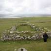
General view of pillar and enclosure.
RCAHMS Field Survey Digital Photography
25/6/2011
© Crown Copyright: HES

DP 138221
General view of pillar, enclosre and cairn.
RCAHMS Field Survey Digital Photography
25/6/2011
© Crown Copyright: HES

DP 138222
General view fo pillar, enclosure and cairn.
RCAHMS Field Survey Digital Photography
25/6/2011
© Crown Copyright: HES

DP 138223
General view of boundary dyke at NF 89 88, with Toe Head in the background.
RCAHMS Field Survey Digital Photography
25/6/2011
© Crown Copyright: HES

DP 138225
View of the eastern building in the farmstead (NF 90075 88526), taken from the NW.
RCAHMS Field Survey Digital Photography
25/6/2011
© Crown Copyright: HES

DP 138226
View of the central building in the farmstead (NF 90068 88519), taken from the N.
RCAHMS Field Survey Digital Photography
25/6/2011
© Crown Copyright: HES

DP 138227
View of hut, taken from the E.
RCAHMS Field Survey Digital Photography
25/6/2011
© Crown Copyright: HES

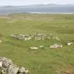
DP 138228
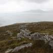
General view of possible dun, taken from the S.
RCAHMS Field Survey Digital Photography
25/6/2011
© Crown Copyright: HES

DP 138229
View of possible building in interior,
RCAHMS Field Survey Digital Photography
25/6/2011
© Crown Copyright: HES

DP 138230
View of possible building in interior,
RCAHMS Field Survey Digital Photography
25/6/2011
© Crown Copyright: HES

DP 138231
View of internal features,
RCAHMS Field Survey Digital Photography
25/6/2011
© Crown Copyright: HES

DP 138232
Detail of bank at SW side of mound,
RCAHMS Field Survey Digital Photography
25/6/2011
© Crown Copyright: HES

DP 138234
View of kiln barn,
RCAHMS Field Survey Digital Photography
25/6/2011
© Crown Copyright: HES

DP 138235
View of building,
RCAHMS Field Survey Digital Photography
25/6/2011
© Crown Copyright: HES

DP 138236
View of cairn from the SE,
RCAHMS Field Survey Digital Photography
25/6/2011
© Crown Copyright: HES

DP 138237
View of enclosure taken from the S,
RCAHMS Field Survey Digital Photography
25/6/2011
© Crown Copyright: HES

DP 138238
View of enclosure, taken from the S,
RCAHMS Field Survey Digital Photography
25/6/2011
© Crown Copyright: HES

DP 138239
View of enclosure taken from the N,
RCAHMS Field Survey Digital Photography
25/6/2011
© Crown Copyright: HES

DP 138240
View of enclosure taken from the NW,
RCAHMS Field Survey Digital Photography
25/6/2011
© Crown Copyright: HES

DP 138241
View of clearance cairn, taken from the E,
RCAHMS Field Survey Digital Photography
25/6/2011
© Crown Copyright: HES

DP 138242
View of clearance cairn, taken from the W,
RCAHMS Field Survey Digital Photography
25/6/2011
© Crown Copyright: HES

DP 138243
View of kiln-barn, from the SE,
RCAHMS Field Survey Digital Photography
25/6/2011
© Crown Copyright: HES

DP 138244
Position of recent test pit, and outer face of wall, taken from the NE,
RCAHMS Field Survey Digital Photography
26/6/2011
© Crown Copyright: HES

DP 138245
View of building to N of dun, taken from the S,
RCAHMS Field Survey Digital Photography
26/6/2011
© Crown Copyright: HES

DP 138246
General view from the N,
RCAHMS Field Survey Digital Photography
26/6/2011
© Crown Copyright: HES

DP 138247
View of building and enclosure at NF 8892 8746, taken from the SW,
RCAHMS Field Survey Digital Photography
26/6/2011
© Crown Copyright: HES

DP 138248
View of building at NF 8892 8746, taken from the S,
RCAHMS Field Survey Digital Photography
26/6/2011
© Crown Copyright: HES

DP 138249
Detail of entrance, taken from W,
RCAHMS Field Survey Digital Photography
26/6/2011
© Crown Copyright: HES

DP 138250
View of building, taken from S,
RCAHMS Field Survey Digital Photography
26/6/2011
© Crown Copyright: HES

DP 138251
View of building and enclosure, taken from the NW,
RCAHMS Field Survey Digital Photography
26/6/2011
© Crown Copyright: HES

DP 138252
View of kiln barn taken from the SE,
RCAHMS Field Survey Digital Photography
26/6/2011
© Crown Copyright: HES

DP 138253
Detail of kiln bowl,
RCAHMS Field Survey Digital Photography
26/6/2011
© Crown Copyright: HES

DP 138254
View of turf building, taken from the N,
RCAHMS Field Survey Digital Photography
26/6/2011
© Crown Copyright: HES

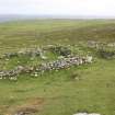
DP 138255
View of the exterior wall face of the possible dun,
RCAHMS Field Survey Digital Photography
26/6/2011
© Crown Copyright: HES

DP 138256
View of the possible intra-mural space,
RCAHMS Field Survey Digital Photography
26/6/2011
© Crown Copyright: HES

DP 138257
View of the possible intra-mural space,
RCAHMS Field Survey Digital Photography
26/6/2011
© Crown Copyright: HES

DP 138258
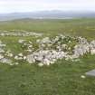
General view of possible dun, taken from the NW,
RCAHMS Field Survey Digital Photography
26/6/2011
© Crown Copyright: HES

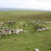
DP 138259
General view of possible dun, taken from the SW,
RCAHMS Field Survey Digital Photography
26/6/2011
© Crown Copyright: HES

DP 138260
General view of cairn, taken from the N,
RCAHMS Field Survey Digital Photography
26/6/2011
© Crown Copyright: HES

DP 138261
General view, taken from the E,
RCAHMS Field Survey Digital Photography
26/6/2011
© Crown Copyright: HES

DP 138262
View of hut, taken from the SW,
RCAHMS Field Survey Digital Photography
26/6/2011
© Crown Copyright: HES

DP 138263
General view from the E,
RCAHMS Field Survey Digital Photography
26/6/2011
© Crown Copyright: HES

DP 138264
View of hut, taken from the NW,
RCAHMS Field Survey Digital Photography
26/6/2011
© Crown Copyright: HES

DP 138265
View of hut, taken from the NW,
RCAHMS Field Survey Digital Photography
26/6/2011
© Crown Copyright: HES

DP 138266
General view, taken from the NW,
RCAHMS Field Survey Digital Photography
26/6/2011
© Crown Copyright: HES

DP 138267
General view, taken from the N,
RCAHMS Field Survey Digital Photography
26/6/2011
© Crown Copyright: HES

DP 138268
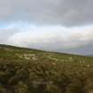
General view of the N side of Pabbay,
RCAHMS Field Survey Digital Photography
26/6/2011
© Crown Copyright: HES

DP 138269
General view of Shillay, taken from Pabbay,
RCAHMS Field Survey Digital Photography
26/6/2011
© Crown Copyright: HES

DP 138270
General view of Loch Heddal More,
RCAHMS Field Survey Digital Photography
26/6/2011
© Crown Copyright: HES

DP 138271
View of building, taken from the NW.
RCAHMS Field Survey Digital Photography
26/6/2011
© Crown Copyright: HES

DP 138272
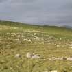
General view of cultivation remains looking towards Creag Thuriston, taken from the NE,
RCAHMS Field Survey Digital Photography
26/6/2011
© Crown Copyright: HES

DP 138273
General view looking towards the northern part of Baile Lingay, taken from the SW,
RCAHMS Field Survey Digital Photography
26/6/2011
© Crown Copyright: HES

DP 138274
General view looking down a bank towards Seana Chaisteal, taken from the NW,
RCAHMS Field Survey Digital Photography
26/6/2011
© Crown Copyright: HES

DP 138275
General view of the northern part of Baile Lingay, taken from the W,
RCAHMS Field Survey Digital Photography
26/6/2011
© Crown Copyright: HES

DP 138276
North Lingay. General view of modified building at NF 89319 87831, taken from the NW.
RCAHMS Field Survey Digital Photography
26/6/2011
© Crown Copyright: HES

DP 138277
North Lingay. General view of one building superimposed on the remains of another at NF 89336 87835, taken from the NE.
RCAHMS Field Survey Digital Photography
26/6/2011
© Crown Copyright: HES

DP 138278
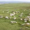
North Lingay. General view of the group of three buildings at NF 89340 87832.
RCAHMS Field Survey Digital Photography
26/6/2011
© Crown Copyright: HES

DP 138279
General view of building,
RCAHMS Field Survey Digital Photography
26/6/2011
© Crown Copyright: HES

DP 138280
General view of building,
RCAHMS Field Survey Digital Photography
26/6/2011
© Crown Copyright: HES

DP 138281
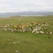
North Lingay. General view of group at NF 89384 87822, taken from the N.
RCAHMS Field Survey Digital Photography
26/6/2011
© Crown Copyright: HES

DP 138282
General view of building,
RCAHMS Field Survey Digital Photography
26/6/2011
© Crown Copyright: HES

DP 138283
General view of building,
RCAHMS Field Survey Digital Photography
26/6/2011
© Crown Copyright: HES

DP 138284
General view of building,
RCAHMS Field Survey Digital Photography
26/6/2011
© Crown Copyright: HES

DP 138285
General view of building,
RCAHMS Field Survey Digital Photography
26/6/2011
© Crown Copyright: HES

DP 138286
General view of building with fireplace at NF 89384 87576,
RCAHMS Field Survey Digital Photography
26/6/2011
© Crown Copyright: HES

DP 138287
General view of building,
RCAHMS Field Survey Digital Photography
26/6/2011
© Crown Copyright: HES

DP 138288
General view of building,
RCAHMS Field Survey Digital Photography
26/6/2011
© Crown Copyright: HES

DP 138289
General view of building,
RCAHMS Field Survey Digital Photography
26/6/2011
© Crown Copyright: HES

DP 138290
General view of building,
RCAHMS Field Survey Digital Photography
26/6/2011
© Crown Copyright: HES

DP 138291
General view of building,
RCAHMS Field Survey Digital Photography
26/6/2011
© Crown Copyright: HES

DP 138292
General view of building,
RCAHMS Field Survey Digital Photography
26/6/2011
© Crown Copyright: HES

DP 138293
General view of building,
RCAHMS Field Survey Digital Photography
26/6/2011
© Crown Copyright: HES

DP 138294
General view of buildings,
RCAHMS Field Survey Digital Photography
26/6/2011
© Crown Copyright: HES

DP 138295
General view of building,
RCAHMS Field Survey Digital Photography
26/6/2011
© Crown Copyright: HES

DP 138296
General view of building,
RCAHMS Field Survey Digital Photography
26/6/2011
© Crown Copyright: HES

DP 138297
Detail of kiln bowl in barn at NF 89391 87309,
RCAHMS Field Survey Digital Photography
26/6/2011
© Crown Copyright: HES

DP 138298
General view, from the N,
RCAHMS Field Survey Digital Photography
26/6/2011
© Crown Copyright: HES

DP 138299
View of possible cairn taken from the N,
RCAHMS Field Survey Digital Photography
26/6/2011
© Crown Copyright: HES

DP 138300
Detail of window in the S wall,
RCAHMS Field Survey Digital Photography
27/6/2011
© Crown Copyright: HES

DP 138301
View from the E
RCAHMS Field Survey Digital Photography
27/6/2011
© Crown Copyright: HES

DP 138302
Teampull Beag, subsumed within the cemetery mound, taken from the N,
RCAHMS Field Survey Digital Photography
27/6/2011
© Crown Copyright: HES

DP 138303
View of the shepherd's bothy and adjacent shepherd's house,
RCAHMS Field Survey Digital Photography
27/6/2011
© Crown Copyright: HES

DP 138304
General view of buildings at NF 8874 8606, taken from the SSE.
RCAHMS Field Survey Digital Photography
27/6/2011
© Crown Copyright: HES

DP 138305
General view of building at NF 88769 86977, taken from the NW,
RCAHMS Field Survey Digital Photography
27/6/2011
© Crown Copyright: HES

DP 304264
Map of Pabbay, showing the principal archaeological sites.
Historic Environment Scotland
31/7/2019
© Crown Copyright: HES