
Edinburgh University's Angus and South Aberdeenshire Field School


Ordnance Survey licence number AC0000807262. All rights reserved.
Canmore Disclaimer.
© Copyright and database right 2024.

| Event | Type | Subtype | Notes | Date |
|---|---|---|---|---|
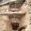
| 558093 | RECORDING | EXCAVATION | NO 555 668 (NO56NE 1) An archaeological survey and excavation were conducted at Brown Caterthun between August and October 1995 in response to evidence of substantial rabbit damage to the earthworks enclosing the hilltop. The principal motive for the fieldwork was to assess the extent of rabbit-derived erosion, as a basis for future implementation of ameliorative land management policies. The evaluative excavations have shown that the degree of rabbit (and other) damage to Brown Caterthun hillfort is at least as extensive as surface traces indicate and in many instances the erosion was more severe. A total of eight trenches (Trenches 1-8, Fig 34) with a combined area of c222 sq m, were investigated. [...] | August 1995 |
| 558095 | RECORDING | GROUND SURVEY | NO 555 668 (NO56NE 1) An archaeological survey and excavation were conducted at Brown Caterthun between August and October 1995 in response to evidence of substantial rabbit damage to the earthworks enclosing the hilltop. The principal motive for the fieldwork was to assess the extent of rabbit-derived erosion, as a basis for future implementation of ameliorative land management policies. The evaluative excavations have shown that the degree of rabbit (and other) damage to Brown Caterthun hillfort is at least as extensive as surface traces indicate and in many instances the erosion was more severe. A total of eight trenches (Trenches 1-8, Fig 34) with a combined area of c222 sq m, were investigated. [...] | August 1995 |
| 558094 | RECORDING | RESISTIVITY | NO 555 668 (NO56NE 1) An archaeological survey and excavation were conducted at Brown Caterthun between August and October 1995 in response to evidence of substantial rabbit damage to the earthworks enclosing the hilltop. The principal motive for the fieldwork was to assess the extent of rabbit-derived erosion, as a basis for future implementation of ameliorative land management policies. The evaluative excavations have shown that the degree of rabbit (and other) damage to Brown Caterthun hillfort is at least as extensive as surface traces indicate and in many instances the erosion was more severe. A total of eight trenches (Trenches 1-8, Fig 34) with a combined area of c222 sq m, were investigated. [...] | August 1995 |

SC 1120709
Excavation photographs: Film 23 from the 1995 season at Brown Caterthun. A length of heavily disturbed and disfigured Rampart F (where Trench 1 was excavated), from the north-east.
Historic Scotland Archive Project
1995
© Historic Scotland

SC 1120715
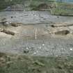
Excavation photographs: Film 62 from the 1996 season at Brown Caterthun. Trench 20, Enclosure A: entrance within palisade enclosure, from the south.
Historic Scotland Archive Project
6/8/1996
© Historic Scotland

SC 1120716
Excavation photographs: Film 66 from the 1996 season at Brown Caterthun. Wall B rear face, Trench 17.
Historic Scotland Archive Project
5/8/1996
© Historic Scotland

SC 1120717
Excavation photographs: Film 7 from the 1995 season at Brown Caterthun. Wall B front face, Trench 5.
Historic Scotland Archive Project
11/9/1995
© Historic Scotland

SC 1120718
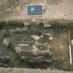
Excavation photographs: Film 21 from the 1995 season at Brown Caterthun. Trench 2, Rampart E: burnt timber deposit 6 from the north-east (outer rampart face to left). Note the rabbit burrow running obliquely through the timbers to the left of the small scale.
Historic Scotland Archive Project
15/9/1995
© Historic Scotland

SC 1120722
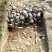
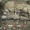
Excavation photographs: Film 91 from the 1996 season at Brown Caterthun. Trench 15, Rampart E: stone face of rampart and cobble alignment beneath rampart, from the south.
Historic Scotland Archive Project
11/9/1996
© Historic Scotland

SC 1120729
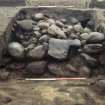
Excavation photographs: Film 68 from the 1996 season at Brown Caterthun. Trench 14: Rampart F, cobble layer, buried turf and posthole from the north-west.
Historic Scotland Archive Project
5/8/1996
© Historic Scotland

SC 1120730
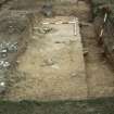
Excavation photographs: Film 68 from the 1996 season at Brown Caterthun. Trench 14: Rampart F and ditch from the east.
Historic Scotland Archive Project
5/8/1996
© Historic Scotland

SC 1120731
Excavation photographs: Film 72 from the 1996 season at Brown Caterthun. Trench 12, Rampart F: ditch terminal south of hte entrance, showing large rock-cut posthole in terminal, from the north.
Historic Scotland Archive Project
7/8/1996
© Historic Scotland

SC 1120732
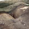
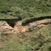
Excavation photographs: Film 56 from the 1996 season at Brown Caterthun. Trench 21: quarry scoop from the north-east. Within the scoop, to the left, the soil is shallow over bedrock; to the right, outside the scoop, the greater depth of soil can be seen in the stepped section. The irregular gully proved to be a natural feature.
Historic Scotland Archive Project
29/7/1996
© Historic Scotland
Excavation archive: Correspondence relating to tender process and acceptance, reports and publication of the excavations at Brown Caterthun.
Post-excavation archive: Radiocarbon application forms and result sheets from 1995 and 1996 excavations at Brown Caterthun.
Post-excavation archive: Specialist reports. Includes –Analysis of soil thin sections from Trenches 15 and 17; Soil thin section analysis; Coarse Pottery; Plan Macrofossil Analysis; Conservation of the iron arrowhead from Brown Caterthun; Iron knife fragment; Carbonise Wood; Carbonised wood studies report (contexts 008 and 058); Report on the on-site palynological analysis; Charcoal identification; Flint report; Coarse Stone Report; Geophysical Survey Report.
