Edinburgh University's Angus and South Aberdeenshire Field School


Date August 1995 - 1996
Event ID 558093
Category Recording
Type Excavation
Permalink http://canmore.org.uk/event/558093
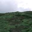
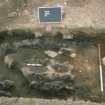
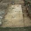
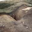
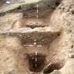
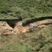
NO 555 668 (NO56NE 1) An archaeological survey and excavation were conducted at Brown Caterthun between August and October 1995 in response to evidence of substantial rabbit damage to the earthworks enclosing the hilltop. The principal motive for the fieldwork was to assess the extent of rabbit-derived erosion, as a basis for future implementation of ameliorative land management policies. The evaluative excavations have shown that the degree of rabbit (and other) damage to Brown Caterthun hillfort is at least as extensive as surface traces indicate and in many instances the erosion was more severe. A total of eight trenches (Trenches 1-8, Fig 34) with a combined area of c222 sq m, were investigated.
Trench 1 revealed the outermost rampart to be c2.9m wide, preserved only up to 0.4m high, and constructed as a simple dump rampart. The inner edge was sealed by cobbling. The outer edge of the rampart lay immediately beside a ditch which was revealed to be c2.3m wide, c1.6m deep and was rock-cut through bedded strata of soft red sandstone and conglomerates. The ditch was broadly V-shaped. A counterscarp bank lay c0.8m beyond the ditch. A decayed turf layer was sealed directly beneath the rampart.
Trench 2 exposed a rampart c4m wide and up to 0.8m high, of relatively complex construction. It consisted of a foundation of laid turfs, partially defined by two lines of boulders, upon which a raft of burnt timbers had been laid. The raft comprised a series of closely-spaced transversal timbers, and a longitudinal timber just within the outer boulder alignment, perhaps laid to consolidate the turf base and to provide a solid foundation for the upper parts of the rampart. The turf base was heavily scorched, suggesting that the timbers had burnt in situ. The upper part of the rampart comprises mainly a series of dumped deposits of sandy soil and angular chunks of sandstone, probably derived from redeposited subsoil and bedrock. A rough pebble surface abutted the inner side of the rampart.
Trench 3 revealed the rabbit damage to excavated deposits in this entrance passage to be less extensive than from surface traces. A complex sequence of deposits and stone alignments was identified, but not excavated. It appeared that the southern boundary of a putative paddock between the outermost two encircling works at this point was a secondary construction to the rampart. Post holes were identified adjacent to the northern rampart terminal which possibly reflect the presence of gateway features.
Trench 4 demonstrated that both the outer work and the rampart were of simple dump construction. A single post hole was located on the inturned bank, cut through the rampart deposits.
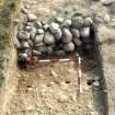
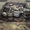
Trench 5 revealed the largest rampart encircling the hill to have a complex construction. A primary boulder core with an outer revetting face and rubble inner bank was identified. The remains of a hurdle breastwork which had burnt down and collapsed inwards was located on the summit of the capping. This rampart had subsequently been recapped with another turf layer. The ramparts running outside and parallel to this were demonstrated to be no more than low dumps. A palisade trench was identified 3m within the inner of the two, and a post hole sealed beneath a patch of cobbling abutted the outer dump.
Trench 6 demonstated the rampart to comprise a low bank of sandy soil containing a number of boulders spread to c3m wide and up to 0.4m high. Sealed or partly beneath the bank were two parallel palisade trenches c1.1m apart running approximately NE-SW and parallel to the bank. The northern palisade trench turned sharply northward within the trench, and possibly defining the position of an entrance. A laid cobble surface lay was sealed beneath a layer of sandy clay soil between the two palisades, above a possible buried turf line. At least two structural phases are proposed and the arrangement of the double palisade feature suggests the presence of a former box rampart with an inturned entrance. Trench 7 revealed a similar sequence.
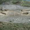
Trench 8 exposed the entrance passage, which was c7.5m long and 2.8m wide. Potential structural features identified within the entrance passage comprise a transverse double cobble alignment enclosing a probable slot, a pebble alignment running perpendicular to this and possibly related, and a negative linear feature with a distinct circular projection. Due to the complexity of features encountered in other trenches and the relatively less serious rabbit damage encountered in this trench little more than cleaning, photography and planning of the deturfed areas was attempted within the time available.
The excavation has shown that the erosion of the archaeological features by rabbit infestation is at least as damaging and in most cases more extensive than surface traces would indicate. A suite of samples was collected and an evaluation of the palaeoenvironmental potential of the site is being conducted. Trenches 1, 2, 5 and 7 produced charcoal deposits which should be identifiable and may be suitable for C14 dating. Finds from the site were limited to two small flint pieces and modern debris.
Sponsor: Historic Scotland.
A J Dunwell and R Strachan 1995.
Further rescue and research excavations have been undertaken at Brown Caterthun (NMRS NO 56 NE 1), a monument in the care of the Secretary of State for Scotland which is suffering severely from the effects of rabbit burrowing (Dunwell and Strachan 1995) for the excavation of Trenches 1-8). Only trenches with results of particular interest are detailed below.
Trench 23 was excavated across a shallow depression on the summit of the hill, generally regarded as the site of a spring. A rock-cut bowl c 3m in diameter by 0.8m deep was revealed; two phases of use were indicated by a recutting of the bowl. The recut feature was filled by a silt rich in burnt grain and charcoal, possibly indicating a function associated with crop processing.
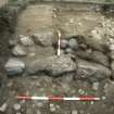
Trench 20 was excavated across the S entrance and immediate interior of the inner enclosure, extending Trench 6. The enclosure was originally defined by a low upcast bank, into which two concentric and parallel palisade slots were cut c 1m apart. These palisade slots defined a gated entrance-way c 2m wide. A primary layer of well-laid cobbling was revealed below the enclosing bank. A spread of rough cobbles was defined within the entrance-way and extended within the enclosure. A number of pits, post-holes and lengths of a curvilinear slot identified within the enclosure probably relate to structural remains, but no coherent patterns could be observed.
Trench 19 investigated whether the surface indications of a hut platform, one of several on the upper E slopes of the hill, was confirmed by sub-surface remains. The truncated remains of 11 post-holes and two discontinuous arcs of narrow slots were recorded, which probably represent elements of a timber structure. Hearth waste and pottery were recovered.
Trench 17 revealed the largest rampart encircling the hill to be very similar in constructional detail to that identified in Trench 5, comprising a stone wall surmounted by a scorched turf or earth cap. An alignment of four small post-holes ran beside the inside face of the wall. Samples of alder and willow charcoal recovered from the collapsed breastwork in Trench 5 have provided radiocarbon dates (1d) of 488-395 cal BC (GU-4599) and 488-392 cal BC (GU-4600).
Trench 16 examined an entrance passage through the largest encircling work, expanding Trench 8. The rampart terminals defining the passage were of similar construction as identified in Trenches 5 and 17. The cobbled entrance passage was c 2.7m wide and was lined by six post-holes arranged in three opposing pairs, the central pair being the largest. Two parallel and intermittent palisade trenches c 3.5m apart approached the entrance from the E (exterior). Parts of these alignments were sealed below the rampart terminals, indicating that the entrance-way had two structural phases.
Trench 15 investigated a section of the rampart previously examined in Trench 2, revealing it to be here composed of a series of mixed subsoil dumps and grey, silty, charcoal-rich deposits revetted on the exterior by a boulder face backed by cobbles. A curvilinear alignment of cobbles ran beneath the rampart core, and either represents part of the rampart construction itself or the remains of an earlier structure.
Trench 13 extended Trench 3 to investigate the whole of an entrance and adjacent rampart terminals of the second outermost encircling work. The rampart was of similar form to that revealed in Trench 2, although here two discrete levels of burnt timbers were identified, the lower of branches and the upper of small roundwood. A rock-cut terrace lay immediately outside the rampart, increasing the height of the external face of the rampart. Four rock-cut post-holes defined the position of a gateway. A secondary stone alignment and a low upcast bank defined an avenue leading uphill to the entrance. Samples of birch and alder charcoal obtained from the timber layer within the rampart excavated in Trench 2 have provided radiocarbon dates (1d) of 765-408 cal BC (GU-4602), 762-406 cal BC (GU-4603), and 779-515 cal BC (GU-4604).
Trench 14 investigated a section of the outermost rampart and rock-cut ditch previously examined in Trench 1. These earthworks were structurally as identified in Trench 1, although there was possible evidence of a recut within the upper ditch fills and of a bedding trench on the crest of the rampart. The slight remains of a counterscarp bank and a curvilinear palisade slot were located immediately outside the ditch. This latter may be part of a structure truncated by the rampart and ditch. A sample of hazel charcoal obtained from the buried turf layer sealed below the rampart in Trench 1 has provided a radiocarbon date (1d) of 394-207 cal BC (GU-4601).
Trench 12 expanded Trench 4 to investigate the whole of the E entrance through the outermost encircling works. The cobbled entrance passage was revealed to be 2.8m wide, and to contain no certain evidence for a gate structure. The rampart and ditch defining the N side of the entrance inturned markedly, and were abutted by a secondary bank extending uphill towards the Trench 13 entrance. A cobble-filled gully ran between the two ditch termini, probably representing a drainage feature.
A Data Structure Report, including details of trenches not reported here, has been produced; a copy is with the NMRS.
Sponsors: Historic Scotland, Edinburgh University.
A J Dunwell and R Strachan 1996.