Measured Survey
Date 11 May 1988 - 13 May 1988
Event ID 1109584
Category Recording
Type Measured Survey
Permalink http://canmore.org.uk/event/1109584
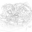
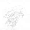
RCAHMS surveyed the fort and cultivation terraces at Dundurn on 11-13 May 1988 at a scale of 1:500, using a Wild self-reducing alidade and plane-table. The survey comprised five individual plan drawings (DC11840-11844), brought together as a master plan (DC 11839). This plan was redrawn in ink (DC11845) and published at a reduced scale in 1995 (Walker and Ritchie 1995, p.164). Detailed (1:10) drawings of the rock cut slots were also produced.


