
Pricing Change
New pricing for orders of material from this site will come into place shortly. Charges for supply of digital images, digitisation on demand, prints and licensing will be altered.
Upcoming Maintenance
Please be advised that this website will undergo scheduled maintenance on the following dates:
Thursday, 9 January: 11:00 AM - 3:00 PM
Thursday, 23 January: 11:00 AM - 3:00 PM
Thursday, 30 January: 11:00 AM - 3:00 PM
During these times, some functionality such as image purchasing may be temporarily unavailable. We apologise for any inconvenience this may cause.
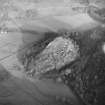
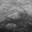
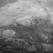
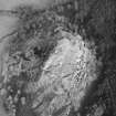
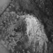
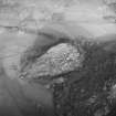
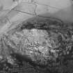
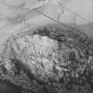
Dundurn


Cultivation Terrace(S) (Period Unknown)
Site Name Dundurn
Classification Cultivation Terrace(S) (Period Unknown)
Alternative Name(s) St Fillan's Hill
Canmore ID 24879
Site Number NN72SW 9
NGR NN 7068 2326
Datum OSGB36 - NGR
Permalink http://canmore.org.uk/site/24879


- Council Perth And Kinross
- Parish Comrie (Perth And Kinross)
- Former Region Tayside
- Former District Perth And Kinross
- Former County Perthshire
NN72SW 9 7068 2326.
(NN 706 232) Cultivation terraces on the W slope of St Fillan's Hill, below fortifications of Dundurn (NN72SW 3).
A Graham 1939
These terraces (at least 4) are centred on NN 7068 2326. Their working areas are narrow, that of the best preserved, the easternmost, being only 3.0m wide while its scarp is 2.2m high. There are faint indications of a bank on two of them and the possibility cannot be ruled out that these 'terraces' are, in fact, outworks of Dundurn Fort (NN72SW 3).
Surveyed at 1/2500.
Visited by OS (EGC) 9 December 1966
Not outworks, but cultivation terraces, as described.
Visited by OS (MJF) 3 September 1980
Measured Survey (11 May 1988 - 13 May 1988)
RCAHMS surveyed the fort and cultivation terraces at Dundurn on 11-13 May 1988 at a scale of 1:500, using a Wild self-reducing alidade and plane-table. The survey comprised five individual plan drawings (DC11840-11844), brought together as a master plan (DC 11839). This plan was redrawn in ink (DC11845) and published at a reduced scale in 1995 (Walker and Ritchie 1995, p.164). Detailed (1:10) drawings of the rock cut slots were also produced.

