
Pricing Change
New pricing for orders of material from this site will come into place shortly. Charges for supply of digital images, digitisation on demand, prints and licensing will be altered.
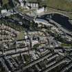
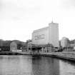
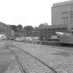
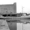
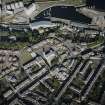
Kirkcaldy, The Path, Ravenscraig Maltings


Maltings (Period Unassigned)
Site Name Kirkcaldy, The Path, Ravenscraig Maltings
Classification Maltings (Period Unassigned)
Alternative Name(s) Harbour Maltings; Robert Hutchison And Company Limited
Canmore ID 79888
Site Number NT29SE 68
NGR NT 286 922
NGR Description NT 2871 9234, NT 2858 9226 and NT 2857 9216
Datum OSGB36 - NGR
Permalink http://canmore.org.uk/site/79888


- Council Fife
- Parish Kirkcaldy And Dysart
- Former Region Fife
- Former District Kirkcaldy
- Former County Fife
NT29SE 68 286 922, 2871 9234, 2858 9226 and 2857 9216.
see Architecture
(Location cited as NT 287 923). Maltings, mid to late 19th century and later. Large group of rubble buildings, mainly 3 and 4 storey, with 3 pyramidal-roofed kilns and 2 conical-roofed kilns.
J R Hume 1976.
See also, Kirkcaldy, The Path, East Bridge Flour Mills
Aerial Photography (1966)
Oblique aerial photographs of Ravenscraig Castle and the surrounding area of Kirkcaldy, Fife, photographed by John Dewar in 1966.

