
Easter Happrew


Roman Fort (Roman)
Site Name Easter Happrew
Classification Roman Fort (Roman)
Canmore ID 50032
Site Number NT14SE 1
NGR NT 19469 40111
Datum OSGB36 - NGR
Permalink http://canmore.org.uk/site/50032


- Council Scottish Borders, The
- Parish Stobo
- Former Region Borders
- Former District Tweeddale
- Former County Peebles-shire
NT14SE 1 NT 19469 40111
(Name: NT 1940 4010) Roman Fort (R) (site of)
(NT 1955 4018) Roman Buildings (R) (site of)
OS 6" map (1963)
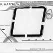
This fort was first discovered on APs (F 2182/RAF/1270, 49-51) in 1955 and excavated in 1956, when it was shown to be rhomboidal in plan, measuring 380' each way within the rampart, enclosing just under 3 1/2 acres, appropriate to an infantry regiment 500 strong.
The defences consisted of a turf rampart, 25'6" thick, the front portion of which rested on a stone pitching, and a single ditch, 12' wide by 5' deep. This latter feature was probably omitted on the N side, where the rampart, itself now partly eroded, was drawn along the edge of a steep scarp. Three gates are visible on APs, in the E, S, and W sides respectively, but the E and W gates are not exactly opposite each other: as shown on plan, there may have been a fourth gate in the N side. Only a portion of the praetorium was examined. It lay immediately N of the E gate, showing that the fort faced S, and was built of wattle-and-daub on a timber framework. Like the defences, it showed no signs of reconstruction.
The gravel used for surfacing the roads in and around the fort was obtained from a quarry near the E defences, while beyond the quarry,
APs showed traces of three timber-framed buildings, one of which (2 on plan), may have been a mansio. These buildings do not seem to have been enclosed, unless a ditch photographed by St Joseph (AP AAK 25) in the next field to the E is part of a contemporary defence, but another AP (ACJ 14), shows a small annexe to the W side of the fort, enclosed by a narrow ditch, measuring c. 200' E-W by 160' N-S, with an entrance in the N.
All the dateable relics recovered - pottery, glass, and a sestertius of Vespasian, were late 1st century AD, and it seems likely that this fort was established during the Agricolan invasion, and it may have been abandoned in favour of Lyne (NT14SE 4) shortly after AD 86.
RCAHMS 1967, visited 1962
When field investigated in 1961, no trace of this fort could be seen, the area being under crop.
Visited by OS (EGC) 28 July 1961
As described. There is no trace of the fort on the ground.
Site surveyed at 1:2500.
Visited by OS (DWR) 5 July 1971
Photographed by the RCAHMS in 1976 and 1977.
NT 196 401 (fort) Casual finds over a number of years indicate the presence of Roman activity, perhaps annexes and a vicus, around the fort at Easter Happrew and on the low-lying ground below it. All datable finds confirm Flavian activity. The finds are in Scottish Borders Museums; full details are held by NMS.
F Hunter 1999
Reference (1957)
This site is noted in the ‘List of monuments discovered during the survey of marginal land (1951-5)’ (RCAHMS 1957, xiv-xviii).
Information from RCAHMS (GFG), 24 October 2012.
Field Visit (4 September 2017)
A historic environment assessment and survey was required by SAC Consulting to inform a programme of tree planting across a number of areas at Easter Happrew, Peebles, Scottish Borders (centred on NT 1738 4145). These works were designed to inform on the nature, form and extent of any historic environment assets present within the defined area based on archival sources and site inspection through the walkover survey. From this baseline, management guidelines are presented that seek to protect significant sites in an appropriate setting.
This process identified eleven historic environment sites relating to the assessment area. One of these was protected for its significance, the Scheduled Monument Easter Happrew Roman Fort (SM1493).
Infromation from Rathmell Archaeology Ltd.
Sbc Note
Visibility: This site has been excavated.
Information from Scottish Borders Council

