
Pricing Change
New pricing for orders of material from this site will come into place shortly. Charges for supply of digital images, digitisation on demand, prints and licensing will be altered.
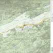
Auchendavy; Antonine Wall


Frontier Defence (Roman), Roman Fort (Roman)
Site Name Auchendavy; Antonine Wall
Classification Frontier Defence (Roman), Roman Fort (Roman)
Alternative Name(s) Auchendavy-hillhead; Auchendavie Farm
Canmore ID 45201
Site Number NS67SE 12
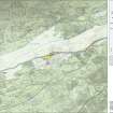
NGR NS 67763 74920
Datum OSGB36 - NGR
Permalink http://canmore.org.uk/site/45201


- Council East Dunbartonshire
- Parish Kirkintilloch (Strathkelvin)
- Former Region Strathclyde
- Former District Strathkelvin
- Former County Dunbartonshire
NS67SE 12.00 67763 74920
(NS 6775 7495) Roman Fort (R)
OS 6" map, (1967)
NS67SE 12.01 NS 674 750 Enclosures
See also NS67SW 22.
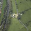
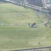
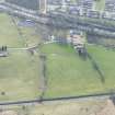
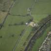
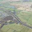
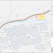
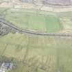
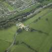
The area of the Roman fort at Auchendavy is now bisected by the Kilsyth road, which here may override the Military Way, and within it there lies the farmhouse of Auchendavy, north of the road, with the farm steading south of the road. It is probable that the Forth-Clyde Canal has partly destroyed the southern defences of the fort. Horsley states that the fort was enclosed by a triple rampart and ditch, but it is now almost obliterated. However, enough remains to confirm Roy's measurements of about 370' x 330' internally. Air photography (St Joseph 1951) has revealed two ditches along part of the E and S sides, and the SE angle of the fort. Coins, including a gold aureus of Trajan (98 - 117), a deposit of ballista bullets, five altars, four of which were set up by a centurion of the Second Legion, Marcus Cocceius Firmus, a stone bust, and two iron mallets, have been found here, also a small intaglio (now in the National Museum of Antiquities of Scotland [NMAS]). (See also NS67SE 18.)
J Horsley 1732; W Roy 1793; G Macdonald 1934; J K St Joseph 1951; A S Robertson 1973.
A broad, shallow, ill-defined depression represents the E side and SE corner of the Auchendavy Roman Fort. The hollow measures 20.0m - 30.0m in width, and 1.0m in maximum depth. A broad, unsurveyable mound follows this on the outer side. There are no surface indications of the ditches noted by St Joseph (1951) and no information regarding any fresh discoveries was obtained locally.
Visited by OS (J L D) 11 January 1957.
NS 677 749. During ploughing operations, a quantity of Roman sherds - pieces of amphora, coarse ware, samian ware, and flue tiles, were recovered.
Cumbernauld Hist Soc 1974.
NS 6775 7493 A magnetic survey of 2.8ha to the E and W of the fort in May 2006 continued previous work at the site. Anomalies detected to the E of the fort were unlikely to be Roman in origin, but those abutting the NE corner were more encouraging. On the W side further detail was obtained on the area enclosed by the fort's ramparts and a possible second, more westerly, line of defences. Conductivity was used on an experimental basis.
Location of archive to be determined.
Sponsor: EU Culture 2000.
Richard Jones, 2006.
NS 6775 7493 The magnetic survey carried out in July 2007 extended the work previously carried out (see DES 2006) in the large field W of the fort, giving an overall coverage of 5.5ha. The course of the ditch was followed across the full extent of the field. Survey N of the ditch towards the River Kelvin revealed nothing that could be clearly regarded as Roman; in particular, in the area excavated in advance of the sewer pipe line (Dunwell et al PSAS 2002, 13) little evidence was found for the presence there of Roman period ditches. The most interesting location was the c100m W from the fort's western ditches. Work now continues in two directions, first in distinguishing features of Roman origin
from those of later date among the plethora of features detected in this area. Second, the rich GPR data set from the same area is being interpreted; the subsurface plans obtained at different depths appear most promising and should be informative.
Archive location not yet decided.
Funder: EU Culture 2000: Frontiers of the Roman Empire project.
Richard Jones, 2007.
Scheduled [from NS c, 6734 7488 to NS c. 6782 7503] as 'Antonine Wall and fort, 130m NE to 375m WSW of Auchendavie Farm...'
Information from Historic Scotland, scheduling document dated 23 November 2010.
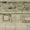
Antiquarian Observation (1726)
Gordon desrcibes and maps the site.
Information from RCAHMS (JB) 14 November 2008
Antiquarian Observation (1793)
Roy recorded the location and size of the fort.
W Roy 1793
Aerial Photography (29 July 1945)
Air photography (St Joseph 1951) has revealed two ditches along part of the E and S sides, and the SE angle of the fort.
J K St Joseph 1951
Field Visit (11 January 1957)
A broad, shallow, ill-defined depression represents the E side and SE corner of the Auchendavy Roman Fort. The hollow measures 20.0m - 30.0m in width, and 1.0m in maximum depth. A broad, unsurveyable mound follows this on the outer side. There are no surface indications of the ditches noted by St Joseph (1951) and no information regarding any fresh discoveries was obtained locally.
Visited by OS (J L D) 11 January 1957.
Artefact Recovery (1974)
NS 677 749. During ploughing operations, a quantity of Roman sherds - pieces of amphora, coarse ware, samian ware, and flue tiles, were recovered.
Cumbernauld Hist Soc 1974.
Note (1982)
Auchendavy, Fort NS 677 7 49 NS67SE 12
Situated on the Antonine Wall, a little over 1km ENE of Kirkintilloch and immediately N of the Forth and Clyde canal, this fort appears to have measured internally about 110m by 100m (1.1 ha). Much of the interior is occupied by the farmhouse and steading of Auchendavy, and the site is further traversed by the modern road leading from Twechar to Kirkintilloch. No archaeological excavation has taken place here, but the fort clearly abuts the S face of the Rampart, and early plans show it to have been defended by triple ditches. During the construction of the adjacent canal in 1771, a remarkable cache of five Roman altars was discovered in a pit on the S side of the fort. The tombstones found at nearby Shirva (NS76NE 13) may have come from the cemetery associated with the fort.
RCAHMS 1982
(Macdonald 1934, 285-9; Robertson 1979, 73)
Magnetometry (2006)
NS 6775 7493 A magnetic survey of 2.8ha to the E and W of the fort in May 2006 continued previous work at the site. Anomalies detected to the E of the fort were unlikely to be Roman in origin, but those abutting the NE corner were more encouraging. On the W side further detail was obtained on the area enclosed by the fort's ramparts and a possible second, more westerly, line of defences. Conductivity was used on an experimental basis.
Location of archive to be determined.
Sponsor: EU Culture 2000.
Richard Jones, 2006.
Magnetometry (July 2007)
NS 6775 7493 The magnetic survey carried out in July 2007 extended the work previously carried out (see DES 2006) in the large field W of the fort, giving an overall coverage of 5.5ha. The course of the ditch was followed across the full extent of the field. Survey N of the ditch towards the River Kelvin revealed nothing that could be clearly regarded as Roman; in particular, in the area excavated in advance of the sewer pipe line (Dunwell et al PSAS 2002, 13) little evidence was found for the presence there of Roman period ditches. The most interesting location was the c100m W from the fort's western ditches. Work now continues in two directions, first in distinguishing features of Roman origin
from those of later date among the plethora of features detected in this area. Second, the rich GPR data set from the same area is being interpreted; the subsurface plans obtained at different depths appear most promising and should be informative.
Archive location not yet decided.
Funder: EU Culture 2000: Frontiers of the Roman Empire project.
Ground Penetrating Radar (July 2007)
NS 6775 7493 The magnetic survey carried out in July 2007 extended the work previously carried out (see DES 2006) in the large field W of the fort, giving an overall coverage of 5.5ha. The course of the ditch was followed across the full extent of the field. Survey N of the ditch towards the River Kelvin revealed nothing that could be clearly regarded as Roman; in particular, in the area excavated in advance of the sewer pipe line (Dunwell et al PSAS 2002, 13) little evidence was found for the presence there of Roman period ditches. The most interesting location was the c100m W from the fort's western ditches. Work now continues in two directions, first in distinguishing features of Roman origin
from those of later date among the plethora of features detected in this area. Second, the rich GPR data set from the same area is being interpreted; the subsurface plans obtained at different depths appear most promising and should be informative.
Archive location not yet decided.
Funder: EU Culture 2000: Frontiers of the Roman Empire project.
Publication Account (2008)
A 1:25000 scale map of the Antonine Wall was published by RCAHMS in 2008. The map shows the course of the Antonine Wall on a modern map base, including areas where the Wall is in public ownership or care and can be visited. The data had been collated as part of the project to prepare maps for the World Heritage Site nomination bid.
Project

