|
Photographs and Off-line Digital Images |
B 34001 CN |
|
Mappa Britanniae Faciei Romanae. Plate II from "Military Antiquities of the Romans in Britain" |
1793 |
Item Level |
|
|
Photographs and Off-line Digital Images |
B 34002 CN |
|
Albion et Hibernia. Plate III from "Military Antiquities of the Romans in Britain" |
1793 |
Item Level |
|
|
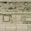
Photographs and Off-line Digital Images |
B 34032 CN |
Copies from a collection of drawings assembled by the Society of Antiquaries of London, London, Engl |
Plan showing the course of the Roman Wall called Grime's Dyke (Antonine Wall). Plate XXXV from 'Military Antiquities of the Romans in Britain'. |
1793 |
Item Level |
|
|
Photographs and Off-line Digital Images |
B 34032 CS |
Copies from a collection of drawings assembled by the Society of Antiquaries of London, London, Engl |
Plan showing the course of the Roman Wall called Grime's Dyke (Antonine Wall). Plate XXXV from 'Military Antiquities of the Romans in Britain'. |
1793 |
Item Level |
|
|
Photographs and Off-line Digital Images |
DB 750 PO |
Cambridge University Collection for Aerial Photography |
|
29/7/1945 |
Item Level |
|
|
Photographs and Off-line Digital Images |
DB 884 PO |
Cambridge University Collection for Aerial Photography |
|
29/7/1945 |
Item Level |
|
|
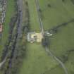
Photographs and Off-line Digital Images |
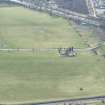
D 86704 CS |
RCAHMS Aerial Photography |
Oblique aerial view of Auchendavy centred on the site of a Roman fort and the Antonine wall, taken from the E. |
25/9/1997 |
Item Level |
|
|
Photographs and Off-line Digital Images |
D 86705 CS |
RCAHMS Aerial Photography |
Oblique aerial view of Auchendavy centred on the site of a Roman fort and the Antonine wall, taken from the N. |
25/9/1997 |
Item Level |
|
|
Photographs and Off-line Digital Images |
D 86706 CS |
RCAHMS Aerial Photography |
Oblique aerial view of Auchendavy centred on the site of a Roman fort and the Antonine wall, taken from the NW. |
25/9/1997 |
Item Level |
|
 |
On-line Digital Images |
SC 732701 |
Copies from a collection of drawings assembled by the Society of Antiquaries of London, London, Engl |
Plan showing the course of the Roman Wall called Grime's Dyke (Antonine Wall). Plate XXXV from 'Military Antiquities of the Romans in Britain'. |
1793 |
Item Level |
|
|
Photographs and Off-line Digital Images |
DP 006858 |
|
Digital image of plan of the Roman Fort at Auchendavy showing layout of ditches. |
|
Item Level |
|
|
Photographs and Off-line Digital Images |
DC 47351/12 |
Records of the Ordnance Survey, Southampton, Hampshire, England |
Ordnance Survey 6-inch to the mile Provisional Edition, Revision of 1910 and 1914 with additions in 1938.
Additional annotations by Ordnance Survey for the Antonine Wall map covering the parishes of Kirkibtilloch and Cadder with |
c. 1938 |
Item Level |
|
 |
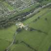
On-line Digital Images |
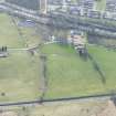
DP 020978 |
RCAHMS Aerial Photography Digital |
Oblique aerial view centred on the site of the Roman fort and the course of the Antonine Wall and the military way, taken from the E. |
8/9/2006 |
Item Level |
|
 |
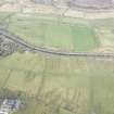
On-line Digital Images |
DP 020979 |
RCAHMS Aerial Photography Digital |
Oblique aerial view centred on the site of the Roman fort and the course of the Antonine Wall and the military way, taken from the NE. |
8/9/2006 |
Item Level |
|
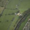 |
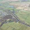
On-line Digital Images |
DP 020980 |
RCAHMS Aerial Photography Digital |
SW oblique aerial view of Auchendavy Roman fort and the course of the Antonine Wall and the military way. |
8/9/2006 |
Item Level |
|
 |
On-line Digital Images |
DP 249578 |
Historic Environment Scotland |
Oblique aerial view. |
24/3/2017 |
Item Level |
|
 |
On-line Digital Images |
DP 249579 |
Historic Environment Scotland |
Oblique aerial view. |
24/3/2017 |
Item Level |
|
 |
On-line Digital Images |
DP 249667 |
Historic Environment Scotland |
Oblique aerial view. |
24/3/2017 |
Item Level |
|
 |
On-line Digital Images |
DP 249668 |
Historic Environment Scotland |
Oblique aerial view. |
24/3/2017 |
Item Level |
|
|
Photographs and Off-line Digital Images |
SC 1913428 |
Cambridge University Collection for Aerial Photography |
|
29/7/1945 |
Item Level |
|
|
Photographs and Off-line Digital Images |
SC 1913430 |
Cambridge University Collection for Aerial Photography |
|
29/7/1945 |
Item Level |
|
|
Digital Files (Non-image) |
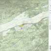
GV 007521 |
Records of Historic Scotland, Edinburgh, Scotland |
Map 5 of 8 from IV.I 1-8 - Series 1: Maps of the Antonine Wall at a scale of 1:25000 showing the proposed World Heritage Site, known forts and fortlets, camps, other features and the buffer zones. Maps were prepared for the nomination document to propose the extension of the Frontiers of the Roman Empire World Heritage Site through the addition of the Antonine Wall. |
2006 |
Item Level |
|
 |
On-line Digital Images |
SC 1926557 |
Records of Historic Scotland, Edinburgh, Scotland |
Map 5 of 8 from IV.I 1-8 - Series 1: Maps of the Antonine Wall at a scale of 1:25000 showing the proposed World Heritage Site, known forts and fortlets, camps, other features and the buffer zones. Maps were prepared for the nomination document to propose the extension of the Frontiers of the Roman Empire World Heritage Site through the addition of the Antonine Wall. |
2006 |
Item Level |
|
|
Digital Files (Non-image) |
GV 007528 |
Records of Historic Scotland, Edinburgh, Scotland |
Map 5 of 8 from IV.2 1-8 - Series 2: Maps of the Antonine Wall at a scale of 1:25000 showing the proposed World Heritage Site, known forts and fortlets, camps, other features and the buffer zones. Maps were prepared for the nomination document to propose the extension of the Frontiers of the Roman Empire World Heritage Site through the addition of the Antonine Wall. |
2006 |
Item Level |
|


