
Pricing Change
New pricing for orders of material from this site will come into place shortly. Charges for supply of digital images, digitisation on demand, prints and licensing will be altered.
Upcoming Maintenance
Please be advised that this website will undergo scheduled maintenance on the following dates:
Thursday, 9 January: 11:00 AM - 3:00 PM
Thursday, 23 January: 11:00 AM - 3:00 PM
Thursday, 30 January: 11:00 AM - 3:00 PM
During these times, some functionality such as image purchasing may be temporarily unavailable. We apologise for any inconvenience this may cause.
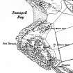
Bute, Dunagoil


Fort (Prehistoric), Axehead (Stone)(Period Unassigned), Mould (Clay)(Period Unassigned), Ring (Bronze)(Period Unassigned)
Site Name Bute, Dunagoil
Classification Fort (Prehistoric), Axehead (Stone)(Period Unassigned), Mould (Clay)(Period Unassigned), Ring (Bronze)(Period Unassigned)
Canmore ID 40291
Site Number NS05SE 4
NGR NS 08479 53127
Datum OSGB36 - NGR
Permalink http://canmore.org.uk/site/40291


- Council Argyll And Bute
- Parish Kingarth
- Former Region Strathclyde
- Former District Argyll And Bute
- Former County Buteshire
Field Visit (25 May 1943)
This site was included within the RCAHMS Emergency Survey (1942-3), an unpublished rescue project. Site descriptions, organised by county, vary from short notes to lengthy and full descriptions and are available to view online with contemporary sketches and photographs. The original typescripts, manuscripts, notebooks and photographs can also be consulted in the RCAHMS Search Room.
Information from RCAHMS (GFG) 10 December 2014.
Reference (1971)
Bronze spiral finger-ring reconstructed from fragments.
E W MacKie 1971.
Field Visit (16 July 1975)
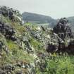
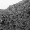
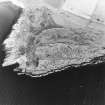
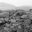
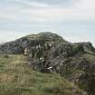
A fort with a single wall which follows the margin of the summit area and is heavily vitrified along the seaward side. According to Dorothy Marshall, Ludovic Mann concluded that the E end had been rebuilt, since it was found to incorporate re-used vitrified material.
Information from K A Steer, 16 July 1975.
Desk Based Assessment (17 June 1976)
Dunagoil fort, 300 ft x 75 ft, occupies a headland which is virtually inaccessible except from the inland side. It was defended by a timber-laced stone rampart, vitrified after catching fire. Following this destruction the fort was reoccupied, for pieces of the vitrified rock were incorporated into a later cross-wall which reduced the size of the original fort. The vitrifaction is best seen at the NW corner of the fort where a small part of the wall still stands, elsewhere it has tumbled down, masses of vitrified rock being found on the slope. On the S side an 8ft wide gap in the wall, half-way along, suggests an entrance. This gap, lined on either side by a wall, is now filled with loose stones. Marshall (1915), who carried out excavations here in 1913-5, considers that there was another entrance in the E, leading to a gap in the cliff face. A great many artifacts including polished stone axe heads, ring-headed pins of bronze and iron, an Early Iron Age brooch, glass and lignite bracelets, coarse pottery, a Late Bronze Age stone mould, crucibles, spindle whorls etc, were found during the excavation. (Other excavations were carried out in 1919 and 1925). They are now in Rothesay Museum. Scott (1966) suggests that the fort may have been built about 200 BC, and occupied until 100 AD.
Information from OS (IF) 17 June 1976.
Sources: J N Marshall 1915; J G Scott 1966; L M Mann 1925; J M Coles 1962.
Field Visit (21 November 1976)
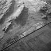
The remains of this vitrified fort at Dunagoil (name confirmed) are generally as described in the previous information. The wall in the extreme NW corner, as well as being a good example of vitrifaction also has a length of outer face visible. There is no inner face remaining however and no thickness of wall can be determined. The walling on the E is grass-covered but appears to have been 3.5m in width. Excavation on this side has exposed a short length of wall face running transversely to the main wall and possibly representing an entrance. A similar gap has been exposed in the middle of the S side where the wall is only recognisable as a low grass-covered scarp. Some turf has been lifted from the middle of the fort to uncover a considerable amount of loose stone. There is however no trace of the later cross wall mentioned in the previous information.
Surveyed at 1:10 000.
Visited by OS (B S) 21 November 1976.
Reference (1981)
(Clay mould for unclassified socketed axe). Single find. Fragment of clay mould for socketed axe (?), only blade remaining. Max. width 70mm. Rothesay Museum; cast in National Museum of Antiquities of Scotland [NMAS], CM 45.
P K Schmidt and C B Burgess 1981.
Reference (1988)
The stone axe that is held in Bute Museum, Rothesay, under accession number 1919.A.45 has been petrologically identified as 'near' to group IX (porcellanite from Tievebulliagh and Rathlin, Northern Ireland).
T H McK Clough and W A Cummins 1988.
Measured Survey (1994 - 1995)
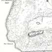
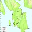
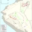
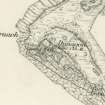
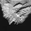
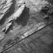
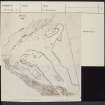
NS 086 533-084 531 A second season of survey work was carried out on the site of the two forts at Dunagoil on the SW coast of the Isle of Bute. This season saw the completion of the detailed topographic survey of an area measuring c1000m by 500m, and allowed comprehensive three-dimensional models to be formed to aid in the understanding of the location and topography of the sites.
A further stage of field work will be required for verification of the features surveyed before publication.
D W Harding, I Ralston and C Burgess 1995
Reference (1997)
Field Visit (December 2003)
This site was noted during a coastal zone assessment survey undertaken by CFA Archaeology Ltd to characterise the state of coastal erosion and the threat it poses to cultural heritage sites. A gazetteer in the report included a note of existing records and new sites when discovered. Where the site was located, notes included condition, period/date and recommendations.
Commissioned by The Scape Trust and Firth of Clyde Forum on behalf of Historic Scotland.
M Cressey and M Johnson 2004
Field Visit (20 March 2009)
The remains of the fort on Dunagoil, which was first mapped in detail by Peter or Alexander May in 1780, are generally as described by the OS in 1976, and the significance of the site and the artefacts found in it to Iron Age studies has recently been reviewed by Harding (2004).
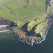
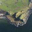
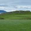
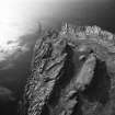
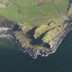
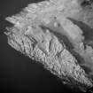
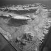
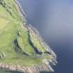
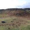
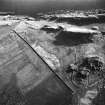
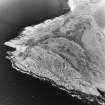
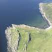
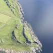
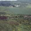
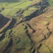
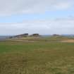
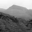
At a height of 35m above sea level, the fort sits at the NW end of a craggy basalt ridge with vertical cliffs on the NE and NW, a steep, uneven, drop to the sea on the SW and a gentle, but very irregular, descent to a natural cove some 200m to the SE. The fort measures about 85m from NW to SE by up to 20m transversely within the cliff-edge on the NW and NE and a ruinous timber-laced wall elsewhere that measures up to about 3.5m in thickness. The SW side is characterised by the presence of a large mass of in situ vitrified wall-core along much of its length and it is broken by an entrance about midway. There is what appears to be another entrance (revealed in an excavation trench) in the SE end, where the fort wall runs on to the edge of the precipice on the NE before turning and extending along the cliff-top for a distance of about 10m. There is no evidence that there was any form of wall along the remaining length of the NE side and the NW end, but at a distance of about 35m from the SE end a crevice that would have afforded relatively easy access to the summit has been blocked by a drystone revetment, the outer face of which stands to a height of at least 0.7m. Another blocked crevice, this time outside the fort some 75m to the SE, may have been designed to hinder progress towards the fort from that direction. It lies on the line of easiest access to the summit from the lower terrace and the cove, and even today the blocking stands up to about 1m in height. Apart from excavation trenches, the interior of the fort is featureless.
Harding (2004) has recently argued that the terrace immediately NE of the fort formed some kind of contemporary ‘bailey’. Whilst this area is defined by natural features linked by comparatively short lengths of thick stone wall, the vitrified stone that was observed in these walls on the date of visit seems to be in re-use, representing material that has either been robbed from the earlier timber-laced wall or tumble that has fallen down the slope from the ruinous fort. In addition to the probable prehistoric burial cairns (NS05SE 13) within this area, there are extensive remains of later cultivation (NS05SE 29) that include rig-and-furrow and clearance cairns.
Other features in the vicinity of the fort include a possible stance for a timber round-house (NS 08509 53052), dug into the SW-facing slope 50m S of the E end of the fort. It measures about 5m in diameter and it may be associated with a series of stony banks close-by that form small enclosures.
Visited by RCAHMS (GFG, AGCH, ARG) 20 March 2009.
Publication Account (2009)
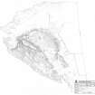
The archaeological complex at Dunagoil includes the vitrified fort, Little Dunagoil fort, caves and middens, cultivation remains and the buildings at the foot of Little Dunagoil. Dunagoil fort is an iconic site, which includes one of the richest collections of multi-period, small finds ranging from flint artefacts and Bronze Age spear butt moulds to a La Tene 1c type brooch. In 1995 an extensive survey of the site was undertaken by the University of Edinburgh. The resultant survey plan was included in Professor Dennis Harding’s review of the site published in the Transactions of the Buteshire Natural History Society in 2002.
The published plan was derived from a data terrain model, which provided a contour plot of the site. The plan does not clearly differentiate between natural features such as cliffs and manmade structural elements of the fort. One aim for the RCAHMS team will be to revise the plan of the site, perhaps re-working the original 1995 survey, using the latest ortho-rectified, vertical aerial photography. This will be undertaken in conjunction with the local groups and individuals, as part of the second phase of RCAHMS project of site record enhancement and will allow them to re-engage with this iconic monument.
Information from ‘The Royal Commission on the Ancient and Historical Monuments of Scotland, Commissioners’ Field Meeting 2009'.
Measured Survey (17 March 2010 - 18 March 2010)
RCAHMS created a field survey plan of the fort at Dunagoil, Bute between 17-18 March 2010 at a scale of 1:1250. It was created using gGPS field survey data, orthorectified 25cm aerial photographs, and the survey of Burgess and Henderson.
Note (11 July 2014 - 23 May 2016)
The fort at Dunagoil occupies a craggy ridge on the coast S of Dunagoil Bay. The ridge is aligned ESE and WNW, dropping precipitously on the NNE and WNW, so much so that, the only defensive work along the cliff-edge is a short section of masonry with its outer face still 0.7m high blocking a gully leading up to the crest. Elsewhere the defences comprise a substantial wall some 3.6m thick which displays massive vitrifaction of its core the length of the SSW side. A run of the outer face is visible at the northern end of this side, but nothing can be seen of the inner face. There is also an entrance midway along this side, and another in the ESE end, where the wall measures 3.3m in thickness and cuts sharply back over the crest of the ridge to return a short distance along the cliff-edge on the NNE. The interior, which measures about 85m in length from ESE to WNW by up to 20m transversely (0.15ha), is featureless, and nothing can now be seen of the cross-wall noted on an estate plan of 1780 (Bute Archive). Excavations were carried out in 1914 and 1915, and again in 1919, though the results have been reported in only the most sketchy outline (Mann 1915; 1925; Marshall 1915). Nevertheless, several details indicate that the history of occupation on the hilltop included more than the construction and destruction of the fort. John Marshall, digging a trench into the masonry at the top of the gully on the NNE found chunks of vitrified stone reused in its fabric, from which he concluded that it was constructed after the main wall was destroyed (Marshall 1915, 45-6). This may have influenced Ludovic Mann's assertion that the fort had been extended eastwards at some point in its history, claiming that the new wall overlay midden from an earlier occupation, though whether this is an allusion to Marshall's trench on the E or an observation of his own of the main wall, as he implies, towards the ESE end of the fort is unclear (Mann 1925, 60). Nevertheless, the various trenches provided one of the richest assemblages of artefacts found in any fort in western Scotland, with a wide range of materials and evidence of metalworking (Mann 1915; 1925).
Information from An Atlas of Hillforts of Great Britain and Ireland – 23 May 2016. Atlas of Hillforts SC1201

