Measured Survey


Date 17 March 2010 - 18 March 2010
Event ID 1152185
Category Recording
Type Measured Survey
Permalink http://canmore.org.uk/event/1152185
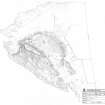
RCAHMS created a field survey plan of the fort at Dunagoil, Bute between 17-18 March 2010 at a scale of 1:1250. It was created using gGPS field survey data, orthorectified 25cm aerial photographs, and the survey of Burgess and Henderson.