
Pricing Change
New pricing for orders of material from this site will come into place shortly. Charges for supply of digital images, digitisation on demand, prints and licensing will be altered.
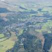
Bochastle


Roman Fort (Roman)
Site Name Bochastle
Classification Roman Fort (Roman)
Canmore ID 24337
Site Number NN60NW 17
NGR NN 61415 07912
NGR Description Centre
Datum OSGB36 - NGR
Permalink http://canmore.org.uk/site/24337


- Council Stirling
- Parish Callander
- Former Region Central
- Former District Stirling
- Former County Perthshire
NN60NW 17 centred 6142 0790.
(NN 6142 0790) Roman Fort (R) (remains of)
OS 1:10,000 map, (1979)
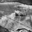
Early writers have referred to a 'Roman Camp' at Bochastle and in 1949 excavations began on the site. The earthwork was found to be an original quadrate Roman fort (occupying an area of about 3 ha) with a rampart built on a turf base, with a single ditch outside it and normal entrances in the centre of each side. At some period (whether during occupation or not is uncertain) destruction or damage led to the reconstruction of the NE corner, together with part of the E rampart and the N part of the W rampart. The internal arrangements of the fort have not yet been discovered, nor has the principia been located. Pottery and other finds, although few, indicate a 1st century date and undoubted Agricolan origin.
W A Anderson, C Taylor and A Sommerville 1956.
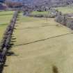
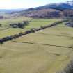
NN 6142 0790. The best-preserved feature of this fort is the W rampart, turf-covered, in places 2.7m high, with a well-defined entrance. The road shown on the plan by Authy 2 at the E of the entrance is defined by a low, spread mound, 0.7m high in places, which probably extended round the S side of the fort to a point opposite the W entrance where it turns sharply to join the W rampart. Several of the finds from the site are in the Hunterian Museum, Glasgow.
Surveyed at 1:2500.
Visited by OS (E G C) 24 October 1968.
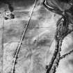
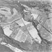
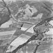
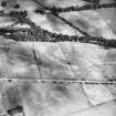
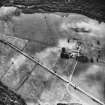
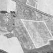
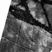
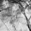
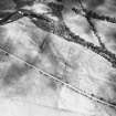
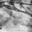
Crop-marks reveal two ditches defining some 500ft of the E side of the fort, interrupted at the E gate where they curve inwards. The rounded SE angle lies wholly N of the railway to Callander, and the S side would appear to converge very gradually with the railway embankment. The NE angle of the fort and perhaps all the N defences have been destroyed by river erosion.
J K St Joseph 1969.
Photographed by the RCAHMS.
Visible on RCAHMS air photographs (see archive).
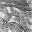
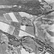
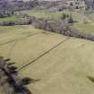
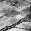
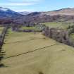
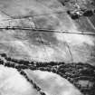
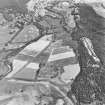
The Roman fort at Bochastle lies just to the N of the dismantled railway, about 200m NE of Bochastle farm. Part of the W side of the fort is upstanding but the evidence for the rest consists of cropmark remains. The internal dimensions of the fort are about 170m N-S by 140m E-W. Some internal features are visible.
Transcription prepared by RCAHMS (RHM, MMB & GSM) 22 February 1996.
Information from RCAHMS (RHM) 17 September 1996.
NN 614 079 Resistance and magnetic surveys were conducted over the entire fort and its surroundings. The results contradict various unusual features described in the report on the excavations in the 1950s (1). The survey confirmed aerial evidence of a double ditch circuit with 'parrot beak' gate breaks. The NW and SW corners had survived encroachment by the River Teith and a railway cutting. Despite the excavators' claims to the contrary, however, the NE corner had been eroded by the river. More importantly, the magnetic survey detected clear foundation traces for some of the main range of buildings, whereas the excavation claimed that the interior features had been destroyed by an incursion of the river. The site is thus significantly better preserved than had been thought. One aspect of the excavation plan was strikingly vindicated, however, for the rampart showed deep (up to 26m) re-entrants at all four gates. These fit well with the parrot beak ditch breaks and would have formed an enfiladed killing ground in front of the gates.
The survey confirmed air photographic hints that the fort and temporary camp ditches might intersect. The two thus seem unlikely to be contemporary. The upcast from the fort ditches obscures the camp ditch where the two cross, which might suggest that the camp was built first. Trenching was conducted on the camp's W defences to determine which of three possible ditch lines, seen from the air, was the real camp ditch. All proved to be V-shaped ditches and two had been re-cut. No dating evidence was recovered to prove that all were indeed Roman, but if so they would suggest a complex occupation history. On the other hand, trenching close to the camp's SE corner demonstrated that an aerial feature which had seemed to be an annexe was natural in origin. Here, however, more modern traces of metalworking were found, including iron blooms, furnaces and furnace waste.
Two other post-Roman features were surveyed; a group of lime kilns to the W of the fort and a large oval stone revetted platform in the centre of the camp, which had been cut into during the construction of the modern Bochastle farm.
Sponsor: the Roman Gask Project.
D J Woolliscroft and B Hoffmann, 2006.
Field Visit (December 1977)
Bochastle 1 NN 614 079 NN60NW 17
Excavation has shown that this Roman fort, which occupies an area of about 3ha, dates from the 1st century AD. The W rampart stands to a height of 2. 7m, and the rest of the defences have been recorded as crop-marks.
RCAHMS 1979, visited December 1977
(Anderson, Taylor and Sommerville 1956)
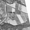
Aerial Photographic Transcription (28 November 1995 - 1 May 1996)
An aerial transcription was produced from oblique aerial photographs. Information from Historic Environment Scotland (BM) 31 March 2017.
Geophysical Survey (2006)
NN 614 079 Resistance and magnetic surveys were conducted over the entire fort and its surroundings. The results contradict various unusual features described in the report on the excavations in the 1950s (1). The survey confirmed aerial evidence of a double ditch circuit with 'parrot beak' gate breaks. The NW and SW corners had survived encroachment by the River Teith and a railway cutting. Despite the excavators' claims to the contrary, however, the NE corner had been eroded by the river. More importantly, the magnetic survey detected clear foundation traces for some of the main range of buildings, whereas the excavation claimed that the interior features had been destroyed by an incursion of the river. The site is thus significantly better preserved than had been thought. One aspect of the excavation plan was strikingly vindicated, however, for the rampart showed deep (up to 26m) re-entrants at all four gates. These fit well with the parrot beak ditch breaks and would have formed an enfiladed killing ground in front of the gates.
The survey confirmed air photographic hints that the fort and temporary camp ditches might intersect. The two thus seem unlikely to be contemporary. The upcast from the fort ditches obscures the camp ditch where the two cross, which might suggest that the camp was built first. Trenching was conducted on the camp's W defences to determine which of three possible ditch lines, seen from the air, was the real camp ditch. All proved to be V-shaped ditches and two had been re-cut. No dating evidence was recovered to prove that all were indeed Roman, but if so they would suggest a complex occupation history. On the other hand, trenching close to the camp's SE corner demonstrated that an aerial feature which had seemed to be an annexe was natural in origin. Here, however, more modern traces of metalworking were found, including iron blooms, furnaces and furnace waste.
Two other post-Roman features were surveyed; a group of lime kilns to the W of the fort and a large oval stone revetted platform in the centre of the camp, which had been cut into during the construction of the modern Bochastle farm.
Sponsor: the Roman Gask Project.
D J Woolliscroft and B Hoffman 2006
Note (21 November 2022)
The location, classification and period of this site have been reviewed.

