
North Sutor, Coast Battery


Building (Second World War)
Site Name North Sutor, Coast Battery
Classification Building (Second World War)
Alternative Name(s) Cromarty Defences, Fort North Sutor, Site No. 1
Canmore ID 364208
Site Number NH86NW 9.96
NGR NH 81920 68969
Datum OSGB36 - NGR
Permalink http://canmore.org.uk/site/364208


- Council Highland
- Parish Nigg (Ross And Cromarty)
- Former Region Highland
- Former District Ross And Cromarty
- Former County Ross And Cromarty
Field Visit (26 March 2019)
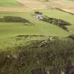
This courtyard-like building, which formed part of the camp introduced by the Army to sustain the battery during the Second World War, is situated 9.5m ENE of the NAAFI (NH86NW 9.93) and immediately SSE of the track leading from the North Sutor Land Service Battery Site No.1 to Site No.2 (NH86NW 9.48). Its most distinctive component is a moss-grown concrete platform on the NNW, which is terraced back into the rising ground on the SSE. It is rectangular on plan and measures 18m from ENE to WSW by 7.6m transversely over a brick plinth 0.23m thick and up to 0.75m high. Although the platform is underpinned with rubble, square concrete pillars interrupting the brickwork mark the location of the vertical slots for wooden posts which originally supported a timber superstructure. There is a threshold roughly midway along the NNW wall, indicating a former entrance from the track. On the ENE and WSW sides of the court each building measures roughly 11m from NNW to SSE by 4m transversely, but they are situated at a slightly lower level with a double step down on the ENE and a single step down on the WSW. The concrete floors of both are moss- and grass-grown, while a pile of concrete rubble partly overlies the inner wall-line on the ENE. The building on the SSE side of the court measures at least 7m from WSW to ENE and 5.5m transversely. It is heavily grass-grown and partly overlain with rubble, and it is by no means clear how far it originally extended to the ENE.
The building is annotated ‘Cookhouse’ on an undated sketch map entitled ‘Layout of Fort North Sutor’ within the Fort Record Book held in The National Archives at Kew (WO192/248). It is also depicted on two RAF aerial photographs (106G/RAF/0751/6039-40) flown on 31 August 1945. They show one building occupying the platform on the NNW, another on the SSE stopping short of the ENE side and a third occupying the courtyard to which access was had from the WSW.
Visited by HES, Survey and Recording (ATW, AKK), 26 March 2019

