
Pricing Change
New pricing for orders of material from this site will come into place shortly. Charges for supply of digital images, digitisation on demand, prints and licensing will be altered.
Cnoc Achadh Na H-uaighe


Hut (Period Unknown), Hut Circle(S) (Prehistoric)
Site Name Cnoc Achadh Na H-uaighe
Classification Hut (Period Unknown), Hut Circle(S) (Prehistoric)
Canmore ID 5853
Site Number NC70NW 17
NGR NC 7135 0751
NGR Description NC 7134 0751 and NC 7133 0752
Datum OSGB36 - NGR
Permalink http://canmore.org.uk/site/5853


- Council Highland
- Parish Rogart
- Former Region Highland
- Former District Sutherland
- Former County Sutherland
NC70NW 17 7135 0751 and 7133 0752
(A: NC 7135 0751 and B: NC 7133 0752) Hut Circles (NR)
OS 1;10,000 map, (1970)
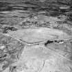
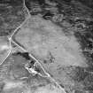
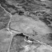
Two hut circles (A and B). In front of 'A' indications of another similar construction; the banks on either side entrance passage in 'B' square-ended. One or two small mounds lie in the immediate vicinity. RCAHMS 1911, visited 1909.
2 huts surveyed at 1:2500.
Visited by OS (R B) 1 February 1966.
'A' and 'B' are not hut circles, but enclosures associated with either the abandoned strip-cultivation in the vicinity or with the local tradition of a shieling area. Six metres SW of 'A' is a bothy-type footing 4.0 by 4.0m. There are no mounds of particular note. The enclosures each measure about 5.0m diameter within turf-covered walling standing on average to 0.5m high and where best preserved, in 'A' indicating a width of little over 1m. The enclosures have a simple entrance in the W. There is a tumble of bare stones in the interior of 'A'.
Revised at 1:10,000.
Visited by OS (J M) 6 April 1981.
Field Visit (8 March 1995)
Two small hut-circles (ROG95 31, 32) are situated on a peat-covered terrace on the WNW flank of Cnoc Achadh na h-Uaighe. The first (NC 7135 0751, ROG95 32, OS 'A') measures 4.9m from WSW to ESE by 4.4m transversely within a boulder-faced bank 1.2m in thickness and 0.4m in height. The entrance is on the WSW, and a heap of vegetation-free stones in the interior may the product of clearance. The second hut-circle (NC 7133 0752, ROG95 31, OS 'B') measures 4.9m from NE to SW by 4m transversely within a stony bank spread to 1.3m in thickness and 0.4m in height, with the entrance on the SW. A rectangular hut (NC 7134 0750, ROG95 920), measuring 3.9m from NNE to SSW by 2.5m internally, is situated on a terrace to the SW of the hut-circles.
(ROG95 31, 32, 920)
Visited by RCAHMS (DCC) 8 March 1995

