|
All Other |
MS 731/17 |
Records of the Royal Commission on the Ancient and Historical Monuments of Scotland (RCAHMS), Edinbu |
Afforestable Land Survey field database (Rogart survey, 1995). Held as attribute table in GIS and in Oracle Field/AP table. Please see DX001425 |
1995 |
Item Level |
|
|
Photographs and Off-line Digital Images |
C 46019 |
RCAHMS Aerial Photography |
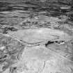
Cnoc Achad na h-Uaighe, Achnahuie, oblique aerial view, taken from the SW, showing an area defined as an archaeological landscape, various hut-circles, huts, small cairns and the remains of a building. |
13/6/1995 |
Item Level |
|
|
Photographs and Off-line Digital Images |
C 46020 |
RCAHMS Aerial Photography |
Cnoc Achad na h-Uaighe, Achnahuie, oblique aerial view, taken from the S, showing an area defined as an archaeological landscape, various hut-circles, huts, small cairns and the remains of a building. |
13/6/1995 |
Item Level |
|
|
Photographs and Off-line Digital Images |
C 46021 |
RCAHMS Aerial Photography |
Cnoc Achad na h-Uaighe, Achnahuie, oblique aerial view, taken from the SE, centred on an area defined as an archaeological landscape, an area with a hut-circle, small cairns, lynchets and a possible hut and the remains of a building. Hut-circles and a hut are visible in the upper left-hand corner. |
13/6/1995 |
Item Level |
|
|
Photographs and Off-line Digital Images |
B 97918 CS |
RCAHMS Aerial Photography |
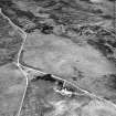
Cnoc Achad na h-Uaighe, Achnahuie, East Langwell, oblique aerial view, taken from the NW, centred on an area defined as an archaeological landscape, the remains of a building, a hut-circle, lynchets, small cairns and a possible hut. The remains of a building and small cairns is visible in the upper right-hand corner of the photograph, as is an area with hut-circles and a hut in the bottom right-hand corner. |
13/6/1995 |
Item Level |
|
|
Photographs and Off-line Digital Images |
B 97919 CS |
RCAHMS Aerial Photography |
Cnoc Achadh na h-Uaighe, Achnahuie, oblique aerial view, taken from the WNW, showing an area defined as an archaeological landscape, various hut-circles, huts and small cairns and the remains of a building. |
13/6/1995 |
Item Level |
|
|
Photographs and Off-line Digital Images |
B 97921 CS |
RCAHMS Aerial Photography |
Cnoc Achadh na h-Uaighe, Achnahuie, oblique aerial view, taken from the SE, showing an area defined as an archaeological landscape, various hut-circles, huts and small cairns, and the remains of a building. |
13/6/1995 |
Item Level |
|
 |
On-line Digital Images |
SC 1692929 |
RCAHMS Aerial Photography |
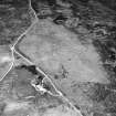
Cnoc Achad na h-Uaighe, Achnahuie, oblique aerial view, taken from the SW, showing an area defined as an archaeological landscape, various hut-circles, huts, small cairns and the remains of a building. |
13/6/1995 |
Item Level |
|
 |
On-line Digital Images |
SC 1692930 |
RCAHMS Aerial Photography |
Cnoc Achad na h-Uaighe, Achnahuie, oblique aerial view, taken from the S, showing an area defined as an archaeological landscape, various hut-circles, huts, small cairns and the remains of a building. |
13/6/1995 |
Item Level |
|
 |
On-line Digital Images |
SC 1692931 |
RCAHMS Aerial Photography |
Cnoc Achad na h-Uaighe, Achnahuie, oblique aerial view, taken from the SE, centred on an area defined as an archaeological landscape, an area with a hut-circle, small cairns, lynchets and a possible hut and the remains of a building. Hut-circles and a hut are visible in the upper left-hand corner. |
13/6/1995 |
Item Level |
|
|
Digital Files (Non-image) |
DX 001425 |
Records of the Royal Commission on the Ancient and Historical Monuments of Scotland (RCAHMS), Edinbu |
RCAHMS Structures Database - Rogart |
1995 |
Item Level |
|
|
Digital Files (Non-image) |
TM 000355 |
Records of the Royal Commission on the Ancient and Historical Monuments of Scotland (RCAHMS), Edinbu |
Zip file containing all survey linework collected during the RCAHMS Afforestable Land Survey of the Rogart area 1995. |
1995 |
Item Level |
|
 |
On-line Digital Images |
SC 2348498 |
Records of the Ordnance Survey, Southampton, Hampshire, England |
Cnoc Achadh Na H-Uaighe, NC70NW 17, Ordnance Survey index card, page number 1, Recto |
c. 1958 |
Item Level |
|
|
Digital Files (Non-image) |
TM 002205 |
Records of the Royal Commission on the Ancient and Historical Monuments of Scotland (RCAHMS), Edinbu |
Zip file containing all survey linework collected during the RCAHMS Afforestable Land Survey of the Rogart area 1995. SHP and Geojson file formats with extra attribution added to the linework. |
1995 |
Item Level |
|
|
All Other |
551 166/1/1 |
Records of the Ordnance Survey, Southampton, Hampshire, England |
Archaeological site card index ('495' cards) |
1947 |
Sub-Group Level |
|


