
Cnoc Achadh Na H-uaighe


Hut (Period Unknown), Hut Circle(S) (Prehistoric)
Site Name Cnoc Achadh Na H-uaighe
Classification Hut (Period Unknown), Hut Circle(S) (Prehistoric)
Canmore ID 5853
Site Number NC70NW 17
NGR NC 7135 0751
NGR Description NC 7134 0751 and NC 7133 0752
Datum OSGB36 - NGR
Permalink http://canmore.org.uk/site/5853


- Council Highland
- Parish Rogart
- Former Region Highland
- Former District Sutherland
- Former County Sutherland
NC70NW 17 7135 0751 and 7133 0752
(A: NC 7135 0751 and B: NC 7133 0752) Hut Circles (NR)
OS 1;10,000 map, (1970)
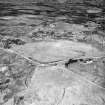
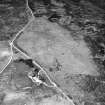
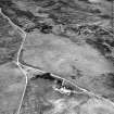
Two hut circles (A and B). In front of 'A' indications of another similar construction; the banks on either side entrance passage in 'B' square-ended. One or two small mounds lie in the immediate vicinity. RCAHMS 1911, visited 1909.
2 huts surveyed at 1:2500.
Visited by OS (R B) 1 February 1966.
'A' and 'B' are not hut circles, but enclosures associated with either the abandoned strip-cultivation in the vicinity or with the local tradition of a shieling area. Six metres SW of 'A' is a bothy-type footing 4.0 by 4.0m. There are no mounds of particular note. The enclosures each measure about 5.0m diameter within turf-covered walling standing on average to 0.5m high and where best preserved, in 'A' indicating a width of little over 1m. The enclosures have a simple entrance in the W. There is a tumble of bare stones in the interior of 'A'.
Revised at 1:10,000.
Visited by OS (J M) 6 April 1981.
Field Visit (8 March 1995)
Two small hut-circles (ROG95 31, 32) are situated on a peat-covered terrace on the WNW flank of Cnoc Achadh na h-Uaighe. The first (NC 7135 0751, ROG95 32, OS 'A') measures 4.9m from WSW to ESE by 4.4m transversely within a boulder-faced bank 1.2m in thickness and 0.4m in height. The entrance is on the WSW, and a heap of vegetation-free stones in the interior may the product of clearance. The second hut-circle (NC 7133 0752, ROG95 31, OS 'B') measures 4.9m from NE to SW by 4m transversely within a stony bank spread to 1.3m in thickness and 0.4m in height, with the entrance on the SW. A rectangular hut (NC 7134 0750, ROG95 920), measuring 3.9m from NNE to SSW by 2.5m internally, is situated on a terrace to the SW of the hut-circles.
(ROG95 31, 32, 920)
Visited by RCAHMS (DCC) 8 March 1995

