
Pricing Change
New pricing for orders of material from this site will come into place shortly. Charges for supply of digital images, digitisation on demand, prints and licensing will be altered.
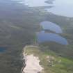
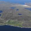
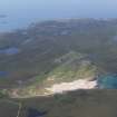
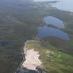
Achnahaird Sands


Building(S) (Medieval) - (Post Medieval), Building (Norse)(Possible), Cairn (Early Medieval), Enclosure (Period Unknown), Lambing Pen (Post Medieval), Midden(S) (Post Medieval), Sheepfold (Post Medieval), Slag, Unidentified Pottery (Medieval)
Site Name Achnahaird Sands
Classification Building(S) (Medieval) - (Post Medieval), Building (Norse)(Possible), Cairn (Early Medieval), Enclosure (Period Unknown), Lambing Pen (Post Medieval), Midden(S) (Post Medieval), Sheepfold (Post Medieval), Slag, Unidentified Pottery (Medieval)
Canmore ID 4488
Site Number NC01SW 2
NGR NC 0167 1314
Datum OSGB36 - NGR
Permalink http://canmore.org.uk/site/4488


- Council Highland
- Parish Lochbroom
- Former Region Highland
- Former District Ross And Cromarty
- Former County Ross And Cromarty
NC01SW 2 0167 1314.
NC 018 133. At Achnahaird Sands in an area of coastal sand dunes lie traces of human occupation. Numerous shell heaps, charcoal patches, and several hearths were seen. A nucleus of dry-stone foundations indicate a structure composed of a circular wall about 18' in diameter with a rectangular annexe indicated by a kerb of large stones running into a sand-face. Fragments of coarse pottery were found widely scattered, along with a number of flakes of flint. Two hammer stones were found, one extensively abraded at both ends, and a neatly made spindle whorl.
A chipping floor has been exposed by high winds. The occurrence of iron slag and the lower half of a rotary quern in the proximity of the foundations and shell heaps suggest a period for some of the remains, but the occupation of this area was probably over a long period of time. Sherds of hand-made pottery, possibly medieval, from a shell heap at NC 018 132, which were donated to the National Museum of Antiquities of Scotland (NMAS) in 1962-3 by C F Tebbutt, Eynesbury, seem to confirm this.
R Crerar 1969; Proc Soc Antiq Scot 1965.
At NC 0167 1314, a structure has been gradually exposed in an eroding sand dune over a period of 40 years. This is undoubtedly the nucleus of foundations seen by Crerar. It is now visible as a dry-stone walled rectangular enclosure with a curving E end, measuring 6.5m E-W by 4.0m N-S within a wall 1.3m thick. A small rectangular pen has been recently built in the interior. From near its SE corner a thin wall of stones on edge curves away to the SW for 13.0m, before it disappears into the dune. Two other walls, both running W from the SW and NW corners, also disappear into the dune. A straight line of stones crossing these latter walls from NW to SE is the foundation of a recent iron fence.
The walls stand on an old land surface and around them are scattered many fragments of iron slag, some fire cracked stones and pieces of charcoal; there are also several different sized heaps of stones, of uncertain provenance. A sherd of thin grey pottery was picked up by the Field surveyor close to the enclosure, and two sherds of thin red ware were found 80m to the N, together with a beach pebble used as a hammer stone.
Surveyed at 1:2500.
Visited by OS (A A) 18 July 1974.
Mr and Mrs Kirby (Mr and Mrs J Kirby, 3 ferry Croft, Lairg, Sutherland) found a bronze ring brooch (14th - 15th c AD), two small medieval sherds, and much slag "in the immediate vicinity of the rectangular stone buildings". They also found a bronze pin (perhaps 9th - 14th c AD) "from the side of a small rivulet at NC 018 134, and not associated with any structure or midden deposit". The finds are in the NMAS.
Information contained in Letter from J Close-Brooks (NMAS) 4 May 1976.
Field Visit (11 August 1994)
Two buildings and an enclosure, a scatter of artefacts, and a cairn are visible in the eroding sand-dunes about 100m to the E of Achnahaird farmsteading. In addition, there are several stone-covered middens, which contain 19th century artefacts, about 100m to the NNW of the steading.
The buildings are aligned on the same axis, WNW to ESE, about 20m apart, with the enclosure attached to the S of the more easterly of the two. The W building is boat-shaped and is exposed to damage by both natural and human processes, whilst that to the E is still partly grass-covered, although it, too, is progressively being uncovered by the winter-storms. The boat-shaped building has a rounded WNW end and what appears to be a squared ESE end. It measures 12.4m by 7.0m over faced-rubble footings, measuring 1.1m thick and up to 0.4m high with an entrance on the NNE. A row of stones on the W of the entrance and another on the opposite side of the building may mark the edge of a platform about 1m wide on both sides of the building. Its plan is reminiscent of a building excavated at Drimore on South Uist (NF74SE 5; MacLaren 1974). The second building is larger, measuring 16.6m by 7.2m over faced-rubble walls 1.3m thick and, where best-preserved, stands up to 0.6m high in four courses. The exposed part of the interior displays what may be a partition, and under the ESE end there are traces of an earlier structure, predating the enclosure that adjoins the S of the building. The exposed surfaces of the buildings and yard are scattered with artefacts including unglazed medieval or post-medieval pottery, shattered pot-boilers, molluscs, bird and animal bone, and a polished stone disc.
About 50m to the ENE of the buildings (NC 0171 1315) there is a square mound capped with boulders, 4m across and 1m high, which may be a burial cairn (ACHIL94 479).
About 100m to the NW (centred on NC 0160 1322) there are several mounds of stone and modern rubbish or varying shapes from large round through oblong to small round heaps in groups. The remains of a wire fence that formed a boundary of one of the fields of Achnahaird Farm run across the site from NW to SE.
(ACHIL94 477-9)
Visited by RCAHMS (PJD) 11 August 1994
Measured Survey (11 August 1994)
RCAHMS surveyed the Norse building at Achnahaird Sands with alidade and plane-table on 11 August 1994 at a scale of 1:100. The resultant plan was redrawn in ink and published at a scale of 1:200 (RCAHMS 1997c).
Measured Survey (1996)
NC 017 132 A basic plan of the site was produced as part of a coastal erosion survey between Ullapool and Lochinver and a postgraduate research project at Glasgow University. The site has experienced steady coastal erosion over a period of 30 years (DES 1969, 1974, 1976 and 1985) and recent sand movement has exposed paving, hearths and a land surface and a second subrectangular building with curved walls to the W of the previously documented structural complex. An attempt has been made to determine the period of occupation and activities practised at the site by compiling an inventory of artefacts collected from the site. The artefact assemblage consists primarily of hand-made pottery sherds, copper-alloy offcuts and artefacts, worked steatite, lithics and metalworking waste. the artefacts suggest a late prehistoric to post-medieval occupation for the site, with significant industrial activity in the 14th to 17th centuries. Further information on this site is currently being sought.
A Long 1996
Excavation (2000)
NC 0167 1314 An archaeological excavation was undertaken on the occupation site of Achnahaird Sands (NMRS NC 01 SW 2) due to the very heavy erosion of sand dunes. The area has seen finds being made over the last 30 years (DES 1969, 46; 1976, 76; 1996, 69).
The excavation revealed a small farmstead consisting of two buildings, forming one house and one house with byre and enclosure wall. The latter building was reused partially as a sheep fank with a lambing pen of a late 18th or early 19th-century date, with a boundary wall and clearance cairn. The second building revealed hearths, internal stone fittings and a beaten clay floor, likely to be late 17th century in date.
Within part of the enclosure wall was an area of paving and a hearth, with signs of possible metalworking. Outwith the main area of excavation a hearth was partly revealed and a number of buried land surfaces.
Finds made during the course of the excavation include flint, coins (Charles II turners and a James IV penny), worked stone, worked bone, fragments of copper and a shale ring.
A full report will be lodged with Highland SMR and the NMRS.
Sponsors: Historic Scotland, Ross and Cromarty Enterprise, Highland Council Archaeology Unit, Coigach Community Council, Lochbroom Field Club.
S Farrell 2000
This project was reviewed as part of the Grant-Aided Project Review (GAPR). Publication was completed in 2020 based on a draft and specialist reports from early-2000s. Open Access publication with Archaeology Reports Online. Complete paper archive with the NRHE.
Publication grant-aided by HES.

