
Wilsontown


Colliery (19th Century)
Site Name Wilsontown
Classification Colliery (19th Century)
Canmore ID 99854
Site Number NS95NE 85
NGR NS 9530 5573
Datum OSGB36 - NGR
Permalink http://canmore.org.uk/site/99854


- Council South Lanarkshire
- Parish Carnwath
- Former Region Strathclyde
- Former District Clydesdale
- Former County Lanarkshire
Field Visit (22 November 1994)
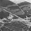
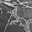
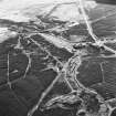
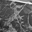
NS95NE 85 9530 5573
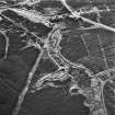
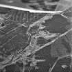
The remains of this mine comprise a conical bing, a hollow to the NNE, probably marking the site of the pit, and a sub-rectangular stance, possibly the site of a building, to the NW of the bing. The bing is depicted on the 2nd edition of the OS 25-inch map (Lanarkshire 1897, sheet xiv.14)
(CSW 1052)
Visited by RCAHMS (SDB) 22 November 1994

