RCAHMS Afforestable Land Survey, Central Scottish Woodland


Date 1992 - 1995
Event ID 550865
Category Project
Type Project
Permalink http://canmore.org.uk/event/550865
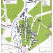
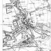
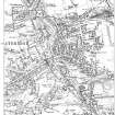
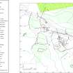
The Central Scotland Forest is a government-sponsored initiative, managed by the Central Scotland Countryside Trust, which aims to improve the environment of the industrial central belt of Scotland, between Glasgow and Edinburgh, primarily by encouraging the establishment of woodlands and forestry. One of the principal targets of this initiative has been the 'cleaning-up' of the industrial dereliction which is widespread within the area. The archaeological implications of widespread planting, landscaping or even wholesale removal of industrial remains, as well as the more general threat posed to other archaeological sites by an enhanced programme of afforestation, prompted RCAHMS to undertake an assessment of the area, with the aim of exploring and high lighting its archaeological potential. This assessment has involved a desktop analysis of existing archaeological records, including the establishment of a database [MS 731/11, DX 001418], coupled with selective fieldwork to assess the extent of archaeological survival. The database was compiled principally by extracting information from Ordnance Survey (OS) maps published up to the early twentieth century; work on it began in 1992, and it was completed in 1995. Fieldwork was conducted in two main seasons in the summers of 1992 and 1994. During the project the area covered by the Central Scotland Forest initiative (originally known as Central Scotland Woodlands) increased in size. It was decided, however, not to expand the project to bring the additional area into the database, although the more general discussions in this report do cover the larger Forest. The original core area, which is covered by the database, is outlined on [RCAHMS 1998] Fig.3.
This report [RCAHMS 1998b; WP 003896] sets out to describe in general terms the area and its archaeology, and to use the database and the results of fieldwork to illustrate aspects of the industrial development of the area in the nineteenth and early twentieth centuries. Some explanation of its layout may be helpful. A discussion of the project methodology is followed by a brief account of the character of the initiative area, including its geology and current land use, and an introduction to its prehistoric and medieval archaeology, drawn largely from information held in the National Monuments Record of Scotland (NMRS). The industrial development of the area up to the First World War is then introduced, drawing on the database and the maps from which it was derived. Aspects of particular industries are illustrated, and the nature and extent of the archaeological evidence recovered during fieldwork is discussed. A final section turns away from industrial archaeology to look at changes in agriculture and rural settlement patterns.
It must be stressed that this report is not intended to exhaust the possibilities of the data gathered during the project, which remains available to the public in the NMRS for further consultation, research and, indeed, improvement.
The main aims during fieldwork were to assess the survival rate of sites in the database and to identify and record sites that do not appear on the early OS maps. There were two main fieldwork seasons. The first was in July and August 1992, when 150km2 of land at the centre of the area was examined [NS87SW/SE, NS86NW/NE/SE/SW]. There was a brief return to complete that area in the summer of 1993, before the second main season which examined the SE corner of the area, centred around the remains of the Wilsontown Ironworks, in July and August 1994 [55km2, parts of NS95NW/NE/SE/SW and NT05NW/SW]. Fieldwork was also conducted in the southern part of the area by the National Archaeological Survey section of the RCAHMS, as part of its programme of reviewing the archaeological depiction on OS maps [77km2, parts of NS85NE/SE, NS95NW/NE].
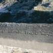
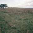
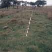
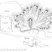
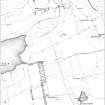
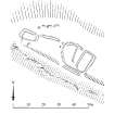
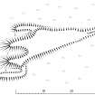
Fieldwork was normally conducted in teams of two. The entries from a particular area were extracted from the database and taken into the field on laptop computers. All known sites (except those situated in dense forestry) were visited and a brief description of the remains, including measurements where appropriate, was added to the database. The ground was also walked to search for unrecorded sites which were added to the database and, where necessary, mapped using Electronic Distance Measurement (EDM) equipment at OS basic scale (1:10,000 or 1:2,500). Occasionally, where sites were particularly well preserved, or displayed features of particular interest, they were recorded in more detail, and maps and plans of these are included in this report. The database entries and any supplementary field-notes were used as the basis for written descriptions of each visited site or group of sites, which have been passed to the NMRS for inclusion in its ORACLE database, while data mapped during field survey has been collected on transparent overlays to the 1:10,000 scale map sheets. Once again, all this information is available for consultation in the NMRS.
RCAHMS 1998, 7-8
See also DES 1991, 80; 1992, 91; 1993, 120; 1994, 103; 1996, 123, 1998, 111 and RCAHMS Annual Reviews 1991-2, 13; 1992-3, 21; 1993-4, 11, 16; 1994-5, 8; 1995-6, 17; 1996-7, 19; 1997-8, 22.
Project Code: CSW
Area: 150km2 + 55km2 + 78km2= 283km2
Database: MS 731/11, DX001418.csv
Linework: TM000316.zip