|
Manuscripts |
MS 731/11 |
Records of the Royal Commission on the Ancient and Historical Monuments of Scotland (RCAHMS), Edinbu |
Printout of RCAHMS Afforestable Land Survey field database (Central Scottish Woodlands) - See DX001418.csv for a digital copy |
1992 |
Item Level |
|
|
Photographs and Off-line Digital Images |
C 41132 |
RCAHMS Aerial Photography |
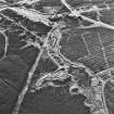
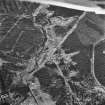
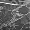
Wilsontown, oblique aerial view, taken from the NE, showing the bings of two coal mines at the bottom, and the remains of ironworks, workers' rows, lime kilns, coke ovens and buildings across the remainder of the photograph, including a large area of bell pits in the centre and top left-hand corner. |
2/2/1995 |
Item Level |
|
|
Photographs and Off-line Digital Images |
C 41133 |
RCAHMS Aerial Photography |
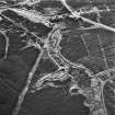
Wilsontown, oblique aerial view, taken from the NE, showing the bings of two coal mines at the bottom, and the remains of ironworks, workers' rows, lime kilns, coke ovens and buildings across the remainder of the photograph. |
2/2/1995 |
Item Level |
|
|
Photographs and Off-line Digital Images |
C 41136 |
RCAHMS Aerial Photography |
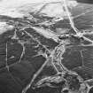
Wilsontown, oblique aerial view, taken from the E, showing the bings of two coal mines in the centre left of the photograph, and the remains of a workers' row, and an area of bell pits, in the centre right. |
2/2/1995 |
Item Level |
|
|
Photographs and Off-line Digital Images |
C 41139 |
RCAHMS Aerial Photography |
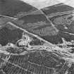
Wilsontown, oblique aerial view, taken from the SSW, showing the bings of two coal mines at the top of the photograph, and the remains of workers' rows, buildings and bell pits in the bottom half. |
2/2/1995 |
Item Level |
|
|
Photographs and Off-line Digital Images |
C 41140 |
RCAHMS Aerial Photography |
Wilsontown, oblique aerial view, taken from the NE, showing the bings of two coal mines in the centre of the photograph, and the remains a worker's row, and bell pits, at the bottom. |
2/2/1995 |
Item Level |
|
|
Photographs and Off-line Digital Images |
B 97368 CS |
RCAHMS Aerial Photography |
Wilsontown, oblique aerial view, taken from the W, showing the spoil heaps of two coal mines in the centre of the photograph, and bell pits at the right-hand edge. |
2/2/1995 |
Item Level |
|
|
Photographs and Off-line Digital Images |
B 97369 CS |
RCAHMS Aerial Photography |
Wilsontown, oblique aerial view, taken from the W, showing the spoil heaps of two coal mines in the centre of the photograph. |
2/2/1995 |
Item Level |
|
|
Photographs and Off-line Digital Images |
B 97371 CS |
RCAHMS Aerial Photography |
Wilsontown, oblique aerial view, taken from the WNW, showing the spoil heaps of two coal mines in the left centre of the photograph, bell pits and a workers' row in the centre, and further workers' rows and buildings to the right centre. |
2/2/1995 |
Item Level |
|
|
Photographs and Off-line Digital Images |
B 97376 CS |
RCAHMS Aerial Photography |
Wilsontown, oblique aerial view, taken from the WSW, showing the remains of a workers' row and bell pits in the centre right of the photograph, and the spoil heaps of two coal mines in the centre left. |
2/2/1995 |
Item Level |
|
|
Photographs and Off-line Digital Images |
B 97377 CS |
RCAHMS Aerial Photography |
Wilsontown, oblique aerial view, taken from the W, showing the remains of workers' rows, the public house and shop in the bottom right-hand corner and the centre of the photograph, bell pits in the top half, and the spoil heaps of two coal mines in the centre left. |
2/2/1995 |
Item Level |
|
|
Photographs and Off-line Digital Images |
B 97380 CS |
RCAHMS Aerial Photography |
Wilsontown, oblique aerial view, taken from the SW, showing the remains of workers' rows, the public house and shop in the bottom half of the photograph, and bell pits in the centre right. |
2/2/1995 |
Item Level |
|
|
Photographs and Off-line Digital Images |
B 97381 CS |
RCAHMS Aerial Photography |
Wilsontown, oblique aerial view, taken from the S, showing the remains of workers' rows along the left edge of the photograph, bell pits in the centre, and a reservoir in the bottom half. |
2/2/1995 |
Item Level |
|
|
Photographs and Off-line Digital Images |
B 97383 CS |
RCAHMS Aerial Photography |
Wilsontown, oblique aerial view, taken from the E, showing the spoil heaps of two coal mines in the centre of the photograph. |
2/2/1995 |
Item Level |
|
 |
On-line Digital Images |
SC 503576 |
RCAHMS Aerial Photography |
Scanned image of oblique aerial view, taken from the NE, showing the bings of two coal mines at the bottom, and the remains of ironworks, workers' rows, lime kilns, coke ovens and buildings across the remainder of the photograph, including a large area of bell pits in the centre and top left-hand corner. |
2/2/1995 |
Item Level |
|
 |
On-line Digital Images |
SC 1683566 |
RCAHMS Aerial Photography |
Wilsontown, oblique aerial view, taken from the NE, showing the bings of two coal mines at the bottom, and the remains of ironworks, workers' rows, lime kilns, coke ovens and buildings across the remainder of the photograph, including a large area of bell pits in the centre and top left-hand corner. |
2/2/1995 |
Item Level |
|
 |
On-line Digital Images |
SC 1728811 |
RCAHMS Aerial Photography |
Wilsontown, oblique aerial view, taken from the NE, showing the bings of two coal mines at the bottom, and the remains of ironworks, workers' rows, lime kilns, coke ovens and buildings across the remainder of the photograph. |
2/2/1995 |
Item Level |
|
 |
On-line Digital Images |
SC 1728814 |
RCAHMS Aerial Photography |
Wilsontown, oblique aerial view, taken from the E, showing the bings of two coal mines in the centre left of the photograph, and the remains of a workers' row, and an area of bell pits, in the centre right. |
2/2/1995 |
Item Level |
|
 |
On-line Digital Images |
SC 1728817 |
RCAHMS Aerial Photography |
Wilsontown, oblique aerial view, taken from the SSW, showing the bings of two coal mines at the top of the photograph, and the remains of workers' rows, buildings and bell pits in the bottom half. |
2/2/1995 |
Item Level |
|
 |
On-line Digital Images |
SC 1728818 |
RCAHMS Aerial Photography |
Wilsontown, oblique aerial view, taken from the NE, showing the bings of two coal mines in the centre of the photograph, and the remains a worker's row, and bell pits, at the bottom. |
2/2/1995 |
Item Level |
|
|
Digital Files (Non-image) |
DX 001418 |
Records of the Royal Commission on the Ancient and Historical Monuments of Scotland (RCAHMS), Edinbu |
RCAHMS Structures Database, Central Scotland Woodland |
1992 |
Item Level |
|
|
Digital Files (Non-image) |
TM 000316 |
Records of the Royal Commission on the Ancient and Historical Monuments of Scotland (RCAHMS), Edinbu |
ZIP file containing dxf data sets used to create illustrations for Forts, Farms and Furnaces, Archaeology in the Central Scotland Forest, RCAHMS 1998 (WP003896.pdf) along with dxf files of survey overlays. |
1992 |
Item Level |
|
|
Digital Files (Non-image) |
TM 002211 |
Records of the Royal Commission on the Ancient and Historical Monuments of Scotland (RCAHMS), Edinbu |
ZIP file containing all survey linework collected as part of the RCAHMS survey of Central Scotland Woodland area. SHP and Geojson file formats with extra attribution added to the linework. |
1992 |
Item Level |
|


